Vicdessos
| Vicdessos | ||
|---|---|---|
|
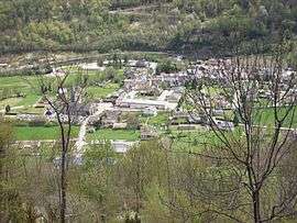
A general view of Vicdessos | ||
| ||
 Vicdessos | ||
|
Location within Occitanie region  Vicdessos | ||
| Coordinates: 42°46′14″N 1°29′57″E / 42.7706°N 1.4992°ECoordinates: 42°46′14″N 1°29′57″E / 42.7706°N 1.4992°E | ||
| Country | France | |
| Region | Occitanie | |
| Department | Ariège | |
| Arrondissement | Foix | |
| Canton | Sabarthès | |
| Intercommunality | Auzat-Vicdessos | |
| Government | ||
| • Mayor (2014–2020) | Jean Magalhaes | |
| Area1 | 6.01 km2 (2.32 sq mi) | |
| Population (2008)2 | 511 | |
| • Density | 85/km2 (220/sq mi) | |
| Time zone | CET (UTC+1) | |
| • Summer (DST) | CEST (UTC+2) | |
| INSEE/Postal code | 09334 / 09220 | |
| Elevation |
652–1,585 m (2,139–5,200 ft) (avg. 705 m or 2,313 ft) | |
|
1 French Land Register data, which excludes lakes, ponds, glaciers > 1 km² (0.386 sq mi or 247 acres) and river estuaries. 2 Population without double counting: residents of multiple communes (e.g., students and military personnel) only counted once. | ||
.svg.png)
Vicdessos is a commune in the Ariège department in southwestern France.
Geography
The superficy of Vicdessos is of about 6,01km2 with a minimum elevation of 652 meters and a maximum elevation of 1585 meters.
Location
This Pyrennean township lies in the Natural regional park of Pyrenées ariégoises in the Vicdessos valley, at the feet of the Montcalm mountains.
Vicdessos is 15 km far from Tarascon-sur-Ariège and 95 km far from Toulouse.
Population
Inhabitants of Vicdessos are called Vicdessosiens.
| Historical population | ||
|---|---|---|
| Year | Pop. | ±% |
| 1962 | 535 | — |
| 1968 | 585 | +9.3% |
| 1975 | 580 | −0.9% |
| 1982 | 602 | +3.8% |
| 1990 | 483 | −19.8% |
| 1999 | 461 | −4.6% |
| 2008 | 511 | +10.8% |
See also
References
| Wikimedia Commons has media related to Vicdessos. |
This article is issued from Wikipedia - version of the 7/21/2016. The text is available under the Creative Commons Attribution/Share Alike but additional terms may apply for the media files.