Siguer
| Siguer | ||
|---|---|---|
|
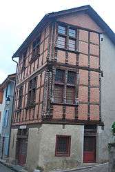
Home of the counts of Foix | ||
| ||
 Siguer | ||
|
Location within Occitanie region  Siguer | ||
| Coordinates: 42°45′55″N 1°33′59″E / 42.7653°N 1.5664°ECoordinates: 42°45′55″N 1°33′59″E / 42.7653°N 1.5664°E | ||
| Country | France | |
| Region | Occitanie | |
| Department | Ariège | |
| Arrondissement | Foix | |
| Canton | Vicdessos | |
| Government | ||
| • Mayor (2008–2014) | Robert Moureau | |
| Area1 | 38.73 km2 (14.95 sq mi) | |
| Population (2008)2 | 86 | |
| • Density | 2.2/km2 (5.8/sq mi) | |
| Time zone | CET (UTC+1) | |
| • Summer (DST) | CEST (UTC+2) | |
| INSEE/Postal code | 09295 / 09220 | |
| Elevation |
615–2,902 m (2,018–9,521 ft) (avg. 745 m or 2,444 ft) | |
|
1 French Land Register data, which excludes lakes, ponds, glaciers > 1 km² (0.386 sq mi or 247 acres) and river estuaries. 2 Population without double counting: residents of multiple communes (e.g., students and military personnel) only counted once. | ||
.svg.png)
Siguer is a commune in the Ariège department in southwestern France.
Population
Inhabitants of Siguer are called Siguerois.
| Historical population | ||
|---|---|---|
| Year | Pop. | ±% |
| 1806 | 885 | — |
| 1851 | 1,027 | +16.0% |
| 1856 | 900 | −12.4% |
| 1901 | 642 | −28.7% |
| 1921 | 384 | −40.2% |
| 1946 | 253 | −34.1% |
| 1962 | 148 | −41.5% |
| 1968 | 89 | −39.9% |
| 1975 | 76 | −14.6% |
| 1982 | 93 | +22.4% |
| 1990 | 65 | −30.1% |
| 1999 | 96 | +47.7% |
| 2008 | 86 | −10.4% |
See also
References
| Wikimedia Commons has media related to Siguer. |
This article is issued from Wikipedia - version of the 12/16/2014. The text is available under the Creative Commons Attribution/Share Alike but additional terms may apply for the media files.