Suc-et-Sentenac
| Suc-et-Sentenac | |
|---|---|
|
A general view of Suc-et-Sentenac | |
 Suc-et-Sentenac | |
|
Location within Occitanie region  Suc-et-Sentenac | |
| Coordinates: 42°47′00″N 1°28′36″E / 42.7833°N 1.4767°ECoordinates: 42°47′00″N 1°28′36″E / 42.7833°N 1.4767°E | |
| Country | France |
| Region | Occitanie |
| Department | Ariège |
| Arrondissement | Foix |
| Canton | Vicdessos |
| Intercommunality | Auzat-Vicdessos |
| Government | |
| • Mayor (2008–2014) | Madeleine Souquet |
| Area1 | 31.69 km2 (12.24 sq mi) |
| Population (2008)2 | 60 |
| • Density | 1.9/km2 (4.9/sq mi) |
| Time zone | CET (UTC+1) |
| • Summer (DST) | CEST (UTC+2) |
| INSEE/Postal code | 09302 / 09220 |
| Elevation |
752–2,196 m (2,467–7,205 ft) (avg. 1,000 m or 3,300 ft) |
|
1 French Land Register data, which excludes lakes, ponds, glaciers > 1 km² (0.386 sq mi or 247 acres) and river estuaries. 2 Population without double counting: residents of multiple communes (e.g., students and military personnel) only counted once. | |
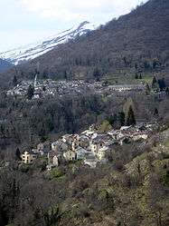
Suc-et-Sentenac is a commune in the Ariège department in southwestern France.
Population
Inhabitants of Suc-et-Sentenac are called Sucatels.
| Historical population | ||
|---|---|---|
| Year | Pop. | ±% |
| 1962 | 51 | — |
| 1968 | 100 | +96.1% |
| 1975 | 89 | −11.0% |
| 1982 | 84 | −5.6% |
| 1990 | 66 | −21.4% |
| 1999 | 103 | +56.1% |
| 2008 | 60 | −41.7% |
See also
References
| Wikimedia Commons has media related to Suc-et-Sentenac. |
This article is issued from Wikipedia - version of the 3/22/2015. The text is available under the Creative Commons Attribution/Share Alike but additional terms may apply for the media files.