Seymour, Indiana
| Seymour, Indiana | |
|---|---|
| City | |
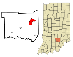 Location in the state of Indiana | |
| Coordinates: 38°57′23″N 85°53′24″W / 38.95639°N 85.89000°WCoordinates: 38°57′23″N 85°53′24″W / 38.95639°N 85.89000°W | |
| Country | United States |
| State | Indiana |
| County | Jackson |
| Townships | Jackson, Redding Hamilton |
| Government | |
| • Mayor | Craig A. Luedeman (R) |
| Area[1] | |
| • Total | 11.43 sq mi (29.60 km2) |
| • Land | 11.42 sq mi (29.58 km2) |
| • Water | 0.01 sq mi (0.03 km2) 0.09% |
| Elevation | 604 ft (184 m) |
| Population (2010)[2] | |
| • Total | 17,503 |
| • Estimate (2012[3]) | 18,520 |
| • Density | 1,532.7/sq mi (591.8/km2) |
| Time zone | EST (UTC-5) |
| • Summer (DST) | EDT (UTC-4) |
| ZIP code | 47274 |
| Area code(s) | 812 & 930 |
| FIPS code | 18-68832[4] |
| GNIS feature ID | 0443233[5] |
| Website | http://www.seymourcity.com/ |
Seymour is a city in Jackson County, Indiana, United States. The population was 17,503 at the 2010 census. Seymour is called the "Crossroads of America" because the north/south and east/west railroads intersect in downtown.
The north/south line, the Jeffersonville, Madison and Indianapolis Railroad, was built in the 1840s connecting Indianapolis to the Ohio River at Jeffersonville. It ran through the Shields farm at the area that is now Seymour.
In 1852 when the east/west railroad, the Ohio and Mississippi Railroad, was going to be built, Capt. Meedy Shields, who was the cousin of General John Tipton persuaded the surveyor, John Seymour, into putting it through his land, in return for which he named the town Seymour. All trains had to stop at a crossroad, making Seymour a bustling community.
Seymour is the birthplace of singer John Mellencamp, former Indiana 9th District U.S. Representative Baron Hill, Texas lawyer Paul Eggers, Miss America 2009 Katie Stam, retired professional wrestler Rip Rogers, and Robert Shields whose personal diary earned him a place in the Guinness Book of World Records. Robert William Shields was a distant cousin of Seymour founder Meedy Shields.
Geography
Seymour is located at 38°57′23″N 85°53′24″W / 38.95639°N 85.89000°W (38.956350, -85.890068).[6]
According to the 2010 census, Seymour has a total area of 11.425 square miles (29.59 km2), of which 11.42 square miles (29.58 km2) (or 99.96%) is land and 0.005 square miles (0.01 km2) (or 0.04%) is water.[1]
Climate
The climate in this area is characterized by hot, humid summers and generally mild to cool winters. According to the Köppen Climate Classification system, Seymour has a humid subtropical climate, abbreviated "Cfa" on climate maps.[7]
Demographics
2010 census
As of the census[2] of 2010, there were 17,503 people, 6,907 households, and 4,514 families residing in the city. The population density was 1,532.7 inhabitants per square mile (591.8/km2). There were 7,719 housing units at an average density of 675.9 per square mile (261.0/km2). The racial makeup of the city was 90.3% White, 1.3% African American, 0.2% Native American, 1.2% Asian, 0.1% Pacific Islander, 5.1% from other races, and 1.8% from two or more races. Hispanic or Latino of any race were 11.5% of the population.
There were 6,907 households of which 34.4% had children under the age of 18 living with them, 45.3% were married couples living together, 13.5% had a female householder with no husband present, 6.5% had a male householder with no wife present, and 34.6% were non-families. 28.1% of all households were made up of individuals and 9.8% had someone living alone who was 65 years of age or older. The average household size was 2.49 and the average family size was 3.01.
The median age in the city was 35.5 years. 25.3% of residents were under the age of 18; 8.7% were between the ages of 18 and 24; 28.6% were from 25 to 44; 24% were from 45 to 64; and 13.4% were 65 years of age or older. The gender makeup of the city was 48.7% male and 51.3% female.
2000 census
As of the census[4] of 2000, there were 18,101 people, 7,231 households, and 4,743 families residing in the city. The population density was 1,670.3 people per square mile (644.7/km²). There were 7,709 housing units at an average density of 711.4 per square mile (274.6/km²). The racial makeup of the city was 93.40% White, 1.02% African American, 0.30% Native American, 1.43% Asian, 0.05% Pacific Islander, 2.93% from other races, and 0.86% from two or more races. Hispanic or Latino of any race were 4.85% of the population.
There were 7,231 households out of which 32.6% had children under the age of 18 living with them, 49.4% were married couples living together, 11.5% had a female householder with no husband present, and 34.4% were non-families. 28.5% of all households were made up of individuals and 11.6% had someone living alone who was 65 years of age or older. The average household size was 2.46 and the average family size was 2.99.
In the city the population was spread out with 25.5% under the age of 18, 10.2% from 18 to 24, 31.4% from 25 to 44, 19.4% from 45 to 64, and 13.5% who were 65 years of age or older. The median age was 34 years. For every 100 females there were 95.7 males. For every 100 females age 18 and over, there were 93.0 males.
The median income for a household in the city was $36,883, and the median income for a family was $43,357. Males had a median income of $30,638 versus $22,265 for females. The per capita income for the city was $18,222. About 8.0% of families and 10.0% of the population were below the poverty line, including 9.7% of those under age 18 and 11.6% of those age 65 or over.
Local media
- WLCL
- WXKU : 92.7 FM
- WZZB : 1390 AM
- WJAA : 96.3 FM
- WJCP : 97.7 FM and 1460 AM
- WJLR : 91.5 FM (K-Love)
- Seymour Times
- The Tribune is a newspaper published Mondays through Saturdays in Seymour
History
| Historical population | |||
|---|---|---|---|
| Census | Pop. | %± | |
| 1860 | 966 | — | |
| 1870 | 2,372 | 145.5% | |
| 1880 | 4,250 | 79.2% | |
| 1890 | 5,337 | 25.6% | |
| 1900 | 6,445 | 20.8% | |
| 1910 | 6,305 | −2.2% | |
| 1920 | 7,348 | 16.5% | |
| 1930 | 7,508 | 2.2% | |
| 1940 | 8,620 | 14.8% | |
| 1950 | 9,629 | 11.7% | |
| 1960 | 11,629 | 20.8% | |
| 1970 | 13,352 | 14.8% | |
| 1980 | 15,050 | 12.7% | |
| 1990 | 15,576 | 3.5% | |
| 2000 | 18,101 | 16.2% | |
| 2010 | 17,503 | −3.3% | |
| Est. 2015 | 19,478 | [8] | 11.3% |
| Source: US Census Bureau | |||
Seymour was laid out and platted in 1852.[9]
Seymour was the site of the World's first train robbery, in which the train was moving. It was committed by the local Reno Gang, on October 6, 1866 just east of town. The gang was put into prison for the robbery, and later lynched at Hangman's Crossing outside town.
The Freeman Field Mutiny occurred in 1945, in which African-American members of the 477th Bombardment Group attempted to integrate an all-white officers' club at Freeman Army Air Corps Base. The mutiny later led to the integration of the United States military.
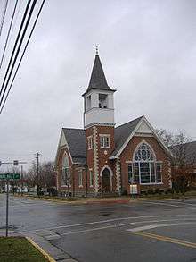
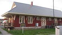
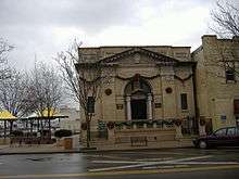
Farmers Club, First Presbyterian Church (Seymour, Indiana), T. Harlan and Helen Montgomery House, Seymour Commercial Historic District, Southern Indiana Railroad Freighthouse, and George H. Vehslage House are listed on the National Register of Historic Places.[10][11][12]
Annual events
- Victory over Japan Day VJ Day Parade ( Celebrates a different group of Veterans every year.)
- Oktoberfest The Lutheran Heritage around Seymour is the main theme of Seymour's Oktoberfest. First weekend in October, with children's rides, flea markets for three days and a parade on Saturday.
- Pepsi Plunge: Annual age group swim meet that typically takes place in July of each year at the city pool in Shield's Park. This competitive event typically gathers near 1,000 competitive swimmers. The home-club for this swim meet is Seymour Swimming, also coached by Dave Boggs. This swim meet is USA Swimming sanctioned.
Notable people
- Katie Stam is Miss Indiana 2008 and Miss America 2009.
- John Mellencamp also known as John Cougar Mellencamp, is an American musician, singer-songwriter, painter, and actor.
- The Elms were an American rock and roll band between 2000 and 2010.
- Reno Gang, committed the first train robbery in America, in Seymour.
- Rip Rogers, retired professional wrestler
- Rob Wiethoff, actor of John Marston in Red Dead Redemption
- Pat Calhoun, former swimmer under Dave Boggs' Seymour High School swim team, went on to compete in the 2000 Summer Olympics in the 100 Breastroke. He qualified for the Olympics as a student-athlete of Auburn University.
Nearby points of interest
- Freeman Municipal Airport is a public use airport, and it is located at 2.6 miles (4.2 km) south-southwest of the downtown. During the World War II, it was the Freeman Army Airfield.
- Brown County, Indiana is located at 25 miles (40 km) northwest of the downtown.
- Muscatatuck National Wildlife Refuge[13] is located at 3 miles (5 km) east of the downtown.
- Southern Indiana Center for the Arts (including gallery of John Mellencamp oil paintings)
References
- 1 2 "G001 - Geographic Identifiers - 2010 Census Summary File 1". United States Census Bureau. Retrieved 2015-07-29.
- 1 2 "American FactFinder". United States Census Bureau. Retrieved 2012-12-11.
- ↑ "Population Estimates". United States Census Bureau. Retrieved 2013-06-25.
- 1 2 "American FactFinder". United States Census Bureau. Retrieved 2008-01-31.
- ↑ "US Board on Geographic Names". United States Geological Survey. 2007-10-25. Retrieved 2008-01-31.
- ↑ "US Gazetteer files: 2010, 2000, and 1990". United States Census Bureau. 2011-02-12. Retrieved 2011-04-23.
- ↑ Climate Summary for Seymour, Indiana
- ↑ "Annual Estimates of the Resident Population for Incorporated Places: April 1, 2010 to July 1, 2015". Retrieved July 2, 2016.
- ↑ History of Jackson County, Indiana: From the Earliest Time to the Present, with Biographical Sketches, Notes, Etc., Together with an Extended History of the Northwest, the Indiana Territory and the State of Indiana. Unigraphic. 1886. p. 459.
- ↑ National Park Service (2010-07-09). "National Register Information System". National Register of Historic Places. National Park Service.
- ↑ "National Register of Historic Places Listings". Weekly List of Actions Taken on Properties: 9/20/10 through 9/24/10. National Park Service. 2010-10-01.
- ↑ "National Register of Historic Places Listings". Weekly List of Actions Taken on Properties: 12/27/10 through 12/30/10. National Park Service. 2011-01-07.
- ↑ http://midwest.fws.gov/Muscatatuck/ Muscatatuck National Wildlife Refuge
External links
- City of Seymour, Indiana website
- Jackson County United Way, Indiana website
- Seymour Community Network
- Jackson County Public Library
- The Tribune (local newspaper)
- The Banner (local newspaper)
- Jackson County Red Cross
- Small Town Monthly (local monthly publication)

Municipalities and communities of Jackson County, Indiana, United States | ||
|---|---|---|
| City | ||
| Towns | ||
| Townships | ||
| CDPs | ||
| Other unincorporated communities |
| |