Shire of Koorda
This article is about a local government area. For the town, see Koorda, Western Australia.
| Shire of Koorda Western Australia | |||||||||||||
|---|---|---|---|---|---|---|---|---|---|---|---|---|---|
 Location in Western Australia | |||||||||||||
| Population | 431 (2013 est)[1] | ||||||||||||
| • Density | 0.15199/km2 (0.3937/sq mi) | ||||||||||||
| Established | 1927 | ||||||||||||
| Area | 2,835.7 km2 (1,094.9 sq mi) | ||||||||||||
| Mayor | Janet Brooks | ||||||||||||
| Council seat | Koorda | ||||||||||||
| Region | Wheatbelt | ||||||||||||
| State electorate(s) | Central Wheatbelt | ||||||||||||
| Federal Division(s) | Durack | ||||||||||||
 | |||||||||||||
| Website | Shire of Koorda | ||||||||||||
| |||||||||||||
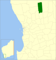
The Shire of Koorda is a local government area in the Wheatbelt region of Western Australia, about 240 kilometres (150 mi) northeast of Perth, the state capital. The Shire covers an area of 2,836 square kilometres (1,095 sq mi) and its seat of government is the town of Koorda.
History
In 1927, the Koorda Road District was gazetted out of land previously administered by the Wyalkatchem and Mount Marshall Road Boards. On 1 July 1961, it became a Shire under the Local Government Act 1960.[2]
Wards
The shire has been divided into 4 wards, each with two councillors.
- Town Ward
- Central Ward
- North Ward
- South Ward
Towns and localities
References
- ↑ "3218.0 Regional Population Growth, Australia. Table 5. Estimated Resident Population, Local Government Areas, Western Australia". 3 April 2014. Retrieved 11 September 2014.
- ↑ WA Electoral Commission, Municipality Boundary Amendments Register (release 3.0), 31 May 2007.
External links
Coordinates: 30°49′52″S 117°29′02″E / 30.831°S 117.484°E
This article is issued from Wikipedia - version of the 11/15/2016. The text is available under the Creative Commons Attribution/Share Alike but additional terms may apply for the media files.