Shire of Pingelly
| Shire of Pingelly Western Australia | |||||||||||||
|---|---|---|---|---|---|---|---|---|---|---|---|---|---|
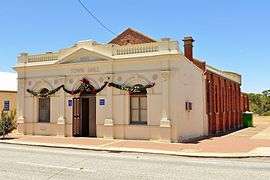 Pingelly Town Hall, 2014 | |||||||||||||
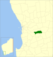 Location in Western Australia | |||||||||||||
| Population | 1,195 (2013 est)[1] | ||||||||||||
| • Density | 0.9231/km2 (2.3907/sq mi) | ||||||||||||
| Established | 1891 | ||||||||||||
| Area | 1,294.6 km2 (499.8 sq mi) | ||||||||||||
| Mayor | Shirley Lange | ||||||||||||
| Council seat | Pingelly | ||||||||||||
| Region | Wheatbelt | ||||||||||||
| State electorate(s) | Wagin | ||||||||||||
| Federal Division(s) | Pearce | ||||||||||||
|
| |||||||||||||
| Website | Shire of Pingelly | ||||||||||||
| |||||||||||||
The Shire of Pingelly is a local government area in the Wheatbelt region of Western Australia, about 160 kilometres (99 mi) southeast of the state capital, Perth, between the Shires of Brookton and Cuballing along the Great Southern Highway. The Shire covers an area of 1,295 square kilometres (500 sq mi), and its seat of government is the town of Pingelly.
History
On 24 December 1891, the Morambine Road District was created. On 21 February 1913, it was renamed Pingelly. On 1 July 1961, it became a Shire following enactment of the Local Government Act 1960.[2]
Wards
From 20 October 2007, Pingelly is no longer divided into wards, and its 8 councillors represent the entire shire.
The ward systems created under successive divisions were as follows:[2]
| 1921 | 1986 | 1992 | 2003 |
|---|---|---|---|
| Pingelly Ward (3) | Pingelly Ward (4) | Town Ward (4) | |
| Central Ward (2) | Mourambine Ward (1) | Hotham Ward (1) | Hotham Ward (2) |
| Noonebin Ward (1) | Jingaring Ward (1) | Jingaring Ward (2) | |
| North East Ward (1) | Kulyaling Ward (1) | Kulyaling Ward (2) | |
| North West Ward (1) | Tutanning Ward (1) | Tutanning Ward (2) | |
| South East Ward (1) | |||
| South West Ward (1) | |||
Towns and localities
- Pingelly
- Boyagin
- Dattening
- Kulyaling
- Moorumbine
Population
| Year | Population |
|---|---|
| 1911 | 1,879 |
| 1921 | 1,644 |
| 1933 | 1,496 |
| 1947 | 1,230 |
| 1954 | 1,519 |
| 1961 | 1,639 |
| 1966 | 1,453 |
| 1971 | 1,447 |
| 1976 | 1,446 |
| 1981 | 1,410 |
| 1986 | 1,371 |
| 1991 | 1,171 |
| 1996 | 1,132 |
| 2001 | 1,122 |
| 2006 | 1,168 |
Notable councillors
- George Sewel, Pingelly Roads Board member 1904–1915, chairman 1914–1915; later a state MP
References
- ↑ "3218.0 Regional Population Growth, Australia. Table 5. Estimated Resident Population, Local Government Areas, Western Australia". 3 April 2014. Retrieved 11 September 2014.
- 1 2 WA Electoral Commission, Municipality Boundary Amendments Register (release 3.0), 31 July 2007.
External links
Coordinates: 32°32′02″S 117°05′10″E / 32.534°S 117.086°E