Town of Bassendean
| Town of Bassendean Western Australia | |||||||||||||
|---|---|---|---|---|---|---|---|---|---|---|---|---|---|
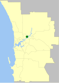 Location of Town of Bassendean within inner Perth metropolitan area | |||||||||||||
| Population | 16,101 (2015 est)[1] | ||||||||||||
| • Density | 1,548/km2 (4,010/sq mi) | ||||||||||||
| Established | 1901 | ||||||||||||
| Area | 10.4 km2 (4.0 sq mi) | ||||||||||||
| Mayor | John Gangell | ||||||||||||
| Council seat | Bassendean | ||||||||||||
| Region | Eastern Metropolitan Perth | ||||||||||||
| State electorate(s) | Bassendean | ||||||||||||
| Federal Division(s) | Perth | ||||||||||||
|
| |||||||||||||
| Website | Town of Bassendean | ||||||||||||
| |||||||||||||
The Town of Bassendean is a local government area in the northeastern suburbs of the Western Australian capital city of Perth, 6 kilometres (4 mi) west of the industrial centre of Midland and about 12 kilometres (7 mi) northeast of Perth's central business district. The Town covers an area of 10.4 square kilometres (4.0 sq mi), maintains 97 km of roads and has an estimated population of 14,404 (2011). The Town of Bassendean is a member of the Eastern Metropolitan Regional Council.
History
The West Guildford Road District was created on 10 May 1901. It was renamed Bassendean on 7 July 1922, and on 1 July 1961, became the Shire of Bassendean following the enactment of the Local Government Act 1960. It became a town on 1 July 1975.[2][3]
Wards
The town is divided into three wards, each of three councillors. The mayor is elected by the councillors.
- North Ward
- East Ward
- West Ward
Suburbs
Mayors
Population
| Year | Population |
|---|---|
| 1911 | 987 |
| 1921 | 2,736 |
| 1933 | 3,803 |
| 1947 | 5,243 |
| 1954 | 7,152 |
| 1961 | 8,310 |
| 1966 | 9,747 |
| 1971 | 11,360 |
| 1976 | 11,382 |
| 1981 | 11,807 |
| 1986 | 12,836 |
| 1991 | 13,109 |
| 1996 | 13,230 |
| 2001 | 13,362 |
| 2006 | 13,462 |
| 2011 | 14,404 |
References
- ↑ "3218.0 – Regional Population Growth, Australia, 2014–15". Australian Bureau of Statistics. Retrieved 29 September 2016.
- ↑ WA Electoral Commission, Municipality Boundary Amendments Register (release 3.0), 31 July 2007.
- ↑ "Local Government Act, 1960-1974. Shire of Bassendean. Change of Status. Order in Council. (per LG. BS-1-10)". Western Australia Government Gazette. 18 April 1975. p. 1975:1152.
External links
Coordinates: 31°54′18″S 115°56′56″E / 31.905°S 115.949°E