Waterloo, Grant County, Wisconsin
- There is also another Town of Waterloo and the City of Waterloo in Jefferson County.
| Waterloo, Wisconsin | |
|---|---|
| Town | |
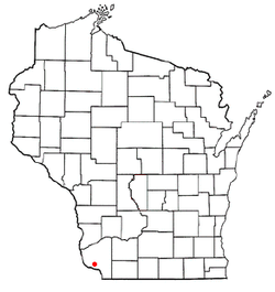 Location of Waterloo, Wisconsin | |
| Coordinates: 42°43′28″N 90°49′50″W / 42.72444°N 90.83056°WCoordinates: 42°43′28″N 90°49′50″W / 42.72444°N 90.83056°W | |
| Country | United States |
| State | Wisconsin |
| County | Grant |
| Area | |
| • Total | 44.6 sq mi (115.5 km2) |
| • Land | 38.2 sq mi (98.9 km2) |
| • Water | 6.4 sq mi (16.6 km2) |
| Elevation[1] | 689 ft (210 m) |
| Population (2000) | |
| • Total | 557 |
| • Density | 14.6/sq mi (5.6/km2) |
| Time zone | Central (CST) (UTC-6) |
| • Summer (DST) | CDT (UTC-5) |
| Area code(s) | 608 |
| FIPS code | 55-83900[2] |
| GNIS feature ID | 1584362[1] |
Waterloo is a town in Grant County in the U.S. state of Wisconsin. The population was 557 at the 2000 census. The unincorporated communities of Burton and McCartney is located in the town.
Geography
According to the United States Census Bureau, the town has a total area of 44.6 square miles (115.5 km²), of which, 38.2 square miles (98.9 km²) of it is land and 6.4 square miles (16.6 km²) of it (14.40%) is water.
Demographics
As of the census[2] of 2000, there were 557 people, 210 households, and 165 families residing in the town. The population density was 14.6 people per square mile (5.6/km²). There were 234 housing units at an average density of 6.1 per square mile (2.4/km²). The racial makeup of the town was 98.92% White, 0.54% Native American, 0.36% from other races, and 0.18% from two or more races. Hispanic or Latino of any race were 0.90% of the population.
There were 210 households out of which 30.5% had children under the age of 18 living with them, 69.0% were married couples living together, 6.2% had a female householder with no husband present, and 21.4% were non-families. 17.6% of all households were made up of individuals and 3.3% had someone living alone who was 65 years of age or older. The average household size was 2.65 and the average family size was 3.01.
In the town the population was spread out with 23.5% under the age of 18, 8.8% from 18 to 24, 26.0% from 25 to 44, 30.7% from 45 to 64, and 11.0% who were 65 years of age or older. The median age was 39 years. For every 100 females there were 115.1 males. For every 100 females age 18 and over, there were 106.8 males.
The median income for a household in the town was $36,932, and the median income for a family was $40,313. Males had a median income of $27,500 versus $19,118 for females. The per capita income for the town was $17,579. About 9.5% of families and 15.3% of the population were below the poverty line, including 22.6% of those under age 18 and 10.9% of those age 65 or over.
Notable people
- Daniel Raymond Burt, businessman and Wisconsin Territorial legislator, lived in the town.[3]
- Edward H. Sprague, Wisconsin State legislator, was born in the town.[4]
References
- 1 2 "US Board on Geographic Names". United States Geological Survey. 2007-10-25. Retrieved 2008-01-31.
- 1 2 "American FactFinder". United States Census Bureau. Retrieved 2008-01-31.
- ↑ 'The Convention of 1846,' Milo Milton Quaife, Wisconsin Historical Society: 1919, Biographical Sketch of Daniel Raymond Bury, pg. 764
- ↑ USGenWeb Archives
Municipalities and communities of Grant County, Wisconsin, United States | ||
|---|---|---|
| Cities | 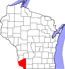 | |
| Villages | ||
| Towns |
| |
| CDPs | ||
| Unincorporated communities |
| |
| Ghost town | ||
| Footnotes | ‡This populated place also has portions in an adjacent county or counties | |