Werley, Wisconsin
| Werley, Wisconsin | |
|---|---|
| Unincorporated community | |
 Werley, Wisconsin  Werley, Wisconsin | |
| Coordinates: 43°01′10″N 90°45′55″W / 43.01944°N 90.76528°WCoordinates: 43°01′10″N 90°45′55″W / 43.01944°N 90.76528°W | |
| Country | United States |
| State | Wisconsin |
| County | Grant |
| Elevation | 771 ft (235 m) |
| Time zone | Central (CST) (UTC-6) |
| • Summer (DST) | CDT (UTC-5) |
| Area code(s) | 608 |
| GNIS feature ID | 1577875[1] |
Werley is an unincorporated community in the town of Mount Ida, Grant County, Wisconsin, United States, at latitude 43.019 and longitude -90.765, where Star Lane feeds into County Road K, roughly five miles west-northwest of Fennimore.[1][2]
There used to be a narrow gauge railway run by the Chicago and Northwestern Railway which ran nearby.[3]
Werley was named after local settler and legislator Gottlieb Wehrle, whose name was pronounced "Werley" by the local residents.[4] The community used to be called Climbing Rock.[5]
References
- 1 2 "Werley, Wisconsin". Geographic Names Information System. United States Geological Survey.
- ↑ Werley populated place profile; hometown locator.com
- ↑ Hazen, Floyd Willard. Floyd Hazen's History of Werley, Wisconsin and the "Dinky Railroad", C & NW RY: An Anthology of the "Werley Nickel Plate" Fennimore, Wisconsin: Steven Hazen, 2003
- ↑ "Term: Werley [origin of place name]" Dictionary of Wisconsin History"
- ↑ Chicago and North Western Railway Company (1908). A History of the Origin of the Place Names Connected with the Chicago & North Western and Chicago, St. Paul, Minneapolis & Omaha Railways. p. 137.
Municipalities and communities of Grant County, Wisconsin, United States | ||
|---|---|---|
| Cities | 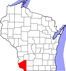 | |
| Villages | ||
| Towns |
| |
| CDPs | ||
| Unincorporated communities |
| |
| Ghost town | ||
| Footnotes | ‡This populated place also has portions in an adjacent county or counties | |
This article is issued from Wikipedia - version of the 10/26/2016. The text is available under the Creative Commons Attribution/Share Alike but additional terms may apply for the media files.