Avilla, Indiana
| Town of Avilla, Indiana | |
|---|---|
| Town | |
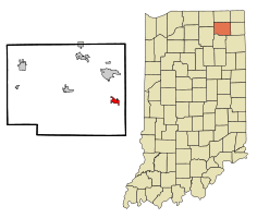 Location in the state of Indiana | |
| Coordinates: 41°21′50″N 85°14′11″W / 41.36389°N 85.23639°WCoordinates: 41°21′50″N 85°14′11″W / 41.36389°N 85.23639°W | |
| Country | United States |
| State | Indiana |
| County | Noble |
| Township | Allen |
| Area[1] | |
| • Total | 1.48 sq mi (3.83 km2) |
| • Land | 1.48 sq mi (3.83 km2) |
| • Water | 0 sq mi (0 km2) |
| Elevation[2] | 965 ft (294 m) |
| Population (2010)[3] | |
| • Total | 2,401 |
| • Estimate (2012)[4] | 2,407 |
| • Density | 1,622.3/sq mi (626.4/km2) |
| Time zone | EST (UTC-5) |
| • Summer (DST) | EST (UTC-5) |
| ZIP code | 46710 |
| Area code | 260 |
| FIPS code[2][5] | 18-02872 |
| GNIS ID[2][5] | 430357 |
Avilla is a town in Allen Township, Noble County, Indiana, United States. The population was 2,401 at the 2010 census.
History
A post office has been in operation at Avilla since 1846.[6] According to Ronald L. Baker, the town may be named after Ávila, Spain.[7]
Geography
Avilla is located at 41°21′50″N 85°14′11″W / 41.36389°N 85.23639°W (41.363977, -85.236524).[8]
According to the 2010 census, Avilla has a total area of 1.48 square miles (3.83 km2), all land.[1]
Demographics
| Historical population | |||
|---|---|---|---|
| Census | Pop. | %± | |
| 1870 | 138 | — | |
| 1880 | 446 | 223.2% | |
| 1890 | 576 | 29.1% | |
| 1900 | 658 | 14.2% | |
| 1910 | 579 | −12.0% | |
| 1920 | 537 | −7.3% | |
| 1930 | 559 | 4.1% | |
| 1940 | 534 | −4.5% | |
| 1950 | 669 | 25.3% | |
| 1960 | 919 | 37.4% | |
| 1970 | 881 | −4.1% | |
| 1980 | 1,272 | 44.4% | |
| 1990 | 1,366 | 7.4% | |
| 2000 | 2,049 | 50.0% | |
| 2010 | 2,401 | 17.2% | |
| Est. 2015 | 2,413 | [9] | 0.5% |
2010 census
As of the 2010 census,[3] there were 2,401 people, 916 households, and 593 families residing in the town. The population density was 1,622.3 inhabitants per square mile (626.4/km2). There were 1,016 housing units at an average density of 686.5 per square mile (265.1/km2). The racial makeup of the town was 98.3% White, 0.7% African American, 0.2% Asian, 0.2% from other races, and 0.6% from two or more races. Hispanic or Latino of any race were 1.5% of the population.
There were 916 households of which 37.0% had children under the age of 18 living with them, 45.5% were married couples living together, 12.1% had a female householder with no husband present, 7.1% had a male householder with no wife present, and 35.3% were non-families. 30.1% of all households were made up of individuals and 11.2% had someone living alone who was 65 years of age or older. The average household size was 2.46 and the average family size was 3.04.
The median age in the town was 36.2 years. 27% of residents were under the age of 18; 8.9% were between the ages of 18 and 24; 26.4% were from 25 to 44; 20.4% were from 45 to 64; and 17.3% were 65 years of age or older. The gender makeup of the town was 46.5% male and 53.5% female.
2000 census
As of the 2000 census,[11] there were 2,049 people, 780 households, and 520 families residing in the town. The population density was 1,499.1 people per square mile (577.5/km²). There were 818 housing units at an average density of 598.5 per square mile (230.5/km²). The racial makeup of the town was 97.32% White, 0.20% Black, 0.15% Native American, 0.44% Asian, 0.24% from other races, and 1.66% from two or more races. Hispanic or Latino of any race were 1.02% of the population.
There were 780 households out of which 35.4% had children under the age of 18 living with them, 53.6% were married couples living together, 8.6% had a female householder with no husband present, and 33.3% were non-families. 28.1% of all households were made up of individuals and 11.0% had someone living alone who was 65 years of age or older. The average household size was 2.45 and the average family size was 2.98.
In the town the population was spread out with 26.4% under the age of 18, 8.6% from 18 to 24, 32.2% from 25 to 44, 15.4% from 45 to 64, and 17.5% who were 65 years of age or older. The median age was 33 years. For every 100 females there were 92.6 males. For every 100 females age 18 and over, there were 88.9 males.
The median income for a household in the town was $42,014, and the median income for a family was $48,800. Males had a median income of $36,773 versus $22,250 for females. The per capita income for the town was $17,591. About 3.0% of families and 5.7% of the population were below the poverty line, including 6.6% of those under the age of 18 and 4.2% of those 65 and older.
Newspapers
The Kendallville Mall mails 14,000 community newspapers to Kendallville homes, and the surrounding area, and hosts a local news and local ads website at and http://www.kendallvillemall.com. Avilla eNooZ, a weekly newspaper, emailed Indiana's first email newspaper in 2009, . The company also produces videos for local businesses and for KendallvilleTV on YouTube.
Businesses
Dollar General, McDonalds/BP gas station, Subway /Marathon, Handy Dandy gas station, Heys Tap, St. James Restaurant, Avilla Pizza and Subs, Avilla Diner & Dairy Treat, Harlan's Country Kitchen, True Value Hardware, Avilla Elementary School.
References
- 1 2 "G001 - Geographic Identifiers - 2010 Census Summary File 1". United States Census Bureau. Retrieved 2015-07-13.
- 1 2 3 "Feature ID 430357". Geographic Names Information System. United States Geological Survey. Retrieved June 30, 2014.
- 1 2 "American FactFinder". United States Census Bureau. Retrieved 2012-12-11.
- ↑ "Incorporated Places and Minor Civil Divisions Datasets: Subcounty Resident Population Estimates: April 1, 2010 to July 1, 2012". United States Census Bureau. Archived from the original on 2013-06-17. Retrieved 2013-06-25.
- 1 2 "FIPS55 Data: Indiana". FIPS55 Data. United States Geological Survey. February 23, 2006. Archived from the original on June 18, 2006. Retrieved June 30, 2014. External link in
|work=(help) - ↑ "Noble County". Jim Forte Postal History. Retrieved 13 September 2015.
- ↑ Baker, Ronald L. (October 1995). From Needmore to Prosperity: Hoosier Place Names in Folklore and History. Indiana University Press. p. 57. ISBN 978-0-253-32866-3.
Possibly the name was borrowed from Avila, the Spanish city.
- ↑ "US Gazetteer files: 2010, 2000, and 1990". United States Census Bureau. 2011-02-12. Retrieved 2011-04-23.
- ↑ "Annual Estimates of the Resident Population for Incorporated Places: April 1, 2010 to July 1, 2015". Retrieved July 2, 2016.
- ↑ "Census of Population and Housing". Census.gov. Archived from the original on May 11, 2015. Retrieved June 4, 2015.
- ↑ "American FactFinder". United States Census Bureau. Archived from the original on 2013-09-11. Retrieved 2008-01-31.
Municipalities and communities of Noble County, Indiana, United States | ||
|---|---|---|
| Cities | ||
| Towns | ||
| Townships | ||
| CDP | ||
| Unincorporated communities |
| |
| Footnotes | ‡This populated place also has portions in an adjacent county or counties | |
| Counties |  | |
|---|---|---|
| Municipalities with population over 10,000 in 2010 | ||
| Municipalities with population 1,000-10,000 in 2010 | ||
| Municipalities with population under 1,000 in 2010 | ||
| CDPs | ||