Grabill, Indiana
| Grabill, Indiana | |
|---|---|
| Town | |
 Location in the state of Indiana | |
| Coordinates: 41°12′36″N 84°58′6″W / 41.21000°N 84.96833°WCoordinates: 41°12′36″N 84°58′6″W / 41.21000°N 84.96833°W | |
| Country | United States |
| State | Indiana |
| County | Allen |
| Township | Cedar Creek |
| Area[1] | |
| • Total | 0.60 sq mi (1.55 km2) |
| • Land | 0.60 sq mi (1.55 km2) |
| • Water | 0 sq mi (0 km2) |
| Elevation | 817 ft (249 m) |
| Population (2010)[2] | |
| • Total | 1,053 |
| • Estimate (2012[3]) | 1,105 |
| • Density | 1,755.0/sq mi (677.6/km2) |
| Time zone | EST (UTC-5) |
| • Summer (DST) | EST (UTC-5) |
| ZIP code | 46741 |
| Area code(s) | 260 |
| FIPS code | 18-28494[4] |
| GNIS feature ID | 0435251[5] |
| Website | www.grabill.net |
Grabill is a town in Cedar Creek Township, Allen County, Indiana, United States. The population was 1,053 at the 2010 census. Today it is known for the presence of antique stores and Amish farms. An incorporated town, Grabill has two community parks within the corporate limits.
History
A post office was established at Grabill in 1902.[6]
Grabill had its start as a town when the Wabash Railroad was extended to that point.[7] Grabill was named for its first postmaster, Joseph A. Grabill.[8]
Geography
Grabill is located at 41°12′36″N 84°58′6″W / 41.21000°N 84.96833°W (41.210049, -84.968358).[9] According to the 2010 census, Grabill has a total area of 0.6 square miles (1.55 km2), all land.[1]
Demographics
| Historical population | |||
|---|---|---|---|
| Census | Pop. | %± | |
| 1930 | 276 | — | |
| 1940 | 288 | 4.3% | |
| 1950 | 370 | 28.5% | |
| 1960 | 495 | 33.8% | |
| 1970 | 570 | 15.2% | |
| 1980 | 658 | 15.4% | |
| 1990 | 751 | 14.1% | |
| 2000 | 1,113 | 48.2% | |
| 2010 | 1,053 | −5.4% | |
| Est. 2015 | 1,127 | [10] | 7.0% |
2010 census
As of the census[2] of 2010, there were 1,053 people, 403 households, and 276 families residing in the town. The population density was 1,755.0 inhabitants per square mile (677.6/km2). There were 443 housing units at an average density of 738.3 per square mile (285.1/km2). The racial makeup of the town was 96.8% White, 0.6% African American, 0.7% Native American, 0.5% Asian, 0.3% from other races, and 1.2% from two or more races. Hispanic or Latino of any race were 1.6% of the population.
There were 403 households of which 37.7% had children under the age of 18 living with them, 52.4% were married couples living together, 13.9% had a female householder with no husband present, 2.2% had a male householder with no wife present, and 31.5% were non-families. 27.5% of all households were made up of individuals and 9.9% had someone living alone who was 65 years of age or older. The average household size was 2.61 and the average family size was 3.22.
The median age in the town was 32.8 years. 30.9% of residents were under the age of 18; 7.2% were between the ages of 18 and 24; 28.9% were from 25 to 44; 21.7% were from 45 to 64; and 11.3% were 65 years of age or older. The gender makeup of the town was 48.1% male and 51.9% female.
2000 census
As of the census[4] of 2000, there were 1,113 people, 420 households, and 307 families residing in the town. The population density was 1,805.1 people per square mile (693.1/km²). There were 442 housing units at an average density of 716.9 per square mile (275.3/km²). The racial makeup of the town was 98.65% White, 0.18% Native American, 0.27% Asian, 0.09% from other races, and 0.81% from two or more races. Hispanic or Latino of any race were 0.99% of the population.
There were 420 households out of which 45.0% had children under the age of 18 living with them, 57.6% were married couples living together, 12.1% had a female householder with no husband present, and 26.9% were non-families. 24.5% of all households were made up of individuals and 8.8% had someone living alone who was 65 years of age or older. The average household size was 2.65 and the average family size was 3.19.
In the town the population was spread out with 32.3% under the age of 18, 7.7% from 18 to 24, 33.8% from 25 to 44, 17.3% from 45 to 64, and 9.0% who were 65 years of age or older. The median age was 31 years. For every 100 females there were 92.6 males. For every 100 females age 18 and over, there were 84.8 males.
The median income for a household in the town was $42,240, and the median income for a family was $48,500. Males had a median income of $36,293 versus $24,688 for females. The per capita income for the town was $17,252. About 5.5% of families and 8.2% of the population were below the poverty line, including 12.4% of those under age 18 and 3.2% of those age 65 or over.
Notable people
- Mark Souder, Former U.S. Representative
References
- 1 2 "G001 - Geographic Identifiers - 2010 Census Summary File 1". United States Census Bureau. Retrieved 2015-07-16.
- 1 2 "American FactFinder". United States Census Bureau. Retrieved 2012-12-11.
- ↑ "Population Estimates". United States Census Bureau. Retrieved 2013-06-25.
- 1 2 "American FactFinder". United States Census Bureau. Retrieved 2008-01-31.
- ↑ "US Board on Geographic Names". United States Geological Survey. 2007-10-25. Retrieved 2008-01-31.
- ↑ "Allen County". Jim Forte Postal History. Retrieved 26 August 2014.
- ↑ Griswold, Bert Joseph; Taylor, Mrs. Samuel R. (1917). The Pictorial History of Fort Wayne, Indiana: A Review of Two Centuries of Occupation of the Region about the Head of the Maumee River. Robert O. Law Company. p. 664.
- ↑ Baker, Ronald L. (October 1995). From Needmore to Prosperity: Hoosier Place Names in Folklore and History. Indiana University Press. p. 148. ISBN 978-0-253-32866-3.
This town was named for Joseph A. Grabill...
- ↑ "US Gazetteer files: 2010, 2000, and 1990". United States Census Bureau. 2011-02-12. Retrieved 2011-04-23.
- ↑ "Annual Estimates of the Resident Population for Incorporated Places: April 1, 2010 to July 1, 2015". Retrieved July 2, 2016.
- ↑ "Census of Population and Housing". Census.gov. Retrieved June 4, 2015.
External links
- Town of Grabill
- Indiana Parley, a weblog for news and politics in northeast Indiana
- Fort Wayne Observed, News, Media and a sense of place
- Maumee Valley Heritage Corridor
Municipalities and communities of Allen County, Indiana, United States | ||
|---|---|---|
| Cities | ||
| Towns | ||
| Townships | ||
| CDPs | ||
| Other unincorporated communities |
| |
| Footnotes | ‡This populated place also has portions in an adjacent county or counties | |
| Counties | 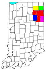 | |
|---|---|---|
| Municipalities with population over 10,000 in 2010 | ||
| Municipalities with population 1,000-10,000 in 2010 | ||
| Municipalities with population under 1,000 in 2010 | ||
| CDPs | ||