Huntertown, Indiana
| Huntertown, Indiana | ||
|---|---|---|
| Town | ||
 | ||
| ||
 Location in the state of Indiana | ||
| Coordinates: 41°13′40″N 85°10′10″W / 41.22778°N 85.16944°WCoordinates: 41°13′40″N 85°10′10″W / 41.22778°N 85.16944°W | ||
| Country | United States | |
| State | Indiana | |
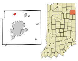
| County | Allen | |
| Area[1] | ||
| • Total | 3.81 sq mi (9.87 km2) | |
| • Land | 3.80 sq mi (9.84 km2) | |
| • Water | 0.01 sq mi (0.03 km2) | |
| Elevation | 837 ft (255 m) | |
| Population (2010)[2] | ||
| • Total | 4,810 | |
| • Estimate (2012[3]) | 5,018 | |
| • Density | 1,265.8/sq mi (488.7/km2) | |
| Time zone | EST (UTC-5) | |
| • Summer (DST) | EST (UTC-5) | |
| ZIP code | 46748 | |
| Area code(s) | 260 | |
| FIPS code | 18-35266[4] | |
| GNIS feature ID | 0436630[5] | |
| Website | www.huntertown.org | |
Huntertown is a town in Allen County, Indiana, United States. The population was 4,810 at the 2010 census, making it one of the fastest-growing areas in northeastern Indiana, with a population increase of 172 percent since 2000.[6][7]
History
Huntertown was originally called "The Opening" because it was a natural forest clearing. Huntertown was first settled circa 1837, founded by William T. Hunter.[8] The village was located along the Lima Plank Road connecting Lima (now Howe) and Fort Wayne. The Perry Centre Seminary was founded in Huntertown in 1856, only to close five years later when the entire faculty and adult students enlisted in the Union Army. The town was platted in 1869, but not incorporated until 1966.[9]
Some of the nation's oldest reliable weather observations are from a nineteenth-century Huntertown farm. Rapin Andrews began keeping meteorological records on July 17, 1839, and continued until his death ten years later. His family continued the observations until April 30, 1874. The diary of weather records was presented to the U.S. Weather Bureau (now the National Weather Service) in 1934. The record highest temperature was 102 °F (39 °C) in July 1846 and the record lowest temperature was −34 °F (−37 °C) on January 29, 1873.[10]
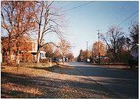
Huntertown today
Since much of Huntertown's growth has come from people moving from urbanized areas like Fort Wayne to new suburban subdivisions, the expectations for services have increased. For example, the town council expanded from three to five members to lessen the workload. The council now is working on creating a new water plant, a parks board, and a new 27-acre (110,000 m2) park. Huntertown is the adopted home of noted artist and historian James B. O'Connor.
The town's weekly newspaper, Northwest News, began operations in the summer of 1997 in the former Huntertown State Bank, site of a 1930s robbery by the John Dillinger gang.[11]
Geography
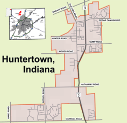
Huntertown is located at 41°13′40″N 85°10′10″W / 41.22778°N 85.16944°W (41.227798, -85.169371)[12] at an elevation of 837 feet (255 m) and sits along State Road 3/Lima Road just north of Fort Wayne. Carroll Road is the southern boundary line between Huntertown and Fort Wayne.
According to the 2010 census, Huntertown has a total area of 3.81 square miles (9.87 km2), of which 3.8 square miles (9.84 km2) (or 99.74%) is land and 0.01 square miles (0.03 km2) (or 0.26%) is water.[1]
Demographics
| Historical population | |||
|---|---|---|---|
| Census | Pop. | %± | |
| 1970 | 775 | — | |
| 1980 | 1,265 | 63.2% | |
| 1990 | 1,330 | 5.1% | |
| 2000 | 1,771 | 33.2% | |
| 2010 | 4,810 | 171.6% | |
| Est. 2015 | 5,387 | [13] | 12.0% |
As of 2000 the median income for a household in the town in 2000 was $52,250, and the median income for a family was $59,219. Males had a median income of $41,150 versus $28,152 for females. The per capita income for the town was $21,232. About 3.0% of families and 4.2% of the population were below the poverty line, including 6.1% of those under age 18 and 6.3% of those age 65 or over.
2010 census
As of the census[2] of 2010, there were 4,810 people, 1,726 households, and 1,299 families residing in the town. The population density was 1,265.8 inhabitants per square mile (488.7/km2). There were 1,823 housing units at an average density of 479.7 per square mile (185.2/km2). The racial makeup of the town was 93.6% White, 1.4% African American, 0.4% Native American, 2.0% Asian, 0.8% from other races, and 1.9% from two or more races. Hispanic or Latino of any race were 2.3% of the population.
There were 1,726 households of which 45.8% had children under the age of 18 living with them, 58.8% were married couples living together, 12.1% had a female householder with no husband present, 4.4% had a male householder with no wife present, and 24.7% were non-families. 19.4% of all households were made up of individuals and 4.7% had someone living alone who was 65 years of age or older. The average household size was 2.79 and the average family size was 3.21.
The median age in the town was 31.5 years. 31.9% of residents were under the age of 18; 7% were between the ages of 18 and 24; 33.4% were from 25 to 44; 21.3% were from 45 to 64; and 6.4% were 65 years of age or older. The gender makeup of the town was 49.2% male and 50.8% female.
Footnotes
- 1 2 "G001 - Geographic Identifiers - 2010 Census Summary File 1". United States Census Bureau. Retrieved 2015-07-17.
- 1 2 "American FactFinder". United States Census Bureau. Retrieved 2012-12-11.
- ↑ "Population Estimates". United States Census Bureau. Archived from the original on June 17, 2013. Retrieved 2013-06-25.
- ↑ "American FactFinder". United States Census Bureau. Archived from the original on September 11, 2013. Retrieved 2008-01-31.
- ↑ "US Board on Geographic Names". United States Geological Survey. 2007-10-25. Retrieved 2008-01-31.
- ↑ US Census Factfinder for Huntertown, Indiana
- ↑ Dan Stockman (2011-02-11). "As suburbs grow, other areas don't". Fort Wayne Journal Gazette. Retrieved 2011-02-11.
- ↑ Griswold, Bert Joseph; Taylor, Mrs. Samuel R. (1917). The Pictorial History of Fort Wayne, Indiana: A Review of Two Centuries of Occupation of the Region about the Head of the Maumee River. Robert O. Law Company. p. 656.
- ↑ Allen County - Fort Wayne Historical Society
- ↑ National Weather Service archives
- ↑ Northwest News
- ↑ "US Gazetteer files: 2010, 2000, and 1990". United States Census Bureau. 2011-02-12. Retrieved 2011-04-23.
- ↑ "Annual Estimates of the Resident Population for Incorporated Places: April 1, 2010 to July 1, 2015". Retrieved July 2, 2016.
- ↑ "Census of Population and Housing". Census.gov. Archived from the original on May 11, 2015. Retrieved June 4, 2015.
External links
- Town of Huntertown, Indiana website
- Huntertown, Indiana Online Neighborhood website
- Huntertown, Indiana News & Forum archive
- Official Huntertown, Albion, and Churubusco News
Municipalities and communities of Allen County, Indiana, United States | ||
|---|---|---|
| Cities | ||
| Towns | ||
| Townships | ||
| CDPs | ||
| Other unincorporated communities |
| |
| Footnotes | ‡This populated place also has portions in an adjacent county or counties | |
| Counties |  | |
|---|---|---|
| Municipalities with population over 10,000 in 2010 | ||
| Municipalities with population 1,000-10,000 in 2010 | ||
| Municipalities with population under 1,000 in 2010 | ||
| CDPs | ||