Saint Joe, Indiana
| Saint Joe, Indiana | |
|---|---|
| Nickname(s): Pickle Town | |
 Location in the state of Indiana | |
| Coordinates: 41°18′53″N 84°54′3″W / 41.31472°N 84.90083°WCoordinates: 41°18′53″N 84°54′3″W / 41.31472°N 84.90083°W | |
| Country | United States |
| State | Indiana |
| County | DeKalb |
| Township | Concord |
| Area[1] | |
| • Total | 0.27 sq mi (0.70 km2) |
| • Land | 0.27 sq mi (0.70 km2) |
| • Water | 0 sq mi (0 km2) |
| Population (2010)[2] | |
| • Total | 460 |
| • Estimate (2012[3]) | 463 |
| • Density | 1,703.7/sq mi (657.8/km2) |
| Time zone | EST (UTC-5) |
| • Summer (DST) | EDT (UTC-4) |
| 1Saint Joe referenced as Town of Saint Joe | |
Saint Joe is a town in Concord Township, DeKalb County, Indiana, United States. The population was 460 at the 2010 census.
History
Saint Joe was laid out in 1875, and incorporated as a town in 1899.[4] The town derives its name from the St. Joseph River.[5]
Geography
Saint Joe is located at 41°18′53″N 84°54′3″W / 41.31472°N 84.90083°W (41.314829, -84.900696).[6]
According to the 2010 census, St. Joe has a total area of 0.27 square miles (0.70 km2), all land.[1]
Demographics
| Historical population | |||
|---|---|---|---|
| Census | Pop. | %± | |
| 1880 | 180 | — | |
| 1900 | 483 | — | |
| 1910 | 391 | −19.0% | |
| 1920 | 386 | −1.3% | |
| 1930 | 407 | 5.4% | |
| 1940 | 437 | 7.4% | |
| 1950 | 479 | 9.6% | |
| 1960 | 499 | 4.2% | |
| 1970 | 564 | 13.0% | |
| 1980 | 546 | −3.2% | |
| 1990 | 452 | −17.2% | |
| 2000 | 478 | 5.8% | |
| 2010 | 460 | −3.8% | |
| Est. 2015 | 463 | [7] | 0.7% |
2010 census
As of the census[2] of 2010, there were 460 people, 157 households, and 115 families residing in the town. The population density was 1,703.7 inhabitants per square mile (657.8/km2). There were 179 housing units at an average density of 663.0 per square mile (256.0/km2). The racial makeup of the town was 95.9% White, 0.9% Asian, 0.4% from other races, and 2.8% from two or more races. Hispanic or Latino of any race were 3.7% of the population.
There were 157 households of which 42.7% had children under the age of 18 living with them, 55.4% were married couples living together, 7.0% had a female householder with no husband present, 10.8% had a male householder with no wife present, and 26.8% were non-families. 19.1% of all households were made up of individuals and 7% had someone living alone who was 65 years of age or older. The average household size was 2.93 and the average family size was 3.39.
The median age in the town was 33.1 years. 32.6% of residents were under the age of 18; 9.9% were between the ages of 18 and 24; 23.7% were from 25 to 44; 23% were from 45 to 64; and 10.9% were 65 years of age or older. The gender makeup of the town was 50.9% male and 49.1% female.
2000 census
As of the census[9] of 2000, there were 478 people, 165 households, and 132 families residing in the town. The population density was 1,687.7 people per square mile (659.1/km²). There were 184 housing units at an average density of 649.6 per square mile (253.7/km²). The racial makeup of the town was 97.49% White, 0.21% African American, 0.21% Native American, 1.46% from other races, and 0.63% from two or more races. Hispanic or Latino of any race were 3.77% of the population.
There were 165 households out of which 45.5% had children under the age of 18 living with them, 64.2% were married couples living together, 10.3% had a female householder with no husband present, and 19.4% were non-families. 18.2% of all households were made up of individuals and 7.3% had someone living alone who was 65 years of age or older. The average household size was 2.90 and the average family size was 3.22.
In the town the population was spread out with 32.2% under the age of 18, 9.8% from 18 to 24, 32.4% from 25 to 44, 15.5% from 45 to 64, and 10.0% who were 65 years of age or older. The median age was 32 years. For every 100 females there were 105.2 males. For every 100 females age 18 and over, there were 102.5 males.
The median income for a household in the town was $36,417, and the median income for a family was $36,833. Males had a median income of $33,125 versus $22,109 for females. The per capita income for the town was $14,570. About 4.6% of families and 5.5% of the population were below the poverty line, including 1.9% of those under age 18 and 12.5% of those age 65 or over.
Emergency services
For EMERGENCIES call 911.
Non-Emergency Central Dispatch for Dekalb County
- Fire & Rescue: Concord Township Fire Department
- Police: Dekalb County Sheriff's Department & Indiana State Police
- EMS: Dekalb EMS
Dekalb County Department of Homeland Security for any non-specific threats.
All Emergency Services are available 24 hours a day.
Education
The town of Saint Joe lies in the school district of Dekalb County Eastern Community School District. Local schools residents attend are:
- Riverdale Elementary School (K-6) in St. Joe
- Butler Elementary (K-6)
- Eastside Junior-Senior High School (7-12)
Parks & Recreation
There are several recreational centers in Saint Joe, including:
- Wild Cherry Park
- Saint Mark's Lutheran Church's Park
- Saint Joseph River Greenway
- Riverdale Elementary School's Playground
- Saint Joe Church of Christ's Playground
- Saint Joe Valley Conservation Club
- Public access to the Saint Joseph River
- Four baseball diamonds:
- Three at Riverdale Elementary
- One at NUCOR
Churches
The town of Saint Joe is home to three churches:
- Saint Joe Church of Christ
- Saint Mark's Lutheran Church
- Coburn Corners Church of Christ
Arts and culture
The town of Saint Joe holds an annual Pickle Festival in honor of the Pickle industry local to the town.
References
- 1 2 "G001 - Geographic Identifiers - 2010 Census Summary File 1". United States Census Bureau. Retrieved 2015-07-25.
- 1 2 "American FactFinder". United States Census Bureau. Retrieved 2012-12-11.
- ↑ "Population Estimates". United States Census Bureau. Retrieved 2013-06-25.
- ↑ History of Dekalb County, Indiana. B.F. Bowen & Co. 1914. p. 153.
- ↑ Baker, Ronald L. (October 1995). From Needmore to Prosperity: Hoosier Place Names in Folklore and History. Indiana University Press. p. 289. ISBN 978-0-253-32866-3.
...which was named for the nearby Saint Joseph River...
- ↑ "US Gazetteer files: 2010, 2000, and 1990". United States Census Bureau. 2011-02-12. Retrieved 2011-04-23.
- ↑ "Annual Estimates of the Resident Population for Incorporated Places: April 1, 2010 to July 1, 2015". Retrieved July 2, 2016.
- ↑ "Census of Population and Housing". Census.gov. Retrieved June 4, 2015.
- ↑ "American FactFinder". United States Census Bureau. Retrieved 2008-01-31.
External links
- Town Website
- Sechler's Pickles
- NUCOR
- Coburn Corners
- Saint Joseph River Greenway on Indiana Trails
- Saint Joseph River Greenway (Official)
- Dekalb County Eastern Community School District website
Municipalities and communities of DeKalb County, Indiana, United States | ||
|---|---|---|
| Cities | ||
| Towns | ||
| Townships | ||
| Unincorporated communities | ||
| Footnotes | ‡This populated place also has portions in an adjacent county or counties | |
| Counties | 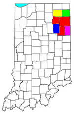 | |
|---|---|---|
| Municipalities with population over 10,000 in 2010 | ||
| Municipalities with population 1,000-10,000 in 2010 | ||
| Municipalities with population under 1,000 in 2010 | ||
| CDPs | ||