Leo-Cedarville, Indiana
| Leo-Cedarville, Indiana | |
|---|---|
| Town | |
| Motto: "A Sense Of Community" | |
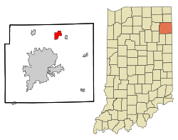 Location of Leo-Cedarville in the state of Indiana | |
| Coordinates: 41°12′54″N 85°0′56″W / 41.21500°N 85.01556°WCoordinates: 41°12′54″N 85°0′56″W / 41.21500°N 85.01556°W | |
| Country | United States |
| State | Indiana |
| County | Allen |
| Township | Cedar Creek |
| Area[1] | |
| • Total | 3.85 sq mi (9.97 km2) |
| • Land | 3.71 sq mi (9.61 km2) |
| • Water | 0.14 sq mi (0.36 km2) |
| Elevation | 797 ft (243 m) |
| Population (2010)[2] | |
| • Total | 3,603 |
| • Estimate (2012[3]) | 3,756 |
| • Density | 971.2/sq mi (375.0/km2) |
| Time zone | Eastern (EST) (UTC-5) |
| • Summer (DST) | EDT (UTC-4) |
| FIPS code | 18-42861[4] |
| GNIS feature ID | 1681810[5] |
| Website | http://www.leocedarville.com/ |
Leo-Cedarville is a town in Cedar Creek Township, Allen County, Indiana, United States. The population was 3,603 at the 2010 census.
History
Once separate villages, Cedarville was platted in 1838, and Leo was founded in 1849.[6]
Leo-Cedarville was formed by the incorporation of the villages of Leo and Cedarville in 1996. This was done so that the two towns could not be annexed by the nearby city of Fort Wayne.
The Hursh Road Bridge was added to the National Register of Historic Places in 1981 and delisted in 1993.[7]
Geography
Leo-Cedarville is located at 41°12′54″N 85°0′56″W / 41.21500°N 85.01556°W (41.214899, -85.015475)[8] along the St. Joseph River and the Cedarville Reservoir.
According to the 2010 census, Leo-Cedarville has a total area of 3.85 square miles (9.97 km2), of which 3.71 square miles (9.61 km2) (or 96.36%) is land and 0.14 square miles (0.36 km2) (or 3.64%) is water.[1]
Education
The town is served by Cedarville Elementary School, Leo Elementary School, and Leo Junior/Senior High School.
Demographics
| Historical population | |||
|---|---|---|---|
| Census | Pop. | %± | |
| 2000 | 2,782 | — | |
| 2010 | 3,603 | 29.5% | |
| Est. 2015 | 3,842 | [9] | 6.6% |
2010 census
As of the census[2] of 2010, there were 3,603 people, 1,187 households, and 1,007 families residing in the town. The population density was 971.2 inhabitants per square mile (375.0/km2). There were 1,234 housing units at an average density of 332.6 per square mile (128.4/km2). The racial makeup of the town was 97.1% White, 0.1% African American, 0.2% Native American, 0.8% Asian, 0.6% from other races, and 1.2% from two or more races. Hispanic or Latino of any race were 1.6% of the population.
There were 1,187 households of which 48.4% had children under the age of 18 living with them, 73.3% were married couples living together, 7.1% had a female householder with no husband present, 4.5% had a male householder with no wife present, and 15.2% were non-families. 13.1% of all households were made up of individuals and 5.7% had someone living alone who was 65 years of age or older. The average household size was 3.04 and the average family size was 3.32.
The median age in the town was 38.1 years. 32.3% of residents were under the age of 18; 7.1% were between the ages of 18 and 24; 24% were from 25 to 44; 27.2% were from 45 to 64; and 9.4% were 65 years of age or older. The gender makeup of the town was 49.8% male and 50.2% female.
2000 census
As of the census[4] of 2000, there were 2,782 people, 922 households, and 778 families residing in the town. The population density was 745.1 people per square mile (288.0/km²). There were 939 housing units at an average density of 251.5 per square mile (97.2/km²). The racial makeup of the town was 97.81% White, 0.07% African American, 0.29% Native American, 0.40% Asian, 0.29% from other races, and 1.15% from two or more races. Hispanic or Latino of any race were 1.04% of the population.

There were 922 households out of which 47.3% had children under the age of 18 living with them, 76.2% were married couples living together, 5.7% had a female householder with no husband present, and 15.6% were non-families. 13.0% of all households were made up of individuals and 5.5% had someone living alone who was 65 years of age or older. The average household size was 3.02 and the average family size was 3.33.
In the town the population was spread out with 32.9% under the age of 18, 6.2% from 18 to 24, 32.6% from 25 to 44, 19.9% from 45 to 64, and 8.4% who were 65 years of age or older. The median age was 34 years. For every 100 females there were 98.0 males. For every 100 females age 18 and over, there were 98.5 males.
The median income for a household in the town was $66,652, and the median income for a family was $70,750. Males had a median income of $48,438 versus $25,552 for females. The per capita income for the town was $22,170. About 1.0% of families and 1.2% of the population were below the poverty line, including none of those under age 18 and 8.6% of those age 65 or over.
References
- 1 2 "G001 - Geographic Identifiers - 2010 Census Summary File 1". United States Census Bureau. Retrieved 2015-07-17.
- 1 2 "American FactFinder". United States Census Bureau. Retrieved 2012-12-11.
- ↑ "Population Estimates". United States Census Bureau. Retrieved 2013-06-25.
- 1 2 "American FactFinder". United States Census Bureau. Retrieved 2008-01-31.
- ↑ "US Board on Geographic Names". United States Geological Survey. 2007-10-25. Retrieved 2008-01-31.
- ↑ Griswold, Bert Joseph; Taylor, Mrs. Samuel R. (1917). The Pictorial History of Fort Wayne, Indiana: A Review of Two Centuries of Occupation of the Region about the Head of the Maumee River. Robert O. Law Company. pp. 662–663.
- ↑ National Park Service (2010-07-09). "National Register Information System". National Register of Historic Places. National Park Service.
- ↑ "US Gazetteer files: 2010, 2000, and 1990". United States Census Bureau. 2011-02-12. Retrieved 2011-04-23.
- ↑ "Annual Estimates of the Resident Population for Incorporated Places: April 1, 2010 to July 1, 2015". Retrieved July 2, 2016.
- ↑ "Census of Population and Housing". Census.gov. Retrieved June 4, 2015.
External links
Municipalities and communities of Allen County, Indiana, United States | ||
|---|---|---|
| Cities | ||
| Towns | ||
| Townships | ||
| CDPs | ||
| Other unincorporated communities |
| |
| Footnotes | ‡This populated place also has portions in an adjacent county or counties | |
| Counties |  | |
|---|---|---|
| Municipalities with population over 10,000 in 2010 | ||
| Municipalities with population 1,000-10,000 in 2010 | ||
| Municipalities with population under 1,000 in 2010 | ||
| CDPs | ||