Pouancé
| Pouancé | ||
|---|---|---|
|
| ||
| ||
 Pouancé | ||
|
Location within Pays de la Loire region  Pouancé | ||
| Coordinates: 47°44′29″N 1°10′30″W / 47.7414°N 1.175°WCoordinates: 47°44′29″N 1°10′30″W / 47.7414°N 1.175°W | ||
| Country | France | |
| Region | Pays de la Loire | |
| Department | Maine-et-Loire | |
| Arrondissement | Segré | |
| Canton | Pouancé | |
| Intercommunality | Communauté de Commune de la région Pouancé-Combrée | |
| Government | ||
| • Mayor (2008–2014) | Pierrick Esnault | |
| Area1 | 48.97 km2 (18.91 sq mi) | |
| Population (2006 estimate)2 | 3,192 | |
| • Density | 65/km2 (170/sq mi) | |
| Time zone | CET (GMT +1) (UTC+1) | |
| • Summer (DST) | CEST (UTC+2) | |
| INSEE/Postal code | 49248 / 49420 | |
| Elevation |
48–108 m (157–354 ft) (avg. 20 m or 66 ft) | |
|
1 French Land Register data, which excludes lakes, ponds, glaciers > 1 km² (0.386 sq mi or 247 acres) and river estuaries. 2 Population without double counting: residents of multiple communes (e.g., students and military personnel) only counted once. | ||
Pouancé is a commune in the Maine-et-Loire department in western France. It is located on the border of 4 French departements: the Maine-et-Loire where its belong, the Mayenne in the North, the Ille-et-Vilaine in the North-west, and the Loire-Atlantique in the West.
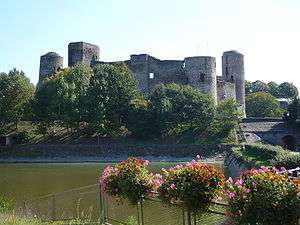
During the Middle-ages, Pouancé is at the border between Anjou, part of the Kingdom of France, and the independent duchy of Brittany. The city gained the nickname of "Door of Anjou, March of Brittany". Until now, the city keeps its partially preserved city walls, some of its city gates and its medieval castle, the second largest in Anjou.
History
The menhir of Pierrefrite is one of the only remains from the prehistory in Pouancé region, along with some stone axes and an arrowhead. The menhir is located on the border of the commune of Armaillé et Saint-Michel-et-Chanveaux. The menhir is made of red slate and is 5 meters tall.
After the discover of pieces of tegulae in a wood, it is supposed that a Roman kiln did exist, and along with it, a Gallo-Roman habitat.
The earlier place of settlement on the territory is supposed to be the village of Saint-Aubin, about one kilometre far from the center of Pouancé. In the walls of Saint-Aubin church (12th century) was found the remains of a Merovingian sarcophagus.
The first known lord of Pouancé was Manguinoë, from 990 to 1037. It is supposed that he built the first castle, in a motte-and-bailey style. For defensive reasons, the motte was built one kilometre from Saint-Aubin, on a slate hill. At the end of the 12th century, a medieval village grew up around, the first towers were built, and the village was fortified. The fortress complete, it counted 15 towers and 3 defensive walls.
During the reign of Charles V of France, a permanent tax, the gabelle, was established on the salt. The Anjou became a Pays de grandes gabelles, where tax was heaviest. Because Brittany was exempted of this tax, an important smuggle developed in the border of Anjou and Brittany. In 1343, a greniers à sel (salt granary) was established in Pouancé to store the salt and judge dispute on the tax. The smuggling was so important in Pouancé that a special jail for the faux-sauniers (name for the salt smugglers) was built.
During the Hundred Years' War, Pouancé has been besieged twice: the first time in 1432 by John VI, Duke of Brittany, allied with English and Scottish troops. The second time in 1443, by John Beaufort, 1st Duke of Somerset. But the city managed to resist every time, and the besiegers were forced to retreat.
During the 16th century, Pouancé was also famous in Anjou for its forges. The French royal navy command commission the forge for several thousand of round shots.
After the French revolution, Pouancé became the chef-lieu of a canton. The canton of Pouancé groups together 14 communes.
Toponymy
The etymology of Pouancé could come from the latin name, Potentius, derived from the latin potens (powerful).[1] Others make its derived from the Celtic pouleum (a hill, or a butte). First mention of Pouancé dated from 1050, when the town is named Poenciacum and Pautiacum. As time goes by, Pouancé born the following name:[2]
|
|
Coat of arms
| Coat of arms of Pouancé | |
| Arms/Standard | Description |
|---|---|
.svg.png) |
Quarterly, first and fourth argent a pale vert, second and third vert a bend argent. |
-2.png) |
Quarterly, first and fourth or a pale vert, second and third vert a bend or. |
Geography
Geology and hydrology
The river Semnon forms part of the commune's northern border along with the Araize.
The river Verzée flows southeastward through the southern part of the commune and crosses the town. It forms the lake of Saint-Aubin, then the lake of Pouancé just under the castle, and finally the lake of Tressé.
Climate
| Month | Jan | Feb | March | Apr | May | June | July | Aug | Sept | Oct | Nov | Dec | Year |
|---|---|---|---|---|---|---|---|---|---|---|---|---|---|
| Average high (°C) | 7,9 | 9,2 | 12,6 | 15,3 | 19 | 22,6 | 24,9 | 24,7 | 21,8 | 17 | 11,4 | 8,4 | 16,2 |
| Average low (°C) | 2,1 | 2,2 | 3,9 | 5,6 | 8,9 | 11,8 | 13,6 | 13,4 | 11,3 | 8,4 | 4,6 | 2,8 | 7,4 |
| Average temperatures (°C) | 5 | 5,7 | 8,2 | 10.4 | 13,9 | 16,2 | 19,2 | 19,1 | 16,5 | 12,7 | 8 | 5,6 | 11,8 |
| Months average of precipitations (mm) | 62,1 | 50,8 | 51,7 | 44,6 | 54,4 | 41,2 | 43,8 | 44,9 | 52,2 | 59,6 | 64,5 | 63,4 | 633,4 |
| Monthly length of sunlight (hours/month) | 70 | 92 | 141 | 179 | 201 | 234 | 248 | 237 | 191 | 129 | 89 | 65 | 1877 |
| Source : Climatologie de 1947 à 2008 - Angers, France | |||||||||||||
Nearby places
 |
Villepot | Saint-Erblon and Senonnes | Renazé | |
| Soudan and Châteaubriant | |
Chazé-Henry | ||
| ||||
| | ||||
| Carbay | La Prévière | Armaillé |
Demography
Evolution
| 1793 | 1800 | 1806 | 1821 | 1831 | 1836 | 1841 | 1846 | 1851 |
|---|---|---|---|---|---|---|---|---|
| 1,034 | 1,306 | 1,915 | 1,956 | 2,560 | 2,765 | 2,821 | 2,758 | 2,895 |
| 1856 | 1861 | 1866 | 1872 | 1876 | 1881 | 1886 | 1891 | 1896 |
| 3,001 | 3,227 | 3,266 | 3,273 | 3,390 | 3,346 | 3,502 | 3,508 | 3,355 |
| 1901 | 1906 | 1911 | 1921 | 1926 | 1931 | 1936 | 1946 | 1954 |
| 3,278 | 3,198 | 3,093 | 2,755 | 2,762 | 2,804 | 2,836 | 3,218 | 3,119 |
| 1962 | 1968 | 1975 | 1982 | 1990 | 1999 | 2006 | - | - |
| 3,094 | 3,017 | 3,165 | 3,299 | 3,279 | 3,307 | 3,192 | - | - |
| Starting in 1962: Population with duplicates - Sources : Cassini[3] et INSEE[4] | ||||||||
Twin cities
-
 Şopotu Nou since 2007 (Website).
See also
References
- ↑ À travers l'histoire de Pouancé, Alain Racineux, Yves Floch Mayenne, 1983, page 22
- ↑ Histoire de Pouancé et des environs, Henri Godivier, seconde édition 2006, Le Livre d'Histoire, page 19
- ↑ "Des villages Cassini ... - Dossier "INDEX"". ehess.fr.
- ↑ "Insee - Conditions de vie-Société - Population et logements par commune depuis le recensement de 1962 (1961 pour les Dom) à 1999 - Population et logements par commune depuis le recensement de 1962 (1961 pour les Dom) à 1999". insee.fr.
| Wikimedia Commons has media related to Pouancé. |