Cognat-Lyonne
| Cognat-Lyonne | ||
|---|---|---|
|
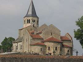
Sainte-Radegonde Church | ||
| ||
 Cognat-Lyonne | ||
|
Location within Auvergne-Rhône-Alpes region  Cognat-Lyonne | ||
| Coordinates: 46°06′33″N 3°18′39″E / 46.1092°N 3.3108°ECoordinates: 46°06′33″N 3°18′39″E / 46.1092°N 3.3108°E | ||
| Country | France | |
| Region | Auvergne-Rhône-Alpes | |
| Department | Allier | |
| Arrondissement | Vichy | |
| Canton | Bellerive-sur-Allier | |
| Intercommunality | Vichy Val d'Allier | |
| Government | ||
| • Mayor (2014–2020) | Raymond Mazal | |
| Area1 | 12.51 km2 (4.83 sq mi) | |
| Population (2012)2 | 689 | |
| • Density | 55/km2 (140/sq mi) | |
| Time zone | CET (UTC+1) | |
| • Summer (DST) | CEST (UTC+2) | |
| INSEE/Postal code | 03080 / 03110 | |
| Elevation |
308–368 m (1,010–1,207 ft) (avg. 360 m or 1,180 ft) | |
|
1 French Land Register data, which excludes lakes, ponds, glaciers > 1 km² (0.386 sq mi or 247 acres) and river estuaries. 2 Population without double counting: residents of multiple communes (e.g., students and military personnel) only counted once. | ||
.svg.png)
Cognat-Lyonne is a commune in the department of Allier in Auvergne in central France.
Population
| Historical population | ||
|---|---|---|
| Year | Pop. | ±% |
| 1962 | 456 | — |
| 1968 | 488 | +7.0% |
| 1975 | 501 | +2.7% |
| 1982 | 474 | −5.4% |
| 1990 | 556 | +17.3% |
| 1999 | 547 | −1.6% |
| 2008 | 636 | +16.3% |
| 2012 | 689 | +8.3% |
Source: INSEE[1]
Government
List of successive mayors:
- 1919-1945: Étienne Pélisson
- 1945-1971: Lucien Riet
- 1971-1977: Pierre Gillet
- 1977-1983: André Goutheraud
- 1983-1989: Raymond Mazal
- 1989-unknown: André Goutheraud
- 2001-current: Raymond Mazal[2]
Culture & Heritage
- Sainte-Radegonde church (12th century): Historical Monument
- Lyonne castle (18th century) built by Robert de Lyonne
- Rilhat castle
See also
References
- ↑ "2012 legal populations - Cognat-Lyonne". INSEE (in French). Retrieved 22 June 2015.
- ↑ "Liste nominative des communes de l'Allier (avec maire, arrondissement et canton)" [Nominative list of communes of Allier (with mayor, arrondissement and canton)] (PDF). Association of Mayors and Presidents of Communities of Allier (in French). 1 April 2015. Archived from the original (PDF) on 18 May 2015. Retrieved 22 June 2015.
| Wikimedia Commons has media related to Cognat-Lyonne. |
This article is issued from Wikipedia - version of the 11/27/2016. The text is available under the Creative Commons Attribution/Share Alike but additional terms may apply for the media files.