Avermes
| Avermes | ||
|---|---|---|
|
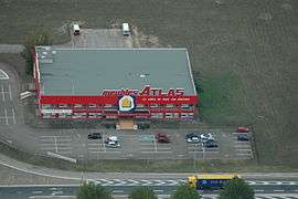
The Atlas factory | ||
| ||
 Avermes | ||
|
Location within Auvergne-Rhône-Alpes region  Avermes | ||
| Coordinates: 46°35′19″N 3°18′29″E / 46.5886°N 3.3081°ECoordinates: 46°35′19″N 3°18′29″E / 46.5886°N 3.3081°E | ||
| Country | France | |
| Region | Auvergne-Rhône-Alpes | |
| Department | Allier | |
| Arrondissement | Moulins | |
| Canton | Moulins-1 | |
| Intercommunality | Moulins | |
| Government | ||
| • Mayor (2014–2020) | Alain Denizot | |
| Area1 | 15.6 km2 (6.0 sq mi) | |
| Population (2013)2 | 3,838 | |
| • Density | 250/km2 (640/sq mi) | |
| Time zone | CET (UTC+1) | |
| • Summer (DST) | CEST (UTC+2) | |
| INSEE/Postal code | 03013 / 03000 | |
| Elevation |
199–262 m (653–860 ft) (avg. 220 m or 720 ft) | |
|
1 French Land Register data, which excludes lakes, ponds, glaciers > 1 km² (0.386 sq mi or 247 acres) and river estuaries. 2 Population without double counting: residents of multiple communes (e.g., students and military personnel) only counted once. | ||
Avermes is a French commune in the Allier department in the Auvergne-Rhône-Alpes region of central France.
The inhabitants of the commune are known as Avermois or Avermoises.[1]
The commune has been awarded two flowers by the National Council of Towns and Villages in Bloom in the Competition of cities and villages in Bloom.[2]
Geography
Avermes is located in the north-east of Allier department in Sologne Bourbonnaise natural region immediately north-west of Moulins. Access to the commune is by Route nationale N7 which comes from Villeneuve-sur-Allier in the north passing through the heart of the commune, with an exit just north of the town, and continues south-east, bypassing Moulins, to Bessay-sur-Allier in the south. The D707 goes from the exit on the N7 in the commune south through the town urban area continuing to Moulins. The centre of the town is accessed by the D283 which loops through the centre from the D707. The D979A forms the eastern border of the commune as it goes from Moulins north-east to Saint-Ennemond. The D29 branches from the D979A just south of the commune and passes through the east of the commune north to join the D133 east of Aurouër. The D29D links the D979A to the D29 in the east of the commune. Apart from the town there are the districtys and hamlets of Chavennes, Les Groiteiers, Ravard, Les Gravettes, Les Plantes, Les Petites-Roches, and L'Etang Chateau. The urban area in the commune spreads along the D707 and along the east bank of the river. The east of the commune is farmland.[3]
The Allier river flows along the western border of the commune and through part of the west of the commune as it flows north to join the Loire just east of Cuffy. An unnamed stream rises in the east of the commune and flows south-west to join the Allier. There are also numerous ponds in the commune.
Neighbouring communes and villages
 |
Montilly | Trévol | Gennetines | |
| Marigny | |
Chézy | ||
| ||||
| | ||||
| Neuvy | Moulins |
History
Avermes was mentioned for the first time in the 8th century.
Heraldry
.svg.png) |
Blazon: Argent three fesses Sable, a bend the same charged with 3 fesses Argent, surcharged at 1 with a rose Gules seeded and barbed the same, at 2 a mullet Gules of 6 points pierced, at 3 a Celtic Crosslet the same. |
Administration
List of Successive Mayors[4]
| From | To | Name | Party | Position |
|---|---|---|---|---|
| 1792 | 1793 | Jean Michel | ||
| 1793 | 1795 | Antoine du Broc | ||
| 1795 | 1804 | Joseph Perreuil | ||
| 1804 | 1807 | Pierre Merle | ||
| 1807 | 1815 | Louis du Broc | ||
| 1815 | 1815 | Jean-Baptiste Laurent | ||
| 1815 | 1817 | Louis du Broc | ||
| 1817 | 1830 | Antoine Durocher | ||
| 1830 | 1830 | Petitville | ||
| 1830 | 1848 | Jean-Baptiste Degrange | ||
| 1848 | 1856 | Adolphe Perreul | ||
| 1856 | 1883 | Toussaint Bouchard | ||
| 1883 | 1912 | Pierre Delvaux | ||
| 1912 | 1919 | Gueullet | ||
| 1919 | 1935 | Claude Morand |
- Mayors from 1935
| From | To | Name | Party | Position |
|---|---|---|---|---|
| 1935 | 1944 | Antoine Page | ||
| 1944 | 1947 | Aumeunier | ||
| 1948 | 1974 | François Reveret | ||
| 1974 | 1977 | Jacques de Fremont | ||
| 1977 | 1985 | Claude Wormser | ||
| 1985 | 2002 | René Charrette | ||
| 2002 | 2020 | Alain Denizot[5] |
(Not all data is known)
Demography
In 2013 the commune had 3,838 inhabitants.[6] The evolution of the number of inhabitants is known from the population censuses conducted in the commune since 1793. From the 21st century, a census of communes with fewer than 10,000 inhabitants is held every five years, unlike larger communes that have a sample survey every year.[Note 1]
| 1793 | 1800 | 1806 | 1821 | 1831 | 1836 | 1841 | 1846 | 1851 |
|---|---|---|---|---|---|---|---|---|
| 400 | 510 | 381 | 450 | 505 | 556 | 574 | 696 | 719 |
| 1856 | 1861 | 1866 | 1872 | 1876 | 1881 | 1886 | 1891 | 1896 |
|---|---|---|---|---|---|---|---|---|
| 737 | 756 | 816 | 824 | 844 | 843 | 930 | 906 | 911 |
| 1901 | 1906 | 1911 | 1921 | 1926 | 1931 | 1936 | 1946 | 1954 |
|---|---|---|---|---|---|---|---|---|
| 925 | 932 | 914 | 890 | 951 | 1,033 | 1,075 | 1,186 | 1,333 |
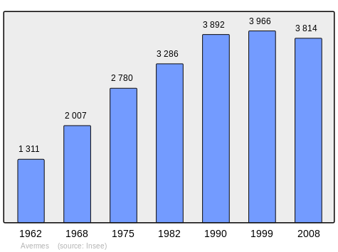
| 1962 | 1968 | 1975 | 1982 | 1990 | 1999 | 2006 | 2010 | 2013 |
|---|---|---|---|---|---|---|---|---|
| 1,311 | 2,007 | 2,780 | 3,286 | 3,892 | 3,966 | 3,852 | 3,808 | 3,838 |
Sources : Ldh/EHESS/Cassini until 1962, INSEE database from 1968 (population without double counting and municipal population from 2006)
Economy

This is the main suburb of Moulins for both leisure and industrial activities with a fairground (Moulins Foirexpo), a cultural multi-purpose hall (Islea), and two metallurgical factories: JPM ex-Chauvat employing about 400 people, and Potain Cranes which employs about 250 people. These are the two largest employers in the commune with ITM (an Intermarché logistics depot with 200 employees), the Leclerc Centre (distribution with 200 employees), Desamais (hardware with 110 employees), and Chapier (DIY store - 50 employees).
Culture and heritage
Civil heritage
The commune has one building that is registered as an historical monument:
- The Chateau of Segange (15th century)
 [7]
[7]
- Other sites of interest
The Home of Champfeu, dating from the 17th and 18th centuries with the large buildings of the old seminary and the large chapel built in his enclosure in 1925 (Route de Paris).
Religious heritage
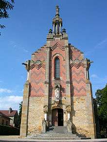
The commune has one religious building that is registered as an historical monument:
- The Church of Saint Michel or Notre-Dame de la Salette (1871).[8] The church is built in bi-coloured bricks, grey and light grey (Volvic stone).
See also
Notes
- ↑ At the beginning of the 21st century, the methods of identification have been modified by Law No. 2002-276 of 27 February 2002, the so-called "law of local democracy" and in particular Title V "census operations" allows, after a transitional period running from 2004 to 2008, the annual publication of the legal population of the different French administrative districts. For communes with a population greater than 10,000 inhabitants, a sample survey is conducted annually, the entire territory of these communes is taken into account at the end of the period of five years. The first "legal population" after 1999 under this new law came into force on 1 January 2009 and was based on the census of 2006.
References
- ↑ "Avermes (03000)". habitants.fr (in French). SARL Patagos. Retrieved 24 January 2016.
- ↑ Avermes in the Competition for Towns and Villages in Bloom Archived December 10, 2014, at the Wayback Machine. (French)
- ↑ Google Maps
- ↑ List of Mayors of France (French)
- ↑ Re-elected in 2014: "Liste nominative des communes de l'Allier (avec maire, arrondissement et canton)" [Nominative list of communes of Allier (with mayor, arrondissement and canton)] (PDF). Association of Mayors and Presidents of Communities of Allier. 1 April 2015. Archived from the original (PDF) on 18 May 2015. Retrieved 13 May 2015.
- ↑ "Legal populations - Avermes". INSEE (in French). Retrieved 24 January 2016.
- ↑ Ministry of Culture, Mérimée PA00092980 Chateau of Segange (French)
- ↑ Ministry of Culture, Mérimée PA03000018 Church of Saint Michel (French)
External links
| Wikimedia Commons has media related to Avermes. |
- The Community of the agglomération of Moulins official website (French)
- Avermes on Lion1906
- Averme on the 1750 Cassini Map
- Avermes on the INSEE website (French)
- INSEE (French)