Meillers
| Meillers | |
|---|---|
|
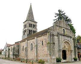
The church in Meillers | |
 Meillers | |
|
Location within Auvergne-Rhône-Alpes region  Meillers | |
| Coordinates: 46°30′28″N 3°05′37″E / 46.5078°N 3.0936°ECoordinates: 46°30′28″N 3°05′37″E / 46.5078°N 3.0936°E | |
| Country | France |
| Region | Auvergne-Rhône-Alpes |
| Department | Allier |
| Arrondissement | Moulins |
| Canton | Souvigny |
| Intercommunality | Bocage Sud |
| Government | |
| • Mayor (2014–2020) | Jean-Marie Pagliai[1] |
| Area1 | 23.48 km2 (9.07 sq mi) |
| Population (2012)2 | 150 |
| • Density | 6.4/km2 (17/sq mi) |
| Time zone | CET (UTC+1) |
| • Summer (DST) | CEST (UTC+2) |
| INSEE/Postal code | 03170 / 03210 |
| Elevation |
240–426 m (787–1,398 ft) (avg. 330 m or 1,080 ft) |
|
1 French Land Register data, which excludes lakes, ponds, glaciers > 1 km² (0.386 sq mi or 247 acres) and river estuaries. 2 Population without double counting: residents of multiple communes (e.g., students and military personnel) only counted once. | |
Meillers is a commune in the Allier department in central France.
Population
| Historical population | ||
|---|---|---|
| Year | Pop. | ±% |
| 1962 | 267 | — |
| 1968 | 309 | +15.7% |
| 1975 | 240 | −22.3% |
| 1982 | 225 | −6.2% |
| 1990 | 173 | −23.1% |
| 1999 | 169 | −2.3% |
| 2008 | 157 | −7.1% |
| 2012 | 150 | −4.5% |
| Source: INSEE (1968–2012) | ||
See also
References
- ↑ "Liste nominative des communes de l'Allier" [Nominative list of communes of Allier] (PDF). Association of Mayors and Presidents of Communities of Allier (in French). 1 April 2015. Retrieved 23 October 2015.
| Wikimedia Commons has media related to Meillers. |
This article is issued from Wikipedia - version of the 7/21/2016. The text is available under the Creative Commons Attribution/Share Alike but additional terms may apply for the media files.