Bézenet
| Bézenet | |
|---|---|
 Bézenet | |
|
Location within Auvergne-Rhône-Alpes region  Bézenet | |
| Coordinates: 46°19′48″N 2°50′45″E / 46.33°N 2.8458°ECoordinates: 46°19′48″N 2°50′45″E / 46.33°N 2.8458°E | |
| Country | France |
| Region | Auvergne-Rhône-Alpes |
| Department | Allier |
| Arrondissement | Montluçon |
| Canton | Commentry |
| Intercommunality | Région de Montmarault |
| Government | |
| • Mayor (2014–2020) | Daniel Piquandet |
| Area1 | 9.94 km2 (3.84 sq mi) |
| Population (2013)2 | 1,006 |
| • Density | 100/km2 (260/sq mi) |
| Time zone | CET (UTC+1) |
| • Summer (DST) | CEST (UTC+2) |
| INSEE/Postal code | 03027 / 03170 |
| Elevation |
270–376 m (886–1,234 ft) (avg. 342 m or 1,122 ft) |
|
1 French Land Register data, which excludes lakes, ponds, glaciers > 1 km² (0.386 sq mi or 247 acres) and river estuaries. 2 Population without double counting: residents of multiple communes (e.g., students and military personnel) only counted once. | |
Bézenet (Occitan, Besenet) is a commune in the Allier department in central France.
Geography
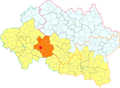 Bézenet in the canton of Montmarault (before March 2015).
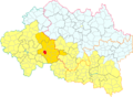 Bézenet in the Région de Montmarault intercommunality.
Population
| Historical population | ||
|---|---|---|
| Year | Pop. | ±% |
| 1962 | 896 | — |
| 1968 | 973 | +8.6% |
| 1975 | 1,009 | +3.7% |
| 1982 | 1,005 | −0.4% |
| 1990 | 922 | −8.3% |
| 1999 | 953 | +3.4% |
| 2008 | 962 | +0.9% |
| 2013 | 1,006 | +4.6% |
| Source: INSEE (1968–2013[1]) | ||
See also
References
- ↑ "2013 legal populations - Bézenet". INSEE (in French). Retrieved 1 February 2016.
| Wikimedia Commons has media related to Bézenet. |
This article is issued from Wikipedia - version of the 2/1/2016. The text is available under the Creative Commons Attribution/Share Alike but additional terms may apply for the media files.