East Haddam, Connecticut
| East Haddam, Connecticut | ||
|---|---|---|
| Town | ||
| ||
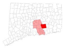 Location within Middlesex County, Connecticut | ||
| Coordinates: 41°29′N 72°24′W / 41.483°N 72.400°WCoordinates: 41°29′N 72°24′W / 41.483°N 72.400°W | ||
| Country | United States | |
| State | Connecticut | |
| NECTA | Hartford | |
| Region | Midstate Region | |
| Incorporated | 1734 | |
| Government | ||
| • Type | Selectman–town meeting | |
| • First selectman | Mark Walter (R) | |
| Area | ||
| • Total | 56.6 sq mi (146.6 km2) | |
| • Land | 54.3 sq mi (140.7 km2) | |
| • Water | 2.2 sq mi (5.8 km2) | |
| Elevation | 486 ft (148 m) | |
| Population (2010)[1] | ||
| • Total | 9,126 | |
| • Density | 162/sq mi (63/km2) | |
| Time zone | Eastern (UTC-5) | |
| • Summer (DST) | Eastern (UTC-4) | |
| ZIP code | 06423, 06469 | |
| Area code(s) | 860 | |
| FIPS code | 09-22280 | |
| GNIS feature ID | 0213422 | |
| Website |
www | |
East Haddam is a town in Middlesex County, Connecticut, United States. The population was 9,126 at the 2010 census.
History
Until 1650, the area of East Haddam was inhabited by at least three tribes of Indians: the Wangunks, the Mohegans and the Nehantics. The Indians called the area “Machimoodus,” the place of noises, because of numerous earthquakes that were recorded between 1638 and 1899. Loud rumblings, the “Moodus Noises,” could be heard for miles surrounding the epicenter of the quakes near Mt. Tom. The land, which is now Haddam and East Haddam, was purchased by settlers from the Indians in 1662 for thirty coats – worth about $100.
Layout of the highways began in 1669 with Creek Row about ¼ mile east of the River and Town Street “The Great Highway” about ¼ mile east of Creek Row. The first permanent settlers established homesteads along Creek Row in 1685. By 1700, there were thirty families living in East Haddam. Agricultural and timber farming, shipbuilding, tanneries and blacksmiths were among the early commerce. Captain John Chapman began ferry service across the Connecticut River in 1695, which ended with the completion of the swing bridge in 1913.
East Haddam was incorporated as a separate town from Haddam in 1734. By 1756, there were nearly 2,000 residents, with the Millington District as the most populated. Growth of commerce brought a surge in population to around 3,000 people by the mid-1800s. In the nineteenth century, Moodus was the “Twine Capital of America,” with twelve mills in operation.[2] Visitors and residents such as actor, William Gillette, whose castle home was completed in 1914, were drawn to the area known for its rural charm and natural scenery. The growth of the resort areas of Lake Hayward, Bashan Lake and Moodus Reservoir began in the early 1900s and was a booming business for the next fifty years.[3]
Geography
According to the United States Census Bureau, the town has a total area of 56.6 square miles (147 km2), of which, 54.3 square miles (141 km2) of it is land and 2.2 square miles (5.7 km2) of it (3.96%) is water.
Principal communities
- Bashan
- East Haddam Center
- Hadlyme
- Leesville
- Little Haddam
- Millington
- Moodus
- North Plain
Demographics
| Historical population | |||
|---|---|---|---|
| Census | Pop. | %± | |
| 1820 | 2,572 | — | |
| 1850 | 2,610 | — | |
| 1860 | 3,056 | 17.1% | |
| 1870 | 2,951 | −3.4% | |
| 1880 | 3,032 | 2.7% | |
| 1890 | 2,599 | −14.3% | |
| 1900 | 2,485 | −4.4% | |
| 1910 | 2,422 | −2.5% | |
| 1920 | 2,312 | −4.5% | |
| 1930 | 2,114 | −8.6% | |
| 1940 | 2,217 | 4.9% | |
| 1950 | 2,554 | 15.2% | |
| 1960 | 3,637 | 42.4% | |
| 1970 | 4,676 | 28.6% | |
| 1980 | 5,621 | 20.2% | |
| 1990 | 6,676 | 18.8% | |
| 2000 | 8,333 | 24.8% | |
| 2010 | 9,126 | 9.5% | |
| Est. 2014 | 9,127 | [4] | 0.0% |

As of the census[6] of 2000, there were 8,333 people, 3,174 households, and 2,285 families residing in the town. The population density was 153.4 people per square mile (59.2/km2). There were 4,015 housing units at an average density of 73.9 per square mile (28.5/km2). The racial makeup of the town was 97.26% White, 0.84% African American, 0.28% Native American, 0.40% Asian, 0.46% from other races, and 0.77% from two or more races. Hispanic or Latino of any race were 0.98% of the population.
There were 3,174 households out of which 35.2% had children under the age of 18 living with them, 62.3% were married couples living together, 6.9% had a female householder with no husband present, and 28.0% were non-families. 21.4% of all households were made up of individuals and 8.1% had someone living alone who was 65 years of age or older. The average household size was 2.58 and the average family size was 3.02.
In the town the population was spread out with 25.5% under the age of 18, 4.8% from 18 to 24, 33.3% from 25 to 44, 25.8% from 45 to 64, and 10.6% who were 65 years of age or older. The median age was 38 years. For every 100 females there were 100.1 males. For every 100 females age 18 and over, there were 96.2 males.
The median income for a household in the town was $62,304, and the median income for a family was $70,091. Males had a median income of $45,500 versus $36,055 for females. The per capita income for the town was $28,112. About 1.0% of families and 2.9% of the population were below the poverty line, including 1.5% of those under age 18 and 1.5% of those age 65 or over.
| Voter Registration and Party Enrollment as of October 25, 2005[7] | |||||
|---|---|---|---|---|---|
| Party | Active Voters | Inactive Voters | Total Voters | Percentage | |
| Democratic | 1,529 | 91 | 1,620 | 28.72% | |
| Republican | 1,181 | 56 | 1,237 | 21.93% | |
| Unaffiliated | 2,598 | 179 | 2,777 | 49.24% | |
| Minor parties | 5 | 1 | 6 | 0.11% | |
| Total | 5,313 | 327 | 5,640 | 100% | |
Education
Public
The East Haddam Public School System has about 1,100 students in grades PreK–12; about 121 certified "teachers", 70 support staff and 7 administrators. Mr. Brian Reas is superintendent of schools.[8] Located in Moodus, Connecticut, the three schools in the public school system are:
- Nathan Hale-Ray High School (grades 9–12) - about 418 students[9]
- Nathan Hale-Ray Middle School (Grades 4–8) - about 573 students[10]
- East Haddam Elementary School (Grades Pre–K3) - about 430 students[11]
Private
- Franklin Academy – "A Boarding and Day School for Students with Nonverbal Learning Differences in grades 8-12", according to the school's Web site. The private, nonprofit school was opened in 2003 and has a campus of 75 acres (300,000 m2).
Attractions

Cultural
- East Haddam Libraries - 2 public libraries, The East Haddam Free Public Library (18 Plains Rd, Moodus) and The Rathbun Free Memorial Library (36 Main St, East Haddam). EHFPL is well known for its teen and family programs, while Rathbun Library is known for its adult and child programs. Both have special collections in addition to offering basic library fare: Books for readers of all ages, DVD/Videos, Public Computer access, etc.
- Gillette Castle State Park - historic former home of late actor William Gillette and river outlook on Route 82.
- Goodspeed Opera House - award-winning theater, on Route 82 near the East Haddam Bridge.
- I-park Artists-in-Residence Program sponsored by the I-Park Foundation, Inc. (not open to the general public, except by invitation or for special events)[12]
Historical
- Amasa Day House - historic museum, on Plains Road.
- Boardman House - built in 1860 as the home of Luther Boardman, now a luxury inn.[13]
- East Haddam Bridge - built in 1913, the 899-foot long swing bridge is reputed to be the longest of its type in the world.[14]
- East Haddam Historical Society Museum – local history exhibits, including pictures of the construction of the East Haddam Swing Bridge.[15]
- First Church of Christ - Congregational Church built in 1794, on Town Street.
- Gelston House - built in 1736, once a tavern and boarding house, now a restaurant and bar adjacent from the Goodspeed Opera House.
- Gideon Higgins house - site on the Underground Railroad, on Route 149.[16]
- Johnsonville Village - once a thriving mill community, then a Victorian Era tourist attraction, now an abandoned ghost town.
- Nathan Hale School House - historic site, on Route 149, one of two Nathan Hale School Houses in Connecticut.
- St. Stephen's Bell - thought to be the oldest bell in the New World, it was cast in a Spanish monastery in 815AD and brought to the US in 1834. It now hangs at St. Stephen's Episcopal Church on Route 149.
- Venture Smith's Grave - a site on the Connecticut Freedom Trail.
Natural
- Devil's Hopyard State Park
- Eagle viewing sites:
- Along the Connecticut River at the Town Office parking lot
- Near Riverhouse, overlooking the north side of the East Haddam Bridge
- Lake Hayward, 1.5-mile (2.4 km) long, 0.5-mile (800 m) wide spring-fed lake in northern section of East Haddam. Originally called Long Pond.
- Machimoodus State Park
- Sunrise Resort State Park
Notable people
- Morgan Bulkeley (1837-1922), Baseball Hall of Fame inductee, first president of the National League, was born in East Haddam.
- George Comer (1858–1937), polar explorer and whaler who called East Haddam his home for most of his life; the Comer Strait of northern Southampton Island and the almost flightless Gallinula comeri were named in his honor.
- Christopher Dodd, a former United States Senator for Connecticut, lives in East Haddam.
- John Gardner Griffin, Wisconsin State Assemblyman, was born in East Haddam.
- Bill Griffith (*1944), cartoonist.
- Louis P. Harvey (1820-1862), seventh Governor of Wisconsin, born in East Haddam.
- Uriel Holmes (1764–1827), United States Representative from Connecticut was born in East Haddam.
- George White Pratt, Wisconsin State Senator, was born in East Haddam.
- Joseph Spencer, lawyer, soldier, and statesman during the Revolutionary War, was born and died in East Haddam.
In popular culture
East Haddam has been used as a filming location for many different films and TV shows including:
- Billy Joel's 1993 music video for River of Dreams was filmed in several locations around East Haddam, including the chapel in Johnsonville Village.
- In season 1, episode 2 of Gilmore Girls, b-roll was used of East Haddam, showing the Gelston House and the Goodspeed Opera House, standing in for the fictional town of Stars Hollow.
- The Cuba Gooding Jr film Something Whispered was filmed partially on location in Johnsonville Village.
References
- ↑ U.S. Census Bureau Population Estimates
- ↑
- ↑
- ↑ "Annual Estimates of the Resident Population for Incorporated Places: April 1, 2010 to July 1, 2014". Retrieved June 4, 2015.
- ↑ "Census of Population and Housing". Census.gov. Retrieved June 4, 2015.
- ↑ "American FactFinder". United States Census Bureau. Retrieved 2008-01-31.
- ↑ "Registration and Party Enrollment Statistics as of October 25, 2005" (PDF). Connecticut Secretary of State. Archived from the original (PDF) on 2006-09-23. Retrieved 2006-10-02.
- ↑ East Haddam Public Schools
- ↑ Nathan Hale-Ray High School
- ↑ Nathan Hale-Ray Middle School
- ↑ East Haddam Elementary School
- ↑ "The I-Park Mission". I-Park.org/.
- ↑ Boardman House Inn
- ↑
- ↑ Connecticut, Massachusetts & Rhode Island Tourbook 2007 Edition. (2007) p 42. AAA Publishing, Heathrow, Florida
- ↑
External links
| Wikivoyage has a travel guide for East Haddam. |

- Town government Web site
- East Haddam Public Schools
- East Haddam pictures from Simon Pure Productions Web site
- Essay on the early history of East Haddam from Simon Pure Productions Web site
- Central Regional Tourism District
- Goodspeed Opera House
- Rathbun Memorial Library
- East Haddam Free Public Library
- East Haddam Land Trust
- Official Gillette Castle State Park Web site
- another Web page about Gillette Castle State Park
- Eightmile River Study Committee Web site
Municipalities and communities of Middlesex County, Connecticut, United States | ||
|---|---|---|
| City | 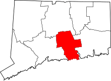 | |
| Towns | ||
| Borough | ||
| Other communities | ||