Preston, Connecticut
| Preston, Connecticut | ||
|---|---|---|
| Town | ||
| ||
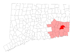 Location in New London County, Connecticut | ||
| Coordinates: 41°31′N 72°0′W / 41.517°N 72.000°WCoordinates: 41°31′N 72°0′W / 41.517°N 72.000°W | ||
| Country | United States | |
| State | Connecticut | |
| NECTA | Norwich-New London | |
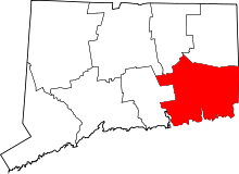
| Region | Southeastern Connecticut | |
| Incorporated | 1687 | |
| Government | ||
| • Type | Selectman-town meeting | |
| • First selectman | Robert M. Congdon (R) | |
| • Selectman | Michael Sinko (R) | |
| • Selectman | Lynwood Crary (D) | |
| Area | ||
| • Total | 31.8 sq mi (82.4 km2) | |
| • Land | 30.9 sq mi (80.0 km2) | |
| • Water | 0.9 sq mi (2.2 km2) | |
| Elevation | 177 ft (54 m) | |
| Population (2010) | ||
| • Total | 4,726 | |
| • Density | 150/sq mi (57/km2) | |
| Time zone | Eastern (UTC-5) | |
| • Summer (DST) | Eastern (UTC-4) | |
| ZIP code | 06365 | |
| Area code(s) | 860 | |
| FIPS code | 09-62150 | |
| GNIS feature ID | 0213492 | |
| Website |
www | |
Preston is a town in New London County, Connecticut, United States. The population was 4,726 at the 2010 census.[1] The town includes the villages of Long Society, Preston City, and Poquetanuck.
History
In 1686, Thomas Parke, Thomas Tracy, and several others petitioned for and were granted by the Connecticut General Court authority to establish a plantation seven miles square to the east of Norwich and north of New London and Stonington. Owaneco, son of the Mohegan sachem Uncas, gave a confirmatory deed for the land in 1687. In October of that same year, the town was formally incorporated as Preston, named for the English city of Preston, Lancashire.[2][3]
The Ecclesiastical Society of Preston was first organized in 1698, with the first meetinghouse located in present-day Preston City. At the request of residents in the northern part of Preston (now the town of Griswold), the North Society was established in 1716. A splinter group, the Separate Church of Preston, was established in 1747 and continued until 1817. The Preston City Baptist Church (now the Preston City Bible Church) was established in 1812.[4][5]
On August 4, 1954, an Air France Lockheed L-1049C Super Constellation flying from Orly Airport to Idlewild Airport crashed near Preston.[6]
Geography
According to the United States Census Bureau, the town has a total area of 31.8 square miles (82 km2), of which 30.9 square miles (80 km2) is land and 0.9 square miles (2.3 km2), or 2.71%, is water.
Principal communities
There were three distinct settlements in the town when it was first established:[7]
Other minor communities and geographic locations in the town are Hallville, Happyland, and Preston Plains.
Demographics
| Historical population | |||
|---|---|---|---|
| Census | Pop. | %± | |
| 1820 | 1,899 | — | |
| 1850 | 1,842 | — | |
| 1860 | 2,092 | 13.6% | |
| 1870 | 2,161 | 3.3% | |
| 1880 | 2,523 | 16.8% | |
| 1890 | 2,555 | 1.3% | |
| 1900 | 2,807 | 9.9% | |
| 1910 | 1,917 | −31.7% | |
| 1920 | 2,743 | 43.1% | |
| 1930 | 3,928 | 43.2% | |
| 1940 | 4,206 | 7.1% | |
| 1950 | 1,775 | −57.8% | |
| 1960 | 4,992 | 181.2% | |
| 1970 | 3,593 | −28.0% | |
| 1980 | 4,644 | 29.3% | |
| 1990 | 5,006 | 7.8% | |
| 2000 | 4,688 | −6.4% | |
| 2010 | 4,726 | 0.8% | |
| Est. 2014 | 4,748 | [8] | 0.5% |
As of the census[10] of 2000, there were 4,688 people, 1,837 households, and 1,359 families residing in the town. The population density was 151.7 people per square mile (58.6/km²). There were 1,901 housing units at an average density of 61.5 per square mile (23.8/km²). The racial makeup of the town was 95.63% White, 0.75% African American, 0.83% Native American, 1.15% Asian, 0.02% Pacific Islander, 0.51% from other races, and 1.11% from two or more races. Hispanic or Latino of any race were 1.39% of the population.
There were 1,837 households out of which 30.3% had children under the age of 18 living with them, 62.9% were married couples living together, 7.0% had a female householder with no husband present, and 26.0% were non-families. 21.0% of all households were made up of individuals and 8.1% had someone living alone who was 65 years of age or older. The average household size was 2.55 and the average family size was 4.95.
In the town the population was spread out with 22.4% under the age of 18, 5.9% from 18 to 24, 29.4% from 25 to 44, 28.3% from 45 to 64, and 14.0% who were 65 years of age or older. The median age was 41 years. For every 100 females there were 100.1 males. For every 100 females age 18 and over, there were 100.1 males.
The median income for a household in the town was $54,942, and the median income for a family was $62,554. Males had a median income of $44,053 versus $28,226 for females. The per capita income for the town was $24,752. About 1.6% of families and 3.3% of the population were below the poverty line, including 1.5% of those under age 18 and 5.5% of those age 65 or over.
Education
According to the Preston Historical Society, "Schools were built in 'districts' to serve the local children, until two central schools, one on Poquetanuck and one in Preston City were built between 1938 and 1940."[7] Currently, public education in Preston is administered by Preston Public Schools, which operates the Preston Veterans' Memorial School (Pre-K to Grade 5) and the Preston Plains Middle School (Grades 6-8). For high school, students go to multiple school districts of surrounding towns, including the Norwich Free Academy, Ledyard High School, Grasso Tech, Norwich Tech, Marine Science Magnet High School, and Science and Tech Magnet High School in New London, CT.
Notable locations
- Strawberry Park is located within Preston.
On the National Register of Historic Places
- Hallville Mill Historic District — Hallville Road, Hall's Mill Road, and Route 2A on Hallville Pond (added September 22, 1996)
- Long Society Meetinghouse — built in 1819 on the site of an earlier meetinghouse and added to the National Register of Historic Places in 1976.
- Poquetanuck Village Historic District — Roughly along Main Street between Route 117 and Middle Road and along School House and Cider Mill Road (added September 22, 1996)
- Preston City Historic District — Amos and Old Shetucket Roads, Northwest Corner Road, and Route 164 (added August 31, 1987)
Notable people
- Nathan Belcher (1813–1891), lawyer, Connecticut state senator, and US congressman, born in Preston
- Jonathan Brewster (1593–1659), buried in Preston
- Isaac E. Crary (1804–1854), the first elected congressman from the state of Michigan, born in Preston[11]
- William Howard Doane (1831–1915), industrialist and composer
- Beriah Green (1795–1874), abolitionist and author born in Preston
- Clarence Ellis Harbison (1885–1960), animal psychologist who lived his later life and died in Preston
- John Haskell Hewitt (1835–1920), classical scholar and professor born in Preston
- George D. Prentice (1802–1870), controversial newspaper editor born in town
- Henry Brewster Stanton (1805–1887), abolitionist, social reformer and husband of Elizabeth Cady Stanton; born in town
- George A. Starkweather (1794–1879), congressman for New York, born in Preston
- Henry H. Starkweather (1826–1876), postmaster and congressman born in Preston
- Joseph Steward (1753–1822), artist who studied and lived in Preston
References
- ↑ "Profile of General Population and Housing Characteristics: 2010 Demographic Profile Data (DP-1): Preston town, New London County, Connecticut". U.S. Census Bureau, American Factfinder. Retrieved October 26, 2012.
- ↑ F.M. Caulkins, History of Norwich, (Thomas Robinson, 1845)
- ↑ Connecticut Colony Public Records, Vol. III
- ↑ Connecticut Colony Public Records, Vol. IV
- ↑ Preston. First Congregational Church. The Bicentennial Celebration
- ↑ http://select.nytimes.com/gst/abstract.html?res=F00F10FA3E55117A93C6A91783D85F408585F9
- 1 2 About Preston, Town of Preston website, accessed September 9, 2009
- ↑ "Annual Estimates of the Resident Population for Incorporated Places: April 1, 2010 to July 1, 2014". Retrieved June 4, 2015.
- ↑ "Census of Population and Housing". Census.gov. Retrieved June 4, 2015.
- ↑ "American FactFinder". United States Census Bureau. Retrieved 2008-01-31.
- ↑ "CRARY, Isaac Edwin, (1804 - 1854)". Biographical Directory of the United States Congress. Retrieved October 10, 2012.