Hebron, Connecticut
| Hebron, Connecticut | ||
|---|---|---|
| Town | ||
|
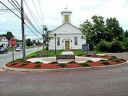
Old Town Hall | ||
| ||
| Motto: "Historic Charm...with a Vision for the Future"[1] | ||
 Location within Tolland County, Connecticut | ||
| Coordinates: 41°39′N 72°23′W / 41.650°N 72.383°WCoordinates: 41°39′N 72°23′W / 41.650°N 72.383°W | ||
| Country | United States | |
| State | Connecticut | |
| NECTA | Hartford | |
| Region | Capitol Region | |
| Incorporated | 1708 | |
| Government | ||
| • Type | Board of selectmen/Town Manager | |
| • First selectman | Daniel E. Larson (R) | |
| • Selectmen |
Clara O'Brien (R) Gail B. Richmond (R) Brian O'Connell (D) Mark Stuart (D) | |
| • Town Manager | Andrew Tierney | |
| Area | ||
| • Total | 37.3 sq mi (96.6 km2) | |
| • Land | 36.9 sq mi (95.6 km2) | |
| • Water | 0.4 sq mi (0.9 km2) | |
| Elevation | 505 ft (154 m) | |
| Population (2010)[2] | ||
| • Total | 9,686 | |
| • Density | 249/sq mi (96/km2) | |
| Time zone | Eastern (UTC-5) | |
| • Summer (DST) | Eastern (UTC-4) | |
| ZIP code | 06231, 06248 | |
| Area code(s) | 860 | |
| FIPS code | 09-37910 | |
| GNIS feature ID | 0213445 | |
| Website |
www | |

Hebron is a town in Tolland County, Connecticut, United States. The population was 9,686 at the 2010 census. Hebron was incorporated May 26, 1708. In 2010, Hebron was rated #6 in Top Towns in Connecticut, according to Connecticut Magazine.[3]
The villages of Hebron Center, Gilead and Amston are located within Hebron. Amston has its own postal ("zip") code and post office. The remnants of two long since abandoned communities, Grayville and Gay City, are also located in Hebron. The site of the latter is now Gay City State Park.
History
The town of Hebron was settled in 1704, and incorporated on 26 May 1708 within Hartford County from Non-County Area 1.[4] The diamond shape of the town seal has its origins in the diamond figure brand, , required on all horses kept in Hebron by a May 1710 act of the Colonial Assembly.[5]

Hebron became a town in Windham County upon its formation on 12 May 1726. It became a town in Tolland County upon its formation from part of Windham County on 13 October 1785.[6] On 13 October 1803 the town of Marlborough, Hartford County was created from parts of the towns of Colchester (New London County), Glastonbury (Hartford County), and Hebron.[7]
Geography
According to the United States Census Bureau, the town has a total area of 37.3 square miles (97 km2), of which, 36.9 square miles (96 km2) of it is land and 0.4 square miles (1.0 km2) of it (0.97%) is water.
Demographics
| Historical population | |||
|---|---|---|---|
| Census | Pop. | %± | |
| 1820 | 2,094 | — | |
| 1850 | 1,345 | — | |
| 1860 | 1,425 | 5.9% | |
| 1870 | 1,279 | −10.2% | |
| 1880 | 1,243 | −2.8% | |
| 1890 | 1,039 | −16.4% | |
| 1900 | 1,016 | −2.2% | |
| 1910 | 894 | −12.0% | |
| 1920 | 915 | 2.3% | |
| 1930 | 879 | −3.9% | |
| 1940 | 999 | 13.7% | |
| 1950 | 1,320 | 32.1% | |
| 1960 | 1,819 | 37.8% | |
| 1970 | 3,815 | 109.7% | |
| 1980 | 5,453 | 42.9% | |
| 1990 | 7,079 | 29.8% | |
| 2000 | 8,610 | 21.6% | |
| 2010 | 9,686 | 12.5% | |
| Est. 2014 | 9,564 | [8] | −1.3% |
As of the census[10] of 2000, there were 8,610 people, 2,993 households, and 2,466 families residing in the town. The population density was 233.3 people per square mile (90.1/km²). There were 3,110 housing units at an average density of 84.3 per square mile (32.5/km²). The racial makeup of the town was 97.69% White, 0.58% African American, 0.13% Native American, 0.56% Asian, 0.03% Pacific Islander, 0.20% from other races, and 0.81% from two or more races. Hispanic or Latino of any race were 1.07% of the population.
There were 2,993 households out of which 45.1% had children under the age of 18 living with them, 74.4% were married couples living together, 5.9% had a female householder with no husband present, and 17.6% were non-families. 13.4% of all households were made up of individuals and 4.2% had someone living alone who was 65 years of age or older. The average household size was 2.88 and the average family size was 3.19.
In the town the population was spread out with 30.0% under the age of 18, 4.6% from 18 to 24, 33.7% from 25 to 44, 25.7% from 45 to 64, and 6.0% who were 65 years of age or older. The median age was 37 years. For every 100 females there were 100.1 males. For every 100 females age 18 and over, there were 97.2 males.
The median income for a household in the town was $101,905. Males had a median income of $52,209 versus $42,257 for females. The per capita income for the town was $39,775. About 0.6% of families and 1.4% of the population were below the poverty line, including 0.2% of those under age 18 and 4.5% of those age 65 or over.
| Voter Registration and Party Enrollment as of October 27, 2009[11] | |||||
|---|---|---|---|---|---|
| Party | Active Voters | Inactive Voters | Total Voters | Percentage | |
| Democratic | 1,788 | 36 | 1,824 | 27.98% | |
| Republican | 1,539 | 49 | 1,588 | 24.36% | |
| Unaffiliated | 2,995 | 101 | 3,096 | 49.49% | |
| Minor Parties | 10 | 1 | 11 | 0.17% | |
| Total | 6,332 | 187 | 6,519 | 100% | |
Economy
Hebron was recently ranked the sixth top Connecticut town, and Hebron's website describes it as "a quaint Connecticut town."
Arts and culture
Annual cultural events
A major commercial attraction is the annual Hebron Harvest Fair, which features bingo, fried foods, rides, prizes, arts & crafts, pig races, tractor pulls, prizes for the best pies and the biggest pumpkins. The event occurs every September. This event is not only for the people of Hebron, but also for many tourists visiting the town.
Parks and recreation
Hebron's most popular year-round recreation area is Gay City State Park, Connecticut's second-largest State Park. There is a 5-mile perimeter trail and an extensive network of cross trails that run throughout the park. All are suitable for woodland hiking and trail biking. Gay City also has a pond in which swimming is available in season, fishing, picnic areas, cross-country skiing and snowshoeing.
In addition, Hebron has several town parks and ballfields, and the Town Recreation Department has organized sports and other activities throughout the year. The rails-to-trails Airline Trail State Park goes through Hebron, with several access points for walkers, bikers and horseback riders.
Education
The town hosts the regional middle and high schools for two adjacent towns, Marlborough and Andover. RHAM High School is ranked one of the top high schools in the state.
Notable people
- Frank Aresti - (1967-) - Guitarist, Fates Warning.
- Mark Allen Baker - (1957-) - Author, biographer & historian
- William A. Palmer - (1781–1860) - US Senator and Governor of Vermont.
- John Samuel Peters, (1772–1858) - 26th Governor of Connecticut.
- A. J. Pollock (1987-), - Outfielder, Arizona Diamondbacks.
- Christopher Larkin(1987-) (Actor/Singer/Songwriter)
- Robert Williams, (1833 - 6 March 1854) US Marine private who died while serving on the USS Mississippi during the Perry Expedition. Final resting place Gyokusen-ji, Shimoda, Japan.[12][13]
References
- ↑ "Town of Hebron Connecticut". Town of Hebron Connecticut. Retrieved September 22, 2012.
- ↑ U.S. Census Bureau Population Estimates
- ↑ "Rating the Towns 2010 Population". connecticutmag.com. Retrieved March 2010. Check date values in:
|access-date=(help) - ↑ Conn. Col. Recs., 5:64.
- ↑ Conn.Col.Records, 5:158
- ↑ "Windham County Chronology". Retrieved January 7, 2013.
- ↑ Conn. Spec. Acts 1803, 2:1157-1158.
- ↑ "Annual Estimates of the Resident Population for Incorporated Places: April 1, 2010 to July 1, 2014". Retrieved June 4, 2015.
- ↑ "Census of Population and Housing". Census.gov. Retrieved June 4, 2015.
- ↑ "American FactFinder". United States Census Bureau. Retrieved 2008-01-31.
- ↑ "Registration and Party Enrollment Statistics as of October 27, 2009" (PDF). Connecticut Secretary of State. Retrieved 2010-07-16.
- ↑ Daugherty, Leo (2009). The Marine Corps and the State Department. Jefferson, North Carolina: McFarland & Company Inc. p. 19. ISBN 978-0-7864-3796-2.
- ↑ Cary, Otis (1909). A History of Christianity in Japan. New York: Fleming H. Revell Company. p. 32.
External links
| Wikimedia Commons has media related to Hebron, Connecticut. |
- Town of Hebron Connecticut Portal style website, Government, Business, Library, Recreation and more
- Hebron Historical Society
- Douglas Library
Municipalities and communities of Tolland County, Connecticut, United States | ||
|---|---|---|
| Towns | 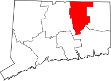 | |
| Other communities | ||