Goudourville
| Goudourville | ||
|---|---|---|
|
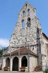
The church of Saint-Julien-de-Brioude, in Goudourville | ||
| ||
 Goudourville | ||
|
Location within Occitanie region  Goudourville | ||
| Coordinates: 44°06′55″N 0°55′46″E / 44.1153°N 0.9294°ECoordinates: 44°06′55″N 0°55′46″E / 44.1153°N 0.9294°E | ||
| Country | France | |
| Region | Occitanie | |
| Department | Tarn-et-Garonne | |
| Arrondissement | Castelsarrasin | |
| Canton | Valence | |
| Intercommunality | Deux Rives | |
| Government | ||
| • Mayor (2008–2014) | Jean-Pierre Parisse | |
| Area1 | 11.27 km2 (4.35 sq mi) | |
| Population (2006)2 | 923 | |
| • Density | 82/km2 (210/sq mi) | |
| Time zone | CET (UTC+1) | |
| • Summer (DST) | CEST (UTC+2) | |
| INSEE/Postal code | 82073 / 82400 | |
| Elevation |
57–182 m (187–597 ft) (avg. 130 m or 430 ft) | |
|
1 French Land Register data, which excludes lakes, ponds, glaciers > 1 km² (0.386 sq mi or 247 acres) and river estuaries. 2 Population without double counting: residents of multiple communes (e.g., students and military personnel) only counted once. | ||
.svg.png)
Goudourville is a commune in the Tarn-et-Garonne department in the Occitanie region in southern France.
Geography
The Barguelonne forms all of the commune's northern border.
See also
References
| Wikimedia Commons has media related to Goudourville. |
This article is issued from Wikipedia - version of the 11/12/2016. The text is available under the Creative Commons Attribution/Share Alike but additional terms may apply for the media files.