Castéra-Bouzet
| Castéra-Bouzet | |
|---|---|
|
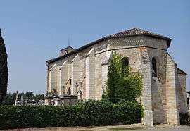
The church of Saint-Barthélemy, in Castéra-Bouzet | |
 Castéra-Bouzet | |
|
Location within Occitanie region  Castéra-Bouzet | |
| Coordinates: 44°00′05″N 0°55′12″E / 44.0014°N 0.92°ECoordinates: 44°00′05″N 0°55′12″E / 44.0014°N 0.92°E | |
| Country | France |
| Region | Occitanie |
| Department | Tarn-et-Garonne |
| Arrondissement | Castelsarrasin |
| Canton | Lavit |
| Intercommunality | Lomagne Tarn-et-Garonnaise |
| Government | |
| • Mayor (2001–2008) | Jean-Luc Colonna |
| Area1 | 17.75 km2 (6.85 sq mi) |
| Population (2006)2 | 119 |
| • Density | 6.7/km2 (17/sq mi) |
| Time zone | CET (UTC+1) |
| • Summer (DST) | CEST (UTC+2) |
| INSEE/Postal code | 82034 / 82120 |
| Elevation |
95–215 m (312–705 ft) (avg. 217 m or 712 ft) |
|
1 French Land Register data, which excludes lakes, ponds, glaciers > 1 km² (0.386 sq mi or 247 acres) and river estuaries. 2 Population without double counting: residents of multiple communes (e.g., students and military personnel) only counted once. | |
Castéra-Bouzet is a commune in the Tarn-et-Garonne department in the Occitanie region in southern France.
See also
References
| Wikimedia Commons has media related to Castéra-Bouzet. |
This article is issued from Wikipedia - version of the 11/12/2016. The text is available under the Creative Commons Attribution/Share Alike but additional terms may apply for the media files.