Varen, Tarn-et-Garonne
| Varen | |
|---|---|
|
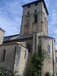
The church of Saint-Pierre, in Varen | |
 Varen | |
|
Location within Occitanie region  Varen | |
| Coordinates: 44°09′33″N 1°53′42″E / 44.1592°N 1.895°ECoordinates: 44°09′33″N 1°53′42″E / 44.1592°N 1.895°E | |
| Country | France |
| Region | Occitanie |
| Department | Tarn-et-Garonne |
| Arrondissement | Montauban |
| Canton | Saint-Antonin-Noble-Val |
| Intercommunality | Quercy Rouergue et des Gorges de l'Aveyron |
| Government | |
| • Mayor (2008–2014) | André Massat |
| Area1 | 23.13 km2 (8.93 sq mi) |
| Population (2006)2 | 744 |
| • Density | 32/km2 (83/sq mi) |
| Time zone | CET (UTC+1) |
| • Summer (DST) | CEST (UTC+2) |
| INSEE/Postal code | 82187 / 82330 |
| Elevation |
118–372 m (387–1,220 ft) (avg. 160 m or 520 ft) |
|
1 French Land Register data, which excludes lakes, ponds, glaciers > 1 km² (0.386 sq mi or 247 acres) and river estuaries. 2 Population without double counting: residents of multiple communes (e.g., students and military personnel) only counted once. | |
Varen is a commune in the Tarn-et-Garonne department in the Occitanie region in southern France.
See also
References
| Wikimedia Commons has media related to Varen (Tarn-et-Garonne). |
This article is issued from Wikipedia - version of the 11/12/2016. The text is available under the Creative Commons Attribution/Share Alike but additional terms may apply for the media files.