Saint-Nazaire-de-Valentane
| Saint-Nazaire-de-Valentane | |
|---|---|
|
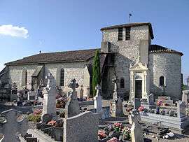
The church of Saint-Nazaire, in Saint-Nazaire-de-Valentane | |
 Saint-Nazaire-de-Valentane | |
|
Location within Occitanie region  Saint-Nazaire-de-Valentane | |
| Coordinates: 44°13′22″N 1°00′46″E / 44.2229062°N 1.0126734°ECoordinates: 44°13′22″N 1°00′46″E / 44.2229062°N 1.0126734°E | |
| Country | France |
| Region | Occitanie |
| Department | Tarn-et-Garonne |
| Arrondissement | Castelsarrasin |
| Canton | Bourg-de-Visa |
| Government | |
| • Mayor (2008–2014) | Roger Lacombe |
| Area1 | 17.44 km2 (6.73 sq mi) |
| Population (2008)2 | 331 |
| • Density | 19/km2 (49/sq mi) |
| Time zone | CET (UTC+1) |
| • Summer (DST) | CEST (UTC+2) |
| INSEE/Postal code | 82168 / 82190 |
| Elevation |
74–207 m (243–679 ft) (avg. 200 m or 660 ft) |
|
1 French Land Register data, which excludes lakes, ponds, glaciers > 1 km² (0.386 sq mi or 247 acres) and river estuaries. 2 Population without double counting: residents of multiple communes (e.g., students and military personnel) only counted once. | |
Saint-Nazaire-de-Valentane is a commune in the Tarn-et-Garonne département in the Occitanie region in southern France.
Geography
The Barguelonne forms all of the commune's southeastern border.
See also
References
| Wikimedia Commons has media related to Saint-Nazaire-de-Valentane. |
This article is issued from Wikipedia - version of the 11/12/2016. The text is available under the Creative Commons Attribution/Share Alike but additional terms may apply for the media files.