Sainte-Juliette
| Sainte-Juliette | |
|---|---|
|
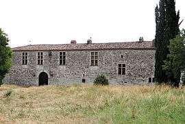
The Château de la Barathie, in Sainte-Juliette | |
 Sainte-Juliette | |
|
Location within Occitanie region  Sainte-Juliette | |
| Coordinates: 44°17′15″N 1°10′12″E / 44.2875°N 1.17°ECoordinates: 44°17′15″N 1°10′12″E / 44.2875°N 1.17°E | |
| Country | France |
| Region | Occitanie |
| Department | Tarn-et-Garonne |
| Arrondissement | Castelsarrasin |
| Canton | Lauzerte |
| Intercommunality | Quercy Pays de Serres |
| Government | |
| • Mayor (2001–2008) | Agnès Palmié |
| Area1 | 7.3 km2 (2.8 sq mi) |
| Population (2006)2 | 118 |
| • Density | 16/km2 (42/sq mi) |
| Time zone | CET (UTC+1) |
| • Summer (DST) | CEST (UTC+2) |
| INSEE/Postal code | 82164 / 82110 |
| Elevation |
115–243 m (377–797 ft) (avg. 100 m or 330 ft) |
|
1 French Land Register data, which excludes lakes, ponds, glaciers > 1 km² (0.386 sq mi or 247 acres) and river estuaries. 2 Population without double counting: residents of multiple communes (e.g., students and military personnel) only counted once. | |
Sainte-Juliette is a commune in the Tarn-et-Garonne department in the Occitanie region in southern France.
Geography
The Barguelonnette flows southwestward through the commune.
See also
References
| Wikimedia Commons has media related to Sainte-Juliette. |
This article is issued from Wikipedia - version of the 11/12/2016. The text is available under the Creative Commons Attribution/Share Alike but additional terms may apply for the media files.