Milan Township, Allen County, Indiana
| Milan Township | |
|---|---|
| Township | |
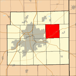 Location in Allen County, Indiana | |
| Coordinates: 41°08′17″N 84°56′54″W / 41.13806°N 84.94833°WCoordinates: 41°08′17″N 84°56′54″W / 41.13806°N 84.94833°W | |
| Country |
|
| State |
|
| County | Allen |
| Government | |
| • Type | Indiana township |
| Area | |
| • Total | 37.49 sq mi (97.09 km2) |
| • Land | 37.18 sq mi (96.29 km2) |
| • Water | 0.31 sq mi (0.80 km2) 0.83% |
| Elevation | 758 ft (231 m) |
| Population (2010) | |
| • Total | 3,749 |
| • Density | 101/sq mi (38.9/km2) |
| ZIP codes | 46741, 46774, 46797, 46835 |
| GNIS feature ID | 0453624 |
Milan Township is one of twenty townships in Allen County, Indiana, United States. Milan Township is located in east central Allen County, with the Maumee River meandering across the township. As of the 2010 census, its population was 3,749.[1] The township is highly rural, with only 1,137 houses in the 2010 census.[1]> Many of the residents of Milan Township are Amish.
Overview
Milan township is generally demarcated by Schwartz Road to the west, Notestine Road to the north, Sampson Road to the east, and Gar Creek Road to the south.
The principal town in Milan Township is Milan Center, at 41°8'39"N 84°56'46"W. Milan Center lies at the intersection of Milan Center Road and Doty Road, and at an earlier time consisted of Brueggeman's (a combination lumberyard, hardware and grocery store), a small wood-frame church, Milan Center School, a feed mill, and four houses.
In the mid-20th century, telephone communication across relatively short distances could be prohibitively expensive. Northern Milan township had traditionally been served by the Harlan telephone exchange, and southern Milan township by the New Haven telephone exchange. To make a call between differing exchanges, one could incur so-called "long distance" surcharges. Brueggeman's store at Milan Center served as a progressive business and community center by having telephones from both exchanges. The New Haven telephone exchange was purchased by the Home Telephone company in Fort Wayne, which was itself subsequently acquired by General Telephone of Indiana. The Harlan telephone company was also eventually acquired by General Telephone of Indiana. General Telephone is now a part of Verizon.
Brueggeman's Do-It-Best Center subsequently left to build a new store several miles removed to take advantage of traffic on State Highway 37 (at Ricker Road). The original Milan Center structure subsequently was lost to fire, and the relocated Brueggeman's closed April 12, 2014 after 100 years of business.
The Milan Township and Maumee Township (city of Woodburn) school districts cooperatively built and dedicated Woodlan High School for the 1959-1960 school year. Located in Milan Township, the school lies just east of Five Points on the Woodburn Road. Harlan High students began attending circa 1965, as the schools had been consolidated into the East Allen County School district a year earlier. Junior high and elementary schools are also now located on the campus.
Five Points is a settlement located at the junction of Old US Highway 24, Webster Road, and Woodburn Road, along the old Wabash-Erie Canal route. At one time it consisted of a small diner for truckers, a gas station (later a bicycle shop), a tile mill, and a few homes. A newer water tower labeled "Woodlan" near Woodlan School may result in the community being known as "Woodlan" in the coming years.
Gar Creek was once a shipping point on the Wabash and Toledo Railroad. A small community of 500 people eventually settled around the station. The 1882-1883 Indiana State Gazetteer and Business Directory published by R.L. Polk & Company, stated that lumber and grain were the primary exports of the station. Gar Creek enterprises listed at that time included a shingle manufacturer, two carpenters, a Justice of the Peace, a saw mill, a general store with a railway agent and a Postmaster (Jesse Rothgeb), a blacksmith, a hoop manufacturer, and United Brethren and Lutheran churches. The population at that time was listed as 130.
Thurman was a settlement located on the Detroit branch of the old Wabash Railroad. A few homes and businesses remain to this day.
Geography
According to the United States Census Bureau, Milan Township covers an area of 37.49 square miles (97.09 km2); of this, 37.18 square miles (96.29 km2) is land and 0.31 square miles (0.80 km2), or 0.83%, is water.[1]
Unincorporated towns
- Five Points at 41°07′24″N 84°56′25″W / 41.123382°N 84.940244°W
- Milan Center at 41°08′39″N 84°56′46″W / 41.144216°N 84.946077°W
- Thurman at 41°07′17″N 85°00′07″W / 41.121308°N 85.0019815°W
- Gar Creek at 41°05′41″N 84°57′09″W / 41.094751°N 84.952513°W
(This list is based on USGS data and may include former settlements.)
Adjacent townships
- Springfield Township (northeast)
- Maumee Township (east)
- Jackson Township (southeast)
- Jefferson Township (south)
- Adams Township (southwest)
- St. Joseph Township (west)
- Cedar Creek Township (northwest)
Cemeteries
- Amish Cemetery, located at 14702 Doty Road, behind the Amish School, about a half mile west of Milan Center.
- Barnett Chapel Cemetery, located on the northwest corner of State Road 37 (Maysville Turnpike) and Barnett Road. Lutheran. Earliest date 1875.
- Gar Creek Union Cemetery, located on the Gar Creek Road, 0.3 miles east of the Berthaud Road. Private. Earliest date December 23, 1884.
- Irving Family Cemetery, located on the south bank of the Maumee River, north of the B.F. Goodrich Tire Plant, on U.S. 24, on Goodrich land. Earliest date 1847.
- Platter Family Cemetery, located 0.2 miles south of the Platter Bridge on the northeast bank of the Maumee River. One stone: 1852.
- Saint Paul's Lutheran Cemetery at Gar Creek, located next to the church on Berthaud Road, about 0.2 miles south of Bremer Road. Earliest date 1884.
- Schwartz Family Cemetery, located on the north side of Irving Road 0.1 mile east of the Bruick Road. Amish. No markers.
This information is from the Allen County INGenWeb Project at http://www.acgsi.org/genweb/cemeteries/milan-township-cemeteries-allen-county-indiana.html retrieved 11/18/2015.
Historically significant churches
- Milan Evangelical Lutheran Church (Barnett Chapel) and Cemetery at State Road 37 and Barnett Road. Organized in 1864. Merged with St. Mark's Lutheran Church, Harlan (Springfield Township) in 1921. Now part of Holy Trinity Lutheran Church (see Springfield Township).
- St. Paul's Evangelical Lutheran Church-Gar Creek and Cemetery at 1910 N. Berthaud Road. Organized in 1880 by members of Emanuel Evangelical Lutheran Church, New Haven. Birth, baptism, confirmation, marriage and death records exist since 1880. Early records in German. Records have been photocopied and are available at the Allen County Public Library.
- Milan Center Methodist Protestant Church at the corner of Doty and Milan Center Roads. Organized in 1905/06 when a series of meetings were held in the old Milan Center schoolhouse. Land was donated and construction on the church was begun in 1906. Church disbanded sometime after 1954. Records may be located at the DePauw University Library, Greencastle, IN. The church building has been utilized by various congregations since.
- The Gar Creek Mennonite Church is also now defunct. In about 1854, Mennonites first settled at Gar Creek, a village 11 miles (18 km) northeast of Fort Wayne, Indiana. Among them Michael Rothgeb, Abram and Jacob Bixler, John Federspiel, Hezekiah Rothgeb, and Nancy Lowery. Services were held in Bethel Chapel, a union building. There was no resident minister. Eli Stoffer, a minister in the Hudson (Indiana) congregation, and others conducted occasional services. In 1900 there were 20 members. After the establishing of the Fort Wayne Mission in 1903, the mission workers assumed responsibility for the services at Gar Creek. On 22 October 1905 the building was rededicated for church services. Regular services were discontinued about 1910.[2]
This information is from the Allen County INGenWeb Project at http://www.acgsi.org/genweb/churches/milan-township-churches-of-allen-county-indiana.html retrieved 11-18-2015.
Other historically significant structures
| Lengacher-Sapp Farm | 17116 Notestine Road | Vernacular |
| Christan Lengacher Farm | 10220 Thimlar Road | 1910 Foursquare, two gambrel roof barns |
| Lake-Lengacher Farm | 15329 State Road 37 | c. 1870 Vernacular Gabled Ell |
| Swifts-Werts Farm | 15039 State Road 37 | c. 1880 Italianate house, Gable barn |
| Harp-Graber Farm | 14510 Notestine Road | Vernacular Gabled Ell and timber-pegged house |
| John Graber Farm | 10108 Graber Road | c. 1890 Vernacular Gabled Ell brick line |
| John Bertsch Farm | 9842 Graber Road | c. 1870 Vernacular Gabled Ell log |
| Peter Graber, Sr House | 9905 Graber Road | c. 1860 I-house log |
| Christian Richer Farm | 9921 Ricker Road | c. 1855 Vernacular log |
| J. E. Motherwell Farm | 9633 Ricker Road | c. 1860 Vernacular log |
| School No 12 (original) | 9127 Ricker Road | c. 1870 Vernacular |
| William Fitzgerald, Sr Farm | 9127 Ricker Road | c. 1870 Timber Frame w/ Greek Revival details |
| Township | School No. 12 30 Ricker Road | 1899 Romanesque Revival |
| Yoder-Ringgenberger-Graber Farm | 8917 Graber Road | c. 1855 Vernacular |
| John Graber Farm | 8918 Graber Road | c. 1910 Vernacular gabled ell timber-pegged barn |
| Summers-Bottern-Graber Farm | 8604 Graber Road | Brick-lined house, hand-hewn log barn |
| Milan Township School No. 1 | 13903 Maysville Road | 1882 Vernacular |
| Chamberlain Settlement | State Road 37 at Bruick Road | c. 1850 |
| Henry Kurtz House | 14106 State Road 37 East | c. 1925 Craftsman bungalow |
| John Kurtz Farm | 14212 State Road 37 East | c. 1914 Foursquare |
| Barnett Chapel Lutheran Cemetery | 14441 State Road 37 East | 1875 |
| M. Sowers House | 14441 State Road 37 East | c. 1850 Greek Revival |
| Joe Miller Farm & Harness Shop | 76212 Darling Road | c. 1910 Vernacular gabled ell of tile block |
| Noah Miller Farm | 16315 Darling Road | c. 1855 Vernacular log house, German four-bay barn |
| Township School No. 6 | 17985 Darling Road | c. 1880 Other |
| W. A. Ward House | 18928 Ward Road | c. 1910 Colonial Revival |
| A. Devauz Farm | 7913 Brush College Road | c. 1905 East Lake |
| Wm. F. Ehle Farm | 15729 Ehle Road | Rebuilt 1926 House; 1880s Craftsman house, early gabled barn |
| John Thimlar Farm | 15001 Ehle Road | c. 1860 Vernacular Log House |
| George Washington T. Safford Farm | 7907 Bruick Road | c. 1878 Victorian Gothic |
| Thoddeus B. Stene Farm | 13515 State Road 37 | c. 1870 Vernacular Upright and Wing |
| Daniel D. Miller Farm | 12914 State Road 37 | c. 1865 Vernacular timber-pegged |
| Knight-Miller Farm | 12810 State Road 37 | Vernacular timber-pegged I house |
| Absolom Stateufer Farm | 12610 Doty Road | c. 1880 Italianate |
| David Schwartz Farm | 14030 Doty Road | c. 1875 Vernacular gabled ell |
| Milan Township Amish School | 14083 Doty Road | c. 1950 Vernacular |
| Wm. A. Spindler Farm | 14201 Doty Road | c. 1875 Victorian Gothic |
| George G. Nuttle Farm | 14802 Doty Road | c. 1875 Vernacular: I House |
| J. M. Yerkes Farm | 15208 Doty Road | c. 1890 House estate |
| Milan Center School | Doty Road at Milan Center Road | c. 1900 Romanesque Revival |
| Milan Center Methodist Church | NW Corner Milan Center & Doty Road | c. 1901 |
| Brueggemann's General Store | 15303 Doty Road | c. 1924 2-story, 1928 Craftsman |
| Milan Center Feed Mill | 15402 Doty Road | c. 1946 other |
| Theodore Thimlar House | 16026 Doty Road | c. 1892 Italianate |
| Milan Township School No. 7 | Doty Road at Brush College (NE corner) | 1902 Classical Revival |
| Canal Tavern House | 19524 U.S. 24 | c. 1850 Vernacular log |
| Irving Family Cemetery | 18907 E. U.S. 24 | c. 1847 |
| Fairport Settlement | U.S. 24 A/C from Goodrich Uniroyal Plant N-side | 1837 |
| Sanford A. Ransom Farm | 6034 Milan Center Road | c. 1870 Vernacular vertical plank-lined |
| Christian Schwartz Farm a | 14422 Irving Road | c. 1870 Vernacular I house |
| John Schwartz Farm | 14218 Irving Road | 1870 Vernacular I house |
| Schwartz Family Cemetery | 13935 Irving Road | 19th century-early 20th century |
| J. J. Schwartz Farm | 5229-35 Bruick Road | c. 1870 Vernacular log |
| Platter Family Cemetery | S. of Webster Road E. of Maumee River | c. 1852 |
| Summerset (town) | S. Bank of Maumee River near Webster Road | |
| Shaney Brooks (or local surname Shanebrook?) Gas Station | 16800 E. Woodburn Road | c. 1920 Craftsman |
| Five Points/Canal Turnaround | US 24 at Webster & Woodburn Road. | 1920 Craftsman |
| Henry Busche Farm | 4029 Sampson Road | c. 1870 Vernacular log |
| Peter Schaaf Farm | 3637 Webster Road | c. 1872 Victorian Gothic |
| William P. Bruick Farm | 15019 Parent Road | c. 1870 Vernacular gabled ell |
| George Peter Schlink Farm | 14218 Parent Road | 1879 Italianate |
| Hemsoth-Metert Farm | 12830 Stellhorn Road | c. 1870 Queen Anne |
| Hemrich Nietert Farm | 3534 Ricker Road | 1885 Italianate |
| Wm. Schafer Farm | 3814 Ricker Road | 1875 Vernacular wing, gabled front |
| Gottlieb Schafer Barn & Outbuildings | 12015 Stellhorn Road | 1893 1893 Bank barn |
| Henry Meyer Farm | 11604 Stellhorn Road | 1875 Vernacular: I house |
| Village of Thurman | 10800 E Stellhorn Road at 4400 N Thurman, E to RR tracks | Early 20th-century village |
| H. Kuehn Farm | 10930 Stellhorn Road | Vernacular |
| Vonderau Farm | 3714 Thurman Road | c. 1910 Dutch Colonial Revival |
| Bowers Mill | 11500 Parent Road at Bride N-side | c. 1861 Vernacular water-powered mill |
| Henry Nahrwold Farm | 11013 Parent Road | 1875 Vernacular gabled Front |
| Lapp-Vonderau Farm | 11102 Stellhorn Road | 1900 Victorian Gothic |
| Young-Hermann Farm | 11418 Parent Road | 1890 East Lake |
| Heinrich Bischoff Farm | 11618 Parent Road | c. 1880 Queen Anne |
| Hiram Parent Farm | 12808 Parent Road | c. 1875 Italianate |
| John Harper Farm | 13086 Bremer Road | 1870 Vernacular gabled ell |
| Charles Hockemeyer Farm | 14216 Bremer Road | 1911-12 Classical Revival |
| State Paul's Lutheran Church Cemetery | 1910 Berthaud Road Milan | |
| Herman & Christine Meyer Farm | 15503 Gar Creek Road | p. 1900 Foursquare with Colonial Revival detail |
| Gar Creek Union Cemetery | 15715 Gar Creek Road | 1884 |
| Mosler Village | 17703 Bremer Road N. of RR Tracks and Road | 1854 |
| Gar Creek Settlement | 16221 Gar Creek Road |
Major highways
Airports and landing strips
- Airpark Field
School districts
- East Allen County Schools
Political districts
- Indiana's 3rd congressional district
- State House District 79
- State House District 85
- State Senate District 14
References
- United States Census Bureau 2008 TIGER/Line Shapefiles
- United States Board on Geographic Names (GNIS)
- IndianaMap
- 1 2 3 "Geographic Identifiers: 2010 Demographic Profile Data (DP-1): Milan township, Allen County, Indiana". U.S. Census Bureau, American Factfinder. Retrieved March 26, 2013.
- ↑ Osborne, Hubert L. "Gar Creek Mennonite Church (Gar Creek, Indiana, USA)." Global Anabaptist Mennonite Encyclopedia (Online.) 1956. Retrieved 13 January 2008 <http://www.gameo.org/encyclopedia/contents/G362.html>
External links
 |
Cedar Creek Township | |
Springfield Township | |
| St. Joseph Township | |
Maumee Township | ||
| ||||
| | ||||
| Adams Township | Jefferson Township | Jackson Township |
Municipalities and communities of Allen County, Indiana, United States | ||
|---|---|---|
| Cities | ||
| Towns | ||
| Townships | ||
| CDPs | ||
| Other unincorporated communities |
| |
| Footnotes | ‡This populated place also has portions in an adjacent county or counties | |