Boonville, Indiana
| City of Boonville, Indiana | |
|---|---|
| City | |
|
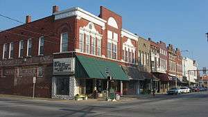
The downtown historic district in Boonville is listed on the National Register of Historic Places | |
 Location in the state of Indiana | |
| Coordinates: 38°2′46″N 87°16′21″W / 38.04611°N 87.27250°WCoordinates: 38°2′46″N 87°16′21″W / 38.04611°N 87.27250°W | |
| Country | United States |
| State | Indiana |
| County | Warrick |
| Township | Boon |
| Government | |
| • Mayor | Charlie Wyatt (D) |
| Area[1] | |
| • Total | 3.01 sq mi (7.80 km2) |
| • Land | 3.00 sq mi (7.77 km2) |
| • Water | 0.01 sq mi (0.03 km2) |
| Elevation[2] | 423 ft (129 m) |
| Population (2010)[3] | |
| • Total | 6,246 |
| • Estimate (2012)[4] | 6,210 |
| • Density | 2,082.0/sq mi (803.9/km2) |
| Time zone | CST (UTC-6) |
| • Summer (DST) | CDT (UTC-5) |
| ZIP code | 47601 |
| Area code | 812 |
| FIPS code[2][5] | 18-06616 |
| GNIS ID[2][5] | 431342 |
| Website |
cityofboonvilleindiana |
Boonville is a city in Boon Township, Warrick County, Indiana, United States. The population was 6,246 at the 2010 census. The city is the county seat of Warrick County.[6]
History
Boonville was founded in 1818 and named for Jesse Boon, father of Ratliff Boon.[7] A post office has been in operation at Boonville since 1820.[8] Boonville was incorporated in 1858.[9]
President Abraham Lincoln studied law in Boonville. When Abraham Lincoln and his family moved from Kentucky to present-day Spencer County in 1816, their homestead was then considered to be within Boonville's Warrick County boundaries. The future president frequently walked to Boonville to borrow books and watch local attorney John Brackenridge argue cases, thus earning Boonville the distinction of being "where Lincoln learned the law."
Points of interest
The Boonville post office contains a casein tempera-on-canvas mural titled Boonville Beginnings, painted in 1941 by Ida Abelman.[10] Murals were produced from 1934 to 1943 in the United States through the Section of Painting and Sculpture, later called the Section of Fine Arts, of the Treasury Department.
The Boonville Public Square Historic District and Old Warrick County Jail are listed on the National Register of Historic Places.[11]
Geography
Boonville is located at 38°2′46″N 87°16′21″W / 38.04611°N 87.27250°W (38.046231, -87.272544).[12]
According to the 2010 census, Boonville has a total area of 3.013 square miles (7.80 km2), of which 3 square miles (7.77 km2) (or 99.57%) is land and 0.013 square miles (0.03 km2) (or 0.43%) is water.[1]
Climate
The climate in this area is characterized by hot, humid summers and generally mild to cool winters. According to the Köppen Climate Classification system, Boonville has a humid subtropical climate, abbreviated "Cfa" on climate maps.[13]
Demographics
| Historical population | |||
|---|---|---|---|
| Census | Pop. | %± | |
| 1850 | 196 | — | |
| 1860 | 621 | 216.8% | |
| 1870 | 1,039 | 67.3% | |
| 1880 | 1,182 | 13.8% | |
| 1890 | 1,881 | 59.1% | |
| 1900 | 2,849 | 51.5% | |
| 1910 | 3,934 | 38.1% | |
| 1920 | 4,451 | 13.1% | |
| 1930 | 4,208 | −5.5% | |
| 1940 | 4,526 | 7.6% | |
| 1950 | 5,092 | 12.5% | |
| 1960 | 4,801 | −5.7% | |
| 1970 | 5,736 | 19.5% | |
| 1980 | 6,300 | 9.8% | |
| 1990 | 6,724 | 6.7% | |
| 2000 | 6,834 | 1.6% | |
| 2010 | 6,246 | −8.6% | |
| Est. 2015 | 6,180 | [14] | −1.1% |
2010 census
As of the 2010 census,[3] there were 6,246 people, 2,549 households, and 1,647 families residing in the city. The population density was 2,082.0 inhabitants per square mile (803.9/km2). There were 2,867 housing units at an average density of 955.7 per square mile (369.0/km2). The racial makeup of the city was 97.7% White, 0.5% African American, 0.2% Native American, 0.1% Asian, 0.4% from other races, and 1.1% from two or more races. Hispanic or Latino of any race were 1.2% of the population.
There were 2,549 households of which 31.3% had children under the age of 18 living with them, 47.0% were married couples living together, 13.5% had a female householder with no husband present, 4.1% had a male householder with no wife present, and 35.4% were non-families. 31.1% of all households were made up of individuals and 15.1% had someone living alone who was 65 years of age or older. The average household size was 2.39 and the average family size was 2.97.
The median age in the city was 39.4 years. 23.3% of residents were under the age of 18; 7.4% were between the ages of 18 and 24; 25.8% were from 25 to 44; 25.4% were from 45 to 64; and 18% were 65 years of age or older. The gender makeup of the city was 46.3% male and 53.7% female.
2000 census
As of the 2000 census,[16] there were 6,834 people, 2,688 households, and 1,854 families residing in the city. The population density was 2,318.9 people per square mile (894.4/km²). There were 2,910 housing units at an average density of 987.4 per square mile (380.9/km²). The racial makeup of the city was 98.51% White, 0.64% African American, 0.20% Native American, 0.12% Asian, 0.01% Pacific Islander, 0.03% from other races, and 0.48% from two or more races. Hispanic or Latino of any race were 0.44% of the population.
There were 2,688 households out of which 32.1% had children under the age of 18 living with them, 52.2% were married couples living together, 12.4% had a female householder with no husband present, and 31.0% were non-families. 27.8% of all households were made up of individuals and 14.7% had someone living alone who was 65 years of age or older. The average household size was 2.45 and the average family size was 2.98.
In the city the population was spread out with 25.2% under the age of 18, 9.3% from 18 to 24, 28.2% from 25 to 44, 21.4% from 45 to 64, and 15.9% who were 65 years of age or older. The median age was 37 years. For every 100 females there were 90.7 males. For every 100 females age 18 and over, there were 84.9 males.
The median income for a household in the city was $34,913, and the median income for a family was $42,096. Males had a median income of $32,264 versus $22,227 for females. The per capita income for the city was $15,869. About 6.5% of families and 9.2% of the population were below the poverty line, including 14.1% of those under age 18 and 7.3% of those age 65 or over.
Government
The government consists of a mayor and a city council. The mayor is elected in citywide vote. The city council consists of five members. Four are elected from individual districts. One is elected at-large.
Transportation
The Boonville Airport is located two nautical miles (2.3 mi, 3.7 km) west of the central business district.[17] Boonville also has the Warrick Area Transit System (WATS), a public bus line which connects with the nearby Metropolitan Evansville Transit System (METS).
Notable people
- Louis A. Arnold – HVAC worker and Socialist Party of America Wisconsin State Senator
- Benoni S. Fuller – schoolteacher, sheriff, and Democratic state legislator and Congressman
- Monte M. Katterjohn – screenwriter for 68 films between 1912 and 1931
- Menz Lindsey – lawyer who was also a quarterback in the early National Football League for the Evansville Crimson Giants
- W. Otto Miessner – composer and music educator
- Ken Penner – baseball pitcher who played Major League Baseball for two seasons (1916 and 1929) between decades of a minor league career that lasted through 1943
- Dustin Ransom – musician, producer, vocalist, arranger, music transcriber, and film composer
- Rachel Rockwell – theatre director, choreographer, dancer and actor
- Jeremy Spencer – musician, songwriter and record producer, co-founder and drummer for heavy metal band Five Finger Death Punch
- Russ Stilwell – Democratic member of the Indiana House of Representatives and Majority Floor Leader
- Travis Williams – tailback in the National Football League's Evansville Crimson Giants
- Robert G. Roeder - Professor Rockefeller University. Pioneer in Molecular Biology
References
- 1 2 "G001 - Geographic Identifiers - 2010 Census Summary File 1". United States Census Bureau. Retrieved 2015-07-28.
- 1 2 3 "Feature ID 431342". Geographic Names Information System. United States Geological Survey. Retrieved June 30, 2014.
- 1 2 "American FactFinder". United States Census Bureau. Retrieved 2012-12-11.
- ↑ "Incorporated Places and Minor Civil Divisions Datasets: Subcounty Resident Population Estimates: April 1, 2010 to July 1, 2012". United States Census Bureau. Archived from the original on June 17, 2013. Retrieved 2013-06-25.
- 1 2 "FIPS55 Data: Indiana". FIPS55 Data. United States Geological Survey. February 23, 2006. Archived from the original on June 18, 2006. Retrieved June 30, 2014.
- ↑ "Find a County". National Association of Counties. Archived from the original on May 31, 2011. Retrieved 2011-06-07.
- ↑ Fortune, William (1881). Warrick and Its Prominent People: A History of Warrick County, Indiana from the Time of Its Organization and Settlement. Courier Company. p. 21.
- ↑ "Warrick County". Jim Forte Postal History. Retrieved 3 October 2015.
- ↑ History of Warrick, Spencer, and Perry Counties, Indiana: From the Earliest Time to the Present. Goodspeed. 1885. p. 77.
- ↑ Carlisle, John C., “A Simple and Vital Design: The Story of the Indiana Post Office Murals”, Indiana Historical Society, Indianapolis, 1995 pp 20-21
- ↑ National Park Service (2010-07-09). "National Register Information System". National Register of Historic Places. National Park Service.
- ↑ "US Gazetteer files: 2010, 2000, and 1990". United States Census Bureau. 2011-02-12. Retrieved 2011-04-23.
- ↑ Climate Summary for Boonville, Indiana
- ↑ "Annual Estimates of the Resident Population for Incorporated Places: April 1, 2010 to July 1, 2015". Retrieved July 2, 2016.
- ↑ "Census of Population and Housing". Census.gov. Archived from the original on May 11, 2015. Retrieved June 4, 2015.
- ↑ "American FactFinder". United States Census Bureau. Archived from the original on September 11, 2013. Retrieved 2008-01-31.
- ↑ FAA Airport Master Record for I91 – Boonville Airport (Form 5010 PDF). Federal Aviation Administration. Effective June 30, 2011.
External links
| Central City |  | |
|---|---|---|
| Municipalities with population over 5,000 in 2010 | ||
| Municipalities with population 1,000-5,000 in 2010 | ||
| Indiana Counties | ||
| Kentucky Counties | ||