Beuningen
For the village in Overijssel, see Beuningen, Overijssel.
| Beuningen | ||
|---|---|---|
| Municipality | ||
|
Beuningen town hall | ||
| ||
.svg.png) Location in Gelderland | ||
| Coordinates: 51°52′N 5°47′E / 51.867°N 5.783°ECoordinates: 51°52′N 5°47′E / 51.867°N 5.783°E | ||
| Country | Netherlands | |
| Province | Gelderland | |
| Government[1] | ||
| • Body | Municipal council | |
| • Mayor | Carol van Eert (PvdA) | |
| Area[2] | ||
| • Total | 47.09 km2 (18.18 sq mi) | |
| • Land | 43.70 km2 (16.87 sq mi) | |
| • Water | 3.39 km2 (1.31 sq mi) | |
| Elevation[3] | 9 m (30 ft) | |
| Population (May 2014)[4] | ||
| • Total | 25,267 | |
| • Density | 578/km2 (1,500/sq mi) | |
| Demonym(s) | Beuninger | |
| Time zone | CET (UTC+1) | |
| • Summer (DST) | CEST (UTC+2) | |
| Postcode | 6550–6551, 6640–6645 | |
| Area code | 024, 0487 | |
| Website |
www | |
_town_hall.JPG)

Beuningen (![]() pronunciation ) is a municipality and a town in the eastern Netherlands close to the city of Nijmegen. The municipality consists of the towns Beuningen, Ewijk, Winssen and Weurt. 1 Mile to the north lies the river Waal
pronunciation ) is a municipality and a town in the eastern Netherlands close to the city of Nijmegen. The municipality consists of the towns Beuningen, Ewijk, Winssen and Weurt. 1 Mile to the north lies the river Waal
Beuningen lies in the armpit of the A73 (Nijmegen-Venlo, on the south side) and A50 (Zwolle-Eindhoven, in the west) motorway interchange. In the north it borders the river Waal and Nijmegen in the east. Beuningen had a population of 25,267 in 2014. There is a restored windmill in the town, De Haag.
Population centres
Topography
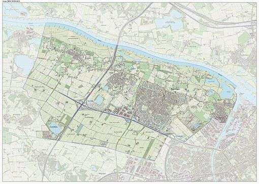
Dutch Topographic map of the municipality of Beuningen, June 2015.
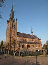
Beuningen, church: de Corneliuskerk
See also
References
- ↑ "Carol van Eert" (in Dutch). Gemeente Beuningen. Retrieved 19 June 2014.
- ↑ "Kerncijfers wijken en buurten" [Key figures for neighbourhoods]. CBS Statline (in Dutch). CBS. 2 July 2013. Retrieved 12 March 2014.
- ↑ "Postcodetool for 6641AE". Actueel Hoogtebestand Nederland (in Dutch). Het Waterschapshuis. Retrieved 19 June 2014.
- ↑ "Bevolkingsontwikkeling; regio per maand" [Population growth; regions per month]. CBS Statline (in Dutch). CBS. 26 June 2014. Retrieved 24 July 2014.
External links
 Media related to Beuningen, Gelderland at Wikimedia Commons
- Official website
 |
Neder-Betuwe Waal |
Overbetuwe Waal |
| |
| Druten | |
Nijmegen | ||
| ||||
| | ||||
| Wijchen |

This article is issued from Wikipedia - version of the 10/30/2016. The text is available under the Creative Commons Attribution/Share Alike but additional terms may apply for the media files.