Overbetuwe
| Overbetuwe | |||
|---|---|---|---|
| Municipality | |||
|
Overbetuwe town hall | |||
| |||
.svg.png) Location in Gelderland | |||
| Coordinates: 51°55′N 5°51′E / 51.917°N 5.850°ECoordinates: 51°55′N 5°51′E / 51.917°N 5.850°E | |||
| Country | Netherlands | ||
| Province | Gelderland | ||
| Established | 1 January 2001[1] | ||
| Government[2] | |||
| • Body | Municipal council | ||
| • Mayor | Toon van Asseldonk | ||
| Area[3] | |||
| • Total | 115.08 km2 (44.43 sq mi) | ||
| • Land | 109.36 km2 (42.22 sq mi) | ||
| • Water | 5.72 km2 (2.21 sq mi) | ||
| Elevation[4] | 10 m (30 ft) | ||
| Population (May 2014)[5] | |||
| • Total | 46,712 | ||
| • Density | 427/km2 (1,110/sq mi) | ||
| Time zone | CET (UTC+1) | ||
| • Summer (DST) | CEST (UTC+2) | ||
| Postcode | 6660–6662, 6665–6668, 6670–6678 | ||
| Area code | 026, 0481, 0488 | ||
| Website |
www | ||
_gemeentehuis.JPG)

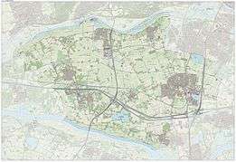
Overbetuwe (![]() pronunciation ) is a municipality in the province of Gelderland in the Netherlands. It was formed on 1 January 2001 as a merger of three former municipalities: Elst, Heteren and Valburg. Overbetuwe is bordered in the north by the river Rhine and in the south by the river Waal. The city hall is located in Elst, the largest town in the municipality. Together with eighteen other municipalities it forms the 'Knooppunt Arnhem-Nijmegen' (English: 'Arnhem-Nijmegen conurbation'), or simply 'KAN', which is a regional collaboration.
pronunciation ) is a municipality in the province of Gelderland in the Netherlands. It was formed on 1 January 2001 as a merger of three former municipalities: Elst, Heteren and Valburg. Overbetuwe is bordered in the north by the river Rhine and in the south by the river Waal. The city hall is located in Elst, the largest town in the municipality. Together with eighteen other municipalities it forms the 'Knooppunt Arnhem-Nijmegen' (English: 'Arnhem-Nijmegen conurbation'), or simply 'KAN', which is a regional collaboration.
Towns
| Town | Inhabitants (2015) |
|---|---|
| Andelst | 1650 |
| Driel | 4205 |
| Elst | 21554 |
| Hemmen | 184 |
| Herveld | 3015 |
| Heteren | 5109 |
| Homoet | 76 |
| Loenen | 47 |
| Oosterhout (partly) | 2337 |
| Randwijk | 1435 |
| Slijk-Ewijk | 479 |
| Valburg | 1780 |
| Zetten | 5002 |
Transportation
Because of its central location between the cities of Nijmegen and Arnhem, many inhabitants of Overbetuwe commute between these cities. Three major highways are situated in the municipality; the A50, A15 and A325. Overbetuwe has two railway stations: Elst and Zetten-Andelst. Besides these two existing railway lines, a controversial freight line called the Betuweroute has been operational from 2007.
Politics
The distribution of council seats after the 2010 elections is shown here.
| Party | Seats |
|---|---|
| CDA | 7 |
| PvdA | 4 |
| Gemeentebelangen Overbetuwe | 5 |
| VVD | 5 |
| D66 | 5 |
| GroenLinks | 2 |
| ChristenUnie | 1 |
Gallery
 Elst, church: de Grote of Sint Maartenskerk
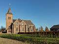 Zetten, church
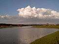 Driel, river: Rhine
 Heteren former townhall
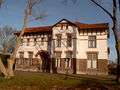 Zetten, het Witte Huis
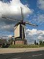 Herveld, windmill: molen de Vink
References
- ↑ "Gemeentelijke indeling op 1 januari 2001" [Municipal divisions on 1 January 2001]. cbs.nl (in Dutch). CBS. Retrieved 15 July 2014.
- ↑ "Samenstelling" [Members] (in Dutch). Gemeente Overbetuwe. Retrieved 15 July 2014.
- ↑ "Kerncijfers wijken en buurten" [Key figures for neighbourhoods]. CBS Statline (in Dutch). CBS. 2 July 2013. Retrieved 12 March 2014.
- ↑ "Postcodetool for 6661EH". Actueel Hoogtebestand Nederland (in Dutch). Het Waterschapshuis. Retrieved 15 July 2014.
- ↑ "Bevolkingsontwikkeling; regio per maand" [Population growth; regions per month]. CBS Statline (in Dutch). CBS. 26 June 2014. Retrieved 24 July 2014.
External links
 Media related to Overbetuwe at Wikimedia Commons
- Official website
 |
Wageningen Nederrijn |
Renkum Nederrijn |
Arnhem | |
| Neder-Betuwe | |
Lingewaard | ||
| ||||
| | ||||
| Waal Beuningen |
Nijmegen |
