Scherpenzeel, Gelderland
| Scherpenzeel | |||
|---|---|---|---|
| Municipality | |||
|
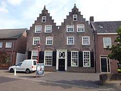
Monumental home in Scherpenzeel | |||
| |||
.svg.png) Location in Gelderland | |||
| Coordinates: 52°5′N 5°28′E / 52.083°N 5.467°ECoordinates: 52°5′N 5°28′E / 52.083°N 5.467°E | |||
| Country | Netherlands | ||
| Province | Gelderland | ||
| Government[1] | |||
| • Body | Municipal council | ||
| • Mayor | Ben Visser (CU) | ||
| Area[2] | |||
| • Total | 13.81 km2 (5.33 sq mi) | ||
| • Land | 13.79 km2 (5.32 sq mi) | ||
| • Water | 0.02 km2 (0.008 sq mi) | ||
| Elevation[3] | 5 m (16 ft) | ||
| Population (May 2014)[4] | |||
| • Total | 9,474 | ||
| • Density | 687/km2 (1,780/sq mi) | ||
| Time zone | CET (UTC+1) | ||
| • Summer (DST) | CEST (UTC+2) | ||
| Postcode | 3925 | ||
| Area code | 033 | ||
| Website |
www | ||


Scherpenzeel (![]() pronunciation ) is a municipality and a town in the Dutch province of Gelderland. As of 2014, it has a population of 9,474, with approximately 6,000 possessing suffrage. The community of Scherpenzeel also contains a part of the hamlet Moorst.
pronunciation ) is a municipality and a town in the Dutch province of Gelderland. As of 2014, it has a population of 9,474, with approximately 6,000 possessing suffrage. The community of Scherpenzeel also contains a part of the hamlet Moorst.
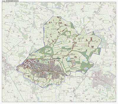
Dutch topographic map of the municipality of Scherpenzeel, June 2015
History
Founding
Centuries ago, what is now the Netherlands was still a collection of small states, ruled by bishops, earls, dukes, and lords. These rulers were constantly at war over territory, causing fortifications and defenses to be built in border areas. This was the case in the Veluwe hills, which lay along the border of what is now Utrecht and Gelderland, where many castles and fortresses were constructed as safe havens. Hence, the name "Scherpenzeel", formerly known as "Scarpenzele", allows us to infer that there was a settlement built around a house ("zele") with sharpened poles ("scarpen"), the prototype of an old castle.
The possession of Scherpenzeel was at various times claimed by either Gelderland or Utrecht, but it has now been a part of Gelderland since 1830.
Scherpenzeel House (town hall)
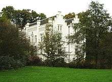
The town's most notable landmark, Scherpenzeel House (Huize Scherpenzeel in Dutch; located at 3 Burgemeester Royaardslaan) began as a 14th-century tower house. In the following centuries, it underwent several modifications. In 1652, it was expanded considerably by Lady Aleyd of Scherpenzeel. In the years 1857–1858, it acquired its present Neogothic form, designed by S.A. van Lunteren, who also designed the surrounding park. At the time it belonged to the Royaard family, who maintained residence there until 1956. In 1975, Scherpenzeel House was declared a national monument and entrusted to the municipality. The building was used as the town hall until 2003.[5]
In 2005, it was let to the Friends of Geldersche Castles Foundation, who keep it open to the public and allow wedding ceremonies to be held there.
References
- ↑ "Taken en bevoegdheden (Portefeuilleverdeling)" (in Dutch). Gemeente Scherpenzeel. Retrieved 17 July 2014.
- ↑ "Kerncijfers wijken en buurten" [Key figures for neighbourhoods]. CBS Statline (in Dutch). CBS. 2 July 2013. Retrieved 12 March 2014.
- ↑ "Postcodetool for 3925CC". Actueel Hoogtebestand Nederland (in Dutch). Het Waterschapshuis. Retrieved 17 July 2014.
- ↑ "Bevolkingsontwikkeling; regio per maand" [Population growth; regions per month]. CBS Statline (in Dutch). CBS. 26 June 2014. Retrieved 24 July 2014.
- ↑ Stenvert, R. et al. (2000), Monumenten in Nederland: Gelderland, p. 287–288. Zwolle: Waanders Uitgevers. ISBN 90-400-9406-3.
External links
 Media related to Scherpenzeel, Gelderland at Wikimedia Commons
- Official website
 |
Barneveld | | ||
| Woudenberg (UT) | |
Renswoude (UT) | ||
| ||||
| | ||||
| Woudenberg (UT), Renswoude (UT) |
