Oude IJsselstreek
| Oude IJsselstreek | |||
|---|---|---|---|
| Municipality | |||
|
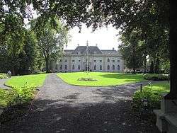
Huis Landfort | |||
| |||
.svg.png) Location in Gelderland | |||
| Coordinates: 51°53′N 6°23′E / 51.883°N 6.383°ECoordinates: 51°53′N 6°23′E / 51.883°N 6.383°E | |||
| Country | Netherlands | ||
| Province | Gelderland | ||
| Established | 1 January 2005[1] | ||
| Government[2] | |||
| • Body | Municipal council | ||
| • Mayor | Otwin van Dijk (PvdA) | ||
| Area[3] | |||
| • Total | 137.94 km2 (53.26 sq mi) | ||
| • Land | 136.40 km2 (52.66 sq mi) | ||
| • Water | 1.54 km2 (0.59 sq mi) | ||
| Elevation[4] | 15 m (49 ft) | ||
| Population (May 2014)[5] | |||
| • Total | 39,582 | ||
| • Density | 290/km2 (800/sq mi) | ||
| Time zone | CET (UTC+1) | ||
| • Summer (DST) | CEST (UTC+2) | ||
| Postcode | 7050–7084 | ||
| Area code | 0315 | ||
| Website |
www | ||

Oude IJsselstreek is a municipality in the eastern Netherlands. It was established on 1 January 2005 through a merger of the former municipalities Gendringen and Wisch.
Geography and population centres
The municipality belongs to the transition area between the rivers in the south, coming from Germany (Rhine and Issel), and the sandy soils of the Eastern Netherlands.
It has 15 population centres. Formerly from Gendringen
- Breedenbroek, Etten, Gendringen, Megchelen, Netterden, Ulft, Varsselder, and Voorst (not to be confused with the municipality of Voorst, also in Gelderland).
Formerly from Wisch
- Bontebrug, Heelweg-Oost and Heelweg-West, Silvolde, Sinderen, Terborg, Varsseveld, and Westendorp.
Terborg is the only population centre with city rights, but the largest one is Ulft with 10,000 inhabitants. The municipality of Oude IJsselstreek is considered to be divided into three units. The centres along the river Oude IJssel (Ulft, Gendringen, Etten on the left border, Silvolde and Terborg on the right) constitute the urban belt, Varsseveld in the east of the municipality is a rural village and the other centres are the external territories. The municipality plans to make Ulft the local centre.
Municipality council
Seats in the municipality Oude IJsselstreek since 2014:
- Lokaal Belang (Local Interests) GVS 8 seats
- Christian Democratic Appeal 5 seats
- Dutch Labour Party 3 seats
- Socialist Party (Netherlands) 3 seats
- Democrats 66 2 seats
- People's Party for Freedom and Democracy 2 seats
Mayor
Hans Alberse was mayor of the newly established municipality Oude IJsselstreek since May 15, 2006. In 2015 he resigned and was replaced by the Commissaris van de Koning with Steven de Vreeze. Since July 2016 the new mayor is Otwin van Dijk.
Topography
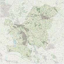
Dutch Topographic map of the municipality of Oude IJsselstreek, June 2015
Culture
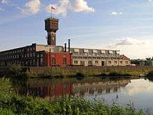
In this essentially rural municipality, there have been some places where iron ore was mined and processed. From the several enterprises the DRU (Diepenbrock en Reigers te Ulft) was the largest, it closed in Ulft in 2003. Since 2009, the former DRU factory is a cultural centre that houses the local library of Ulft, a theater, a regional centre for vocational education and other facilities. Municipal council meetings take place in its conference room.
International affairs
Oude IJsselstreek is a member of the Ring of the European Cities of Iron Works and hosted the annual convention of 2010.
References
- ↑ "Gemeentelijke indeling op 1 januari 2005" [Municipal divisions on 1 January 2005]. cbs.nl (in Dutch). CBS. Retrieved 15 July 2014.
- ↑ "Leden van het college" [Members of the board] (in Dutch). Gemeente Oude IJsselstreek. Retrieved 15 July 2014.
- ↑ "Kerncijfers wijken en buurten" [Key figures for neighbourhoods]. CBS Statline (in Dutch). CBS. 2 July 2013. Retrieved 12 March 2014.
- ↑ "Postcodetool for 7081BN". Actueel Hoogtebestand Nederland (in Dutch). Het Waterschapshuis. Retrieved 15 July 2014.
- ↑ "Bevolkingsontwikkeling; regio per maand" [Population growth; regions per month]. CBS Statline (in Dutch). CBS. 26 June 2014. Retrieved 24 July 2014.
External links
 Media related to Oude IJsselstreek at Wikimedia Commons
- Official website
 |
Bronckhorst | |
Oost Gelre | |
| Doetinchem Montferland |
|
Aalten | ||
| ||||
| | ||||
| Emmerich am Rhein (DE-NW) | Rees (DE-NW), Isselburg (DE-NW) |
