Neerijnen
| Neerijnen | |||
|---|---|---|---|
| Municipality | |||
|
Skyline of Tuil | |||
| |||
.svg.png) Location in Gelderland | |||
| Coordinates: 51°50′N 5°17′E / 51.833°N 5.283°ECoordinates: 51°50′N 5°17′E / 51.833°N 5.283°E | |||
| Country | Netherlands | ||
| Province | Gelderland | ||
| Government[1] | |||
| • Body | Municipal council | ||
| • Mayor | Loes van Ruijven-van Leeuwen (CDA) | ||
| Area[2] | |||
| • Total | 72.90 km2 (28.15 sq mi) | ||
| • Land | 66.00 km2 (25.48 sq mi) | ||
| • Water | 6.90 km2 (2.66 sq mi) | ||
| Elevation[3] | 3 m (10 ft) | ||
| Population (May 2014)[4] | |||
| • Total | 12,006 | ||
| • Density | 182/km2 (470/sq mi) | ||
| Time zone | CET (UTC+1) | ||
| • Summer (DST) | CEST (UTC+2) | ||
| Postcode | 4060–4061, 4063–4064, 4174–4185 | ||
| Area code | 0344, 0418 | ||
| Website |
www | ||
.jpg)

Neerijnen (![]() pronunciation ) is a municipality and a town in the Netherlands. It is about 35 kilometres (22 mi) south of Utrecht and some 15 kilometres (9.3 mi) north of 's-Hertogenbosch.
pronunciation ) is a municipality and a town in the Netherlands. It is about 35 kilometres (22 mi) south of Utrecht and some 15 kilometres (9.3 mi) north of 's-Hertogenbosch.
Population centres
Topography
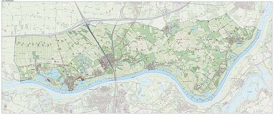
Dutch Topographic map of the municipality of Neerijnen, June 2015
References
- ↑ "Burgemeester mevrouw L.H.M. van Ruijven-van Leeuwen" (in Dutch). Gemeente Neerijnen. Retrieved 10 July 2014.
- ↑ "Kerncijfers wijken en buurten" [Key figures for neighbourhoods]. CBS Statline (in Dutch). CBS. 2 July 2013. Retrieved 12 March 2014.
- ↑ "Postcodetool for 4182CA". Actueel Hoogtebestand Nederland (in Dutch). Het Waterschapshuis. Retrieved 10 July 2014.
- ↑ "Bevolkingsontwikkeling; regio per maand" [Population growth; regions per month]. CBS Statline (in Dutch). CBS. 26 June 2014. Retrieved 24 July 2014.
External links
-
 Media related to Neerijnen at Wikimedia Commons
 - Official website
 |
Geldermalsen, Tiel | | ||
| Lingewaal | |
Waal / West Maas en Waal | ||
| ||||
| | ||||
| Waal Zaltbommel, Maasdriel |

This article is issued from Wikipedia - version of the 1/30/2016. The text is available under the Creative Commons Attribution/Share Alike but additional terms may apply for the media files.