Putten
- for the former island Putten see Voorne-Putten
| Putten | |||
|---|---|---|---|
| Municipality | |||
|
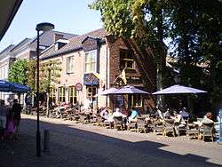
Street in Putten | |||
| |||
.svg.png) Location in Gelderland | |||
| Coordinates: 52°16′N 5°36′E / 52.267°N 5.600°ECoordinates: 52°16′N 5°36′E / 52.267°N 5.600°E | |||
| Country | Netherlands | ||
| Province | Gelderland | ||
| Government[1] | |||
| • Body | Municipal council | ||
| • Mayor | Henk Lambooij (SGP) | ||
| Area[2] | |||
| • Total | 87.41 km2 (33.75 sq mi) | ||
| • Land | 85.12 km2 (32.87 sq mi) | ||
| • Water | 2.29 km2 (0.88 sq mi) | ||
| Elevation[3] | 17 m (56 ft) | ||
| Population (May 2014)[4] | |||
| • Total | 24,148 | ||
| • Density | 284/km2 (740/sq mi) | ||
| Demonym(s) | Puttenaar | ||
| Time zone | CET (UTC+1) | ||
| • Summer (DST) | CEST (UTC+2) | ||
| Postcode | 3880–3882 | ||
| Area code | 0341 | ||
| Website |
www | ||

Putten (![]() pronunciation ) is a municipality and a town in Gelderland province in the middle of the Netherlands. It had a population of
24,148 in 2014. It is located in the coastal area of the old Zuiderzee (Southern Sea). To the east of Putten lies the Veluwe, the biggest national park of the Netherlands. To the north, east and west, Putten is surrounded by farmlands.
pronunciation ) is a municipality and a town in Gelderland province in the middle of the Netherlands. It had a population of
24,148 in 2014. It is located in the coastal area of the old Zuiderzee (Southern Sea). To the east of Putten lies the Veluwe, the biggest national park of the Netherlands. To the north, east and west, Putten is surrounded by farmlands.
Population centres
Bijsteren, Diermen, Gerven, Halvinkhuizen, Hell, Hoef, Huinen, Koudhoorn, Krachtighuizen, Putten, Steenenkamer and Veenhuizerveld.
Topography
History
Until World War II
The oldest official paper in which Putten is mentioned dates back to 855. Small settlements, however, were already in existence during the Roman era. After the founding of the present main church in the 10th century, the community became the center of several smaller settlements. Parts of Nijkerk and Voorthuizen also became part of the Putten area, until in 1530 Nijkerk, and later also Voorthuizen, became independent communities.
Until 1356, when a dyke was built, the coastline changed frequently, overflowing agricultural land in the west of Putten. The water was still a threat however, and the dyke broke through several times. The last major flood was in 1916, when large parts of Putten were flooded. After the Afsluitdijk was built in the north of the Netherlands, the Zuiderzee became a lake (1927-1933) and no longer posed a threat.
Agriculture has always been a major source of income in Putten. The manufacturing of paper was also important in the 17th to 19th centuries. From the end of the 19th century tourism emerged, helped by the arrival of the railway in 1863. This made it easier for people from other towns to holiday in the boarding houses that Putten had built. Among those people from elsewhere were also patients who suffered from tuberculosis and similar diseases. They benefited from the sunlight and clean air and recuperated in several sanatoria.
Putten has suffered considerably from military violence. During the 15th, 16th and 17th century Putten was burned down on at least five occasions.
World War II
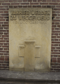
One of the biggest Nazi raids to be held in the Netherlands during World War II took place in Putten. On 1 October and 2 October 1944, 661 men and boys, the majority of the male population, were deported from the town and 602 of them were sent to work in concentration camps such as Neuengamme and Birkenau. Five hundred and forty of them died in concentration camps and only 49 survived to return after the war. Following the war, two of the responsible German officers were tried and convicted for this action. The raids were a retaliatory measure for an attack by the local resistance, that killed one Wehrmacht officer near Nijkerk. The first and second of October are commemorated every year. A war memorial at Putten Church and a memorial garden (Vrouwtje van Putten Herdenkingshof) commemorate the event and the loss of life.
| Total number of men deported | 661 |
| Released in Amersfoort | 59 |
| Deported to Neuengamme | 602 |
| Jumped out of the train on the way to Neuengamme | 13 |
| Arrived in Neuengamme | 589 |
| Returned to Putten after liberation | 49 |
| Died in German concentration camps | 540 |
| Killed during the raid | 7 |
| Died shortly after the return | 5 |
| Total number of deaths | 552 |
Economy
Today agriculture is still important in Putten, but the service sector now predominates. There are considerable numbers of shops, and tourism is important. Tourists are attracted by the varied landscape and the beach at the Ring Lake (Strand Nulde). Every Wednesday there is a produce and food market that is the biggest in the North-West Veluwe area.
Transport
Putten lies next to the A28 highway that connects Utrecht with the north. The town has a train station on the line between Utrecht and Zwolle. There are also bus connections.
References
- ↑ "Burgemeester H.A. Lambooij" [Mayor H.A. Lambooij] (in Dutch). Gemeente Putten. Retrieved 17 June 2014.
- ↑ "Kerncijfers wijken en buurten" [Key figures for neighbourhoods]. CBS Statline (in Dutch). CBS. 2 July 2013. Retrieved 12 March 2014.
- ↑ "Postcodetool for 3881BZ". Actueel Hoogtebestand Nederland (in Dutch). Het Waterschapshuis. Retrieved 17 June 2014.
- ↑ "Bevolkingsontwikkeling; regio per maand" [Population growth; regions per month]. CBS Statline (in Dutch). CBS. 26 June 2014. Retrieved 24 July 2014.
External links
 Media related to Putten, Gelderland at Wikimedia Commons
- Official website
- Website Stichting Oktober 44 (war crime)
 |
Zeewolde (FL) / Nuldernauw | |
Ermelo | |
| |
||||
| ||||
| | ||||
| Nijkerk | |
Barneveld |
