East Gull Lake, Minnesota
| East Gull Lake, Minnesota | |
|---|---|
| City | |
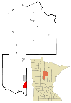 Location of East Gull Lake within Cass County, Minnesota | |
| Coordinates: 46°23′49″N 94°21′49″W / 46.39694°N 94.36361°W | |
| Country | United States |
| State | Minnesota |
| County | Cass |
| Area[1] | |
| • Total | 14.82 sq mi (38.38 km2) |
| • Land | 7.86 sq mi (20.36 km2) |
| • Water | 6.96 sq mi (18.03 km2) |
| Elevation | 1,253 ft (382 m) |
| Population (2010)[2] | |
| • Total | 1,004 |
| • Estimate (2012[3]) | 995 |
| • Density | 127.7/sq mi (49.3/km2) |
| Time zone | Central (CST) (UTC-6) |
| • Summer (DST) | CDT (UTC-5) |
| FIPS code | 27-17630[4] |
| GNIS feature ID | 0643080[5] |
East Gull Lake is a city in Cass County, Minnesota, United States. The population was 1,004 at the 2010 census.[6] The nearest semi-urban area is that of Brainerd and Baxter. It is part of the Brainerd Micropolitan Statistical Area. East Gull Lake is situated in the Brainerd Lakes Area of Central Minnesota, and takes its name from the largest lake within its borders, Gull Lake.[7]
The local airport is East Gull Lake Airport (FAA code 9Y2), a small 2-runway airport.
History
East Gull Lake was incorporated in 1947.[8]
Geography
According to the United States Census Bureau, the city has a total area of 14.82 square miles (38.38 km2), of which, 7.86 square miles (20.36 km2) is land and 6.96 square miles (18.03 km2) is water.[1] County Roads 18, 70, and 77 are the main routes in the community.
Tourism and recreation
Mainly because of these lakes, much of the activity in the town is tourism, recreation, and vacationing, especially by residents of Minnesota and Iowa who maintain summer homes in the area. Houses immediately on the shores of Gull Lake are the most prized and the most expensive, and have attracted residents such as Kristi Yamaguchi and her husband Bret Hedican . There are several high-end resorts in the city, including Cragun's Resort, Madden's Resort, Kavanaugh's Resort, and Gull Lake Resort. Several of the resorts include large golf courses. The population increased extremely in the past three years and now (10/04/2008) is more than 2,000 all year.
Demographics
| Historical population | |||
|---|---|---|---|
| Census | Pop. | %± | |
| 1940 | 125 | — | |
| 1950 | 238 | 90.4% | |
| 1960 | 311 | 30.7% | |
| 1970 | 440 | 41.5% | |
| 1980 | 586 | 33.2% | |
| 1990 | 687 | 17.2% | |
| 2000 | 978 | 42.4% | |
| 2010 | 1,004 | 2.7% | |
| Est. 2015 | 1,011 | [9] | 0.7% |
| U.S. Decennial Census | |||
2010 census
As of the census[2] of 2010, there were 1,004 people, 407 households, and 310 families residing in the city. The population density was 127.7 inhabitants per square mile (49.3/km2). There were 792 housing units at an average density of 100.8 per square mile (38.9/km2). The racial makeup of the city was 98.6% White, 0.2% Native American, 0.5% Asian, 0.3% from other races, and 0.4% from two or more races. Hispanic or Latino of any race were 1.8% of the population.
There were 407 households of which 23.8% had children under the age of 18 living with them, 69.3% were married couples living together, 3.9% had a female householder with no husband present, 2.9% had a male householder with no wife present, and 23.8% were non-families. 18.9% of all households were made up of individuals and 8.4% had someone living alone who was 65 years of age or older. The average household size was 2.46 and the average family size was 2.78.
The median age in the city was 47.7 years. 21.2% of residents were under the age of 18; 4.4% were between the ages of 18 and 24; 21% were from 25 to 44; 32.7% were from 45 to 64; and 21% were 65 years of age or older. The gender makeup of the city was 53.3% male and 46.7% female.
2000 census
As of the census[4] of 2000, there were 978 people, 370 households, and 294 families residing in the city. The population density was 123.6 people per square meter (47.7/km²). There were 709 housing units at an average density of 89.6 per square mile (34.6/km²). The racial makeup of the city was 98.16% White, 0.31% African American, 0.10% Native American, 0.72% Asian, 0.20% from other races, and 0.51% from two or more races. Hispanic or Latino of any race were 1.43% of the population.
There were 370 households out of which 30.3% had children under the age of 18 living with them, 73.2% were married couples living together, 3.0% had a female householder with no husband present, and 20.3% were non-families. 17.6% of all households were made up of individuals and 6.5% had someone living alone who was 65 years of age or older. The average household size was 2.64 and the average family size was 2.97.
In the city the population was spread out with 26.0% under the age of 18, 6.5% from 18 to 24, 26.5% from 25 to 44, 28.1% from 45 to 64, and 12.9% who were 65 years of age or older. The median age was 39 years. For every 100 females there were 107.2 males. For every 100 females age 18 and over, there were 108.6 males.
The median income for a household in the city was $55,750, and the median income for a family was $62,813. Males had a median income of $40,809 versus $28,750 for females. The per capita income for the city was $27,329. About 6.6% of families and 8.7% of the population were below the poverty line, including 12.0% of those under age 18 and 8.3% of those age 65 or over.
News
The Northern Herald
https://web.archive.org/web/20100414232528/http://northernherald.finalhost.net:80/v13n2.pdf
References
- 1 2 "US Gazetteer files 2010". United States Census Bureau. Archived from the original on 2012-01-24. Retrieved 2012-11-13.
- 1 2 "American FactFinder". United States Census Bureau. Retrieved 2012-11-13.
- ↑ "Population Estimates". United States Census Bureau. Archived from the original on 2013-06-17. Retrieved 2013-05-28.
- 1 2 "American FactFinder". United States Census Bureau. Archived from the original on 2013-09-11. Retrieved 2008-01-31.
- ↑ "US Board on Geographic Names". United States Geological Survey. 2007-10-25. Retrieved 2008-01-31.
- ↑ "2010 Census Redistricting Data (Public Law 94-171) Summary File". American FactFinder. U.S. Census Bureau, 2010 Census. Archived from the original on 21 July 2011. Retrieved 23 April 2011.
- ↑ Upham, Warren (1920). Minnesota Geographic Names: Their Origin and Historic Significance. Minnesota Historical Society. p. 89.
- ↑ Upham, Warren (2001). Minnesota Place Names: A Geographical Encyclopedia. Minnesota Historical Society Press. p. 94. ISBN 978-0-87351-396-8.
- ↑ "Annual Estimates of the Resident Population for Incorporated Places: April 1, 2010 to July 1, 2015". Retrieved July 2, 2016.
External links
Municipalities and communities of Cass County, Minnesota, United States | ||
|---|---|---|
| Cities |  | |
| Townships |
| |
| Unorganized territories | ||
| CDP | ||
| Unincorporated communities | ||
| Indian reservation | ||
| Ghost town | ||
| Footnotes | ‡This populated place also has portions in an adjacent county or counties | |
Cities in the Brainerd Lakes area, Minnesota | |||||||
|---|---|---|---|---|---|---|---|
| Core City |  | ||||||
| Surrounding communities |
| ||||||
| Counties | |||||||
† indicates a county seat. ‡ indicates that it is partially in the micropolitan area. § indicates a CDP. | |||||||
Coordinates: 46°24′29″N 94°21′21″W / 46.40806°N 94.35583°W