Trommald, Minnesota
| Trommald, Minnesota | |
|---|---|
| City | |
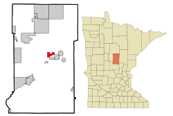 Location of Trommald within Crow Wing County, Minnesota | |
| Coordinates: 46°30′23″N 94°1′3″W / 46.50639°N 94.01750°W | |
| Country | United States |
| State | Minnesota |
| County | Crow Wing |
| Area[1] | |
| • Total | 3.93 sq mi (10.18 km2) |
| • Land | 3.65 sq mi (9.45 km2) |
| • Water | 0.28 sq mi (0.73 km2) |
| Elevation | 1,220 ft (372 m) |
| Population (2010)[2] | |
| • Total | 98 |
| • Estimate (2012[3]) | 100 |
| • Density | 26.8/sq mi (10.3/km2) |
| Time zone | Central (CST) (UTC-6) |
| • Summer (DST) | CDT (UTC-5) |
| ZIP code | 56441 |
| Area code(s) | 218 |
| FIPS code | 27-65506[4] |
| GNIS feature ID | 0653329[5] |
Trommald is a city in Crow Wing County, Minnesota, United States. The population was 98 at the 2010 census.[6] It is part of the Brainerd Micropolitan Statistical Area.
Trommald was founded as a mining town on the western end of the Cuyuna iron range, just north of Ironton.
History
Trommald was named for A. G. Trommald, county registrar of deeds from 1904 to 1930. Trommald was incorporated in 1917.[7]
Geography
According to the United States Census Bureau, the city has a total area of 3.93 square miles (10.18 km2), of which 3.65 square miles (9.45 km2) is land and 0.28 square miles (0.73 km2) is water.[1] County Roads 30 and 34, and Iverson Road are the main routes in the community.
Demographics
| Historical population | |||
|---|---|---|---|
| Census | Pop. | %± | |
| 1920 | 301 | — | |
| 1930 | 242 | −19.6% | |
| 1940 | 166 | −31.4% | |
| 1950 | 117 | −29.5% | |
| 1960 | 101 | −13.7% | |
| 1970 | 82 | −18.8% | |
| 1980 | 84 | 2.4% | |
| 1990 | 80 | −4.8% | |
| 2000 | 125 | 56.3% | |
| 2010 | 98 | −21.6% | |
| Est. 2015 | 101 | [8] | 3.1% |
| U.S. Decennial Census | |||
2010 census
As of the census[2] of 2010, there were 98 people, 46 households, and 26 families residing in the city. The population density was 26.8 inhabitants per square mile (10.3/km2). There were 55 housing units at an average density of 15.1 per square mile (5.8/km2). The racial makeup of the city was 96.9% White, 2.0% Native American, and 1.0% from two or more races. Hispanic or Latino of any race were 1.0% of the population.
There were 46 households of which 19.6% had children under the age of 18 living with them, 43.5% were married couples living together, 4.3% had a female householder with no husband present, 8.7% had a male householder with no wife present, and 43.5% were non-families. 30.4% of all households were made up of individuals and 10.8% had someone living alone who was 65 years of age or older. The average household size was 2.13 and the average family size was 2.65.
The median age in the city was 45 years. 19.4% of residents were under the age of 18; 7.2% were between the ages of 18 and 24; 23.5% were from 25 to 44; 40.8% were from 45 to 64; and 9.2% were 65 years of age or older. The gender makeup of the city was 57.1% male and 42.9% female.
2000 census
As of the census[4] of 2000, there were 125 people, 47 households, and 28 families residing in the village. The population density was 33.8 people per square mile (13.0/km²). There were 52 housing units at an average density of 14.0 per square mile (5.4/km²). The racial makeup of the village was 97.60% White, 0.80% Native American, and 1.60% from two or more races. 21.7% were of Norwegian, 12.3% Irish, 10.4% Swedish, 9.4% German, 7.5% French Canadian, 6.6% Italian, 6.6% Polish and 5.7% English ancestry according to Census 2000.
There were 47 households out of which 38.3% had children under the age of 18 living with them, 53.2% were married couples living together, 2.1% had a female householder with no husband present, and 40.4% were non-families. 31.9% of all households were made up of individuals and 6.4% had someone living alone who was 65 years of age or older. The average household size was 2.66 and the average family size was 3.50.
In the village the population was spread out with 31.2% under the age of 18, 8.0% from 18 to 24, 31.2% from 25 to 44, 21.6% from 45 to 64, and 8.0% who were 65 years of age or older. The median age was 34 years. For every 100 females there were 127.3 males. For every 100 females age 18 and over, there were 126.3 males.
The median income for a household in the village was $21,500, and the median income for a family was $42,083. Males had a median income of $43,333 versus $18,750 for females. The per capita income for the city was $14,714. There were 9.7% of families and 16.0% of the population living below the poverty line, including 8.5% of under eighteens and 18.2% of those over 64.
References
- 1 2 "US Gazetteer files 2010". United States Census Bureau. Retrieved 2012-11-13.
- 1 2 "American FactFinder". United States Census Bureau. Retrieved 2012-11-13.
- ↑ "Population Estimates". United States Census Bureau. Retrieved 2013-05-28.
- 1 2 "American FactFinder". United States Census Bureau. Retrieved 2008-01-31.
- ↑ "US Board on Geographic Names". United States Geological Survey. 2007-10-25. Retrieved 2008-01-31.
- ↑ "2010 Census Redistricting Data (Public Law 94-171) Summary File". American FactFinder. U.S. Census Bureau, 2010 Census. Retrieved 23 April 2011.
- ↑ Upham, Warren (2001). Minnesota Place Names: A Geographical Encyclopedia. Minnesota Historical Society Press. p. 162. ISBN 978-0-87351-396-8.
- ↑ "Annual Estimates of the Resident Population for Incorporated Places: April 1, 2010 to July 1, 2015". Retrieved July 2, 2016.
Municipalities and communities of Crow Wing County, Minnesota, United States | ||
|---|---|---|
| Cities | 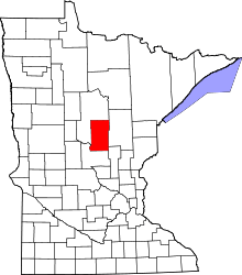 | |
| Townships | ||
| Unorganized territories | ||
| CDP | ||
| Unincorporated communities | ||
| Indian reservation | ||
| Ghost towns | ||
| Footnotes | ‡This populated place also has portions in an adjacent county or counties | |
Cities in the Brainerd Lakes area, Minnesota | |||||||
|---|---|---|---|---|---|---|---|
| Core City | 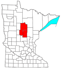 | ||||||
| Surrounding communities |
| ||||||
| Counties | |||||||
† indicates a county seat. ‡ indicates that it is partially in the micropolitan area. § indicates a CDP. | |||||||
Coordinates: 46°30′19″N 94°01′06″W / 46.50528°N 94.01833°W