Remer, Minnesota
| Remer, Minnesota | |
|---|---|
| City | |
 Location of Remer within Cass County, Minnesota | |
| Coordinates: 47°3′21″N 93°54′50″W / 47.05583°N 93.91389°W | |
| Country | United States |
| State | Minnesota |
| County | Cass |
| Area[1] | |
| • Total | 1.38 sq mi (3.57 km2) |
| • Land | 1.38 sq mi (3.57 km2) |
| • Water | 0 sq mi (0 km2) |
| Elevation | 1,342 ft (409 m) |
| Population (2010)[2] | |
| • Total | 370 |
| • Estimate (2012[3]) | 363 |
| • Density | 268.1/sq mi (103.5/km2) |
| Time zone | Central (CST) (UTC-6) |
| • Summer (DST) | CDT (UTC-5) |
| ZIP code | 56672 |
| Area code(s) | 218 |
| FIPS code | 27-53782[4] |
| GNIS feature ID | 0658015[5] |
Remer is a city in Cass County, Minnesota, United States. The population was 370 at the 2010 census.[6] It is part of the Brainerd Micropolitan Statistical Area.
Minnesota State Highways 6 and 200 are two of the main arterial routes in the community.
History
A post office called Remer has been in operation since 1904.[7] The city was named for its first postmaster, William P. Remer.[8]
Late in World War Two, a logging camp manned by prisoners of war was located at the site of an old CCC camp near Remer.[9]
Geography
According to the United States Census Bureau, the city has a total area of 1.38 square miles (3.57 km2), all of it land.[1] The elevation is 1,342 ft (409 m) above sea level.
Demographics
| Historical population | |||
|---|---|---|---|
| Census | Pop. | %± | |
| 1920 | 290 | — | |
| 1930 | 263 | −9.3% | |
| 1940 | 407 | 54.8% | |
| 1950 | 412 | 1.2% | |
| 1960 | 492 | 19.4% | |
| 1970 | 403 | −18.1% | |
| 1980 | 396 | −1.7% | |
| 1990 | 342 | −13.6% | |
| 2000 | 372 | 8.8% | |
| 2010 | 370 | −0.5% | |
| Est. 2015 | 362 | [10] | −2.2% |
Remer is also the location of the Thunder Lake Lodge where Al Capone would stay on his vacations to Minnesota. The room he stayed in was named McCleary Cabin, which was originally built in 1912.[12] In 2009, a motion-activated camera captured a picture of what some consider to be Bigfoot in an area near Remer, MN. Since then, Remer has been known as the Bigfoot capital of the world.[13]
2010 census
As of the census[2] of 2010, there were 370 people, 175 households, and 95 families residing in the city. The population density was 268.1 inhabitants per square mile (103.5/km2). There were 208 housing units at an average density of 150.7 per square mile (58.2/km2). The racial makeup of the city was 96.8% White, 1.9% Native American, and 1.4% from two or more races. Hispanic or Latino of any race were 1.6% of the population.
There were 175 households of which 25.7% had children under the age of 18 living with them, 34.3% were married couples living together, 17.1% had a female householder with no husband present, 2.9% had a male householder with no wife present, and 45.7% were non-families. 38.9% of all households were made up of individuals and 18.3% had someone living alone who was 65 years of age or older. The average household size was 2.11 and the average family size was 2.85.
The median age in the city was 43.5 years. 22.2% of residents were under the age of 18; 8.3% were between the ages of 18 and 24; 21.1% were from 25 to 44; 26.5% were from 45 to 64; and 21.9% were 65 years of age or older. The gender makeup of the city was 46.8% male and 53.2% female.
2000 census
As of the census[4] of 2000, there were 372 people, 178 households, and 95 families residing in the city. The population density was 327.8 people per square mile (127.1/km²). There were 198 housing units at an average density of 174.5 per square mile (67.7/km²). The racial makeup of the city was 95.97% White, 0.27% African American, 2.69% Native American, and 1.08% from two or more races.
There were 178 households out of which 29.8% had children under the age of 18 living with them, 39.3% were married couples living together, 10.1% had a female householder with no husband present, and 46.6% were non-families. 41.0% of all households were made up of individuals and 28.1% had someone living alone who was 65 years of age or older. The average household size was 2.09 and the average family size was 2.87.
In the city the population was spread out with 25.5% under the age of 18, 5.9% from 18 to 24, 19.4% from 25 to 44, 26.3% from 45 to 64, and 22.8% who were 65 years of age or older. The median age was 44 years. For every 100 females there were 83.3 males. For every 100 females age 18 and over, there were 84.7 males.
The median income for a household in the city was $19,583, and the median income for a family was $27,500. Males had a median income of $28,000 versus $20,536 for females. The per capita income for the city was $11,674. About 25.9% of families and 34.5% of the population were below the poverty line, including 52.9% of those under age 18 and 22.2% of those age 65 or over.
Records
Remer currently lays claim to the World's Largest Eagle statue.[14]
References
- 1 2 "US Gazetteer files 2010". United States Census Bureau. Retrieved 2012-11-13.
- 1 2 "American FactFinder". United States Census Bureau. Retrieved 2012-11-13.
- ↑ "Population Estimates". United States Census Bureau. Retrieved 2013-05-28.
- 1 2 "American FactFinder". United States Census Bureau. Retrieved 2008-01-31.
- ↑ "US Board on Geographic Names". United States Geological Survey. 2007-10-25. Retrieved 2008-01-31.
- ↑ "2010 Census Redistricting Data (Public Law 94-171) Summary File". American FactFinder. U.S. Census Bureau, 2010 Census. Retrieved 23 April 2011.
- ↑ "Cass County". Jim Forte Postal History. Retrieved 12 April 2015.
- ↑ Upham, Warren (1920). Minnesota Geographic Names: Their Origin and Historic Significance. Minnesota Historical Society. p. 92.
- ↑ Pluth, Edward J. (Winter 1975). "Prisoner of War Employment in Minnesota During World War II" (PDF). Minnesota History. Minnesota Historical Society. p. 295. Retrieved June 20, 2014.
- ↑ "Annual Estimates of the Resident Population for Incorporated Places: April 1, 2010 to July 1, 2015". Retrieved July 2, 2016.
- ↑ "Census of Population and Housing". Census.gov. Retrieved June 4, 2015.
- ↑
- ↑
- ↑ "What's Large Where in the US". World's Largest Things. Retrieved 3 July 2011.
External links
Municipalities and communities of Cass County, Minnesota, United States | ||
|---|---|---|
| Cities | 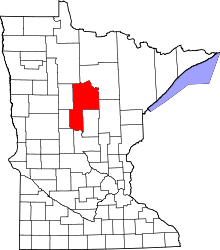 | |
| Townships |
| |
| Unorganized territories | ||
| CDP | ||
| Unincorporated communities | ||
| Indian reservation | ||
| Ghost town | ||
| Footnotes | ‡This populated place also has portions in an adjacent county or counties | |
Cities in the Brainerd Lakes area, Minnesota | |||||||
|---|---|---|---|---|---|---|---|
| Core City |  | ||||||
| Surrounding communities |
| ||||||
| Counties | |||||||
† indicates a county seat. ‡ indicates that it is partially in the micropolitan area. § indicates a CDP. | |||||||
Coordinates: 47°03′22″N 93°54′58″W / 47.05611°N 93.91611°W