Merrifield, Minnesota
| Merrifield, Minnesota | |
|---|---|
| Census-designated place (CDP) and Unincorporated community | |
 Merrifield, Minnesota Location of the community of Merrifield | |
| Coordinates: 46°27′54″N 94°10′22″W / 46.46500°N 94.17278°WCoordinates: 46°27′54″N 94°10′22″W / 46.46500°N 94.17278°W | |
| Country | United States |
| State | Minnesota |
| County | Crow Wing |
| Township | Lake Edward Township |
| Area[1] | |
| • Total | 0.543 sq mi (1.41 km2) |
| • Land | 0.543 sq mi (1.41 km2) |
| • Water | 0 sq mi (0 km2) |
| Elevation | 1,220 ft (370 m) |
| Population (2010)[2] | |
| • Total | 140 |
| • Density | 260/sq mi (100/km2) |
| Time zone | Central (CST) (UTC-6) |
| • Summer (DST) | CDT (UTC-5) |
| ZIP code | 56465 |
| Area code(s) | 218 |
| GNIS feature ID | 647778[3] |
Merrifield is an unincorporated community and census-designated place (CDP) in Lake Edward Township, Crow Wing County, Minnesota, United States, near Brainerd. It is along Crow Wing County Road 3 near County Road 127. Its population was 140 as of the 2010 census.[2]
History
A post office called Merrifield has been in operation since 1899.[4] The community was named for the original owner of the town site.[5]
References
- ↑ "US Gazetteer files: 2010, 2000, and 1990". United States Census Bureau. 2011-02-12. Retrieved 2011-04-23.
- 1 2 "American FactFinder". United States Census Bureau. Retrieved 2011-05-14.
- ↑ "Merrifield, Minnesota". Geographic Names Information System. United States Geological Survey.
- ↑ "Crow Wing County". Jim Forte Postal History. Retrieved 10 May 2015.
- ↑ Warren Upham (1920). Minnesota Geographic Names: Their Origin and Historic Significance. Minnesota Historical Society. p. 158.
Municipalities and communities of Crow Wing County, Minnesota, United States | ||
|---|---|---|
| Cities | 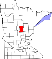 | |
| Townships | ||
| Unorganized territories | ||
| CDP | ||
| Unincorporated communities | ||
| Indian reservation | ||
| Ghost towns | ||
| Footnotes | ‡This populated place also has portions in an adjacent county or counties | |
Cities in the Brainerd Lakes area, Minnesota | |||||||
|---|---|---|---|---|---|---|---|
| Core City | 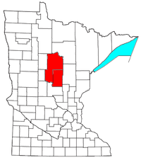 | ||||||
| Surrounding communities |
| ||||||
| Counties | |||||||
† indicates a county seat. ‡ indicates that it is partially in the micropolitan area. § indicates a CDP. | |||||||
This article is issued from Wikipedia - version of the 10/25/2016. The text is available under the Creative Commons Attribution/Share Alike but additional terms may apply for the media files.