Ibirá
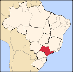
Ibirá is a municipality in the state of São Paulo, Brazil. The population is 11,861 (2015 est.) in an area of 190 km².[1] Ibirá is known as a tourist resort, due to the thermal waters.
Neighboring municipalities
Geography
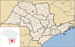
The municipality of Ibirá is situated in the northern part of São Paulo state. Its main river is the Rio do Cubatão, a tributary of the Tietê River.
Demographics
Population history
| Year | Population |
|---|
| 2001 | 9,447 |
| 2004 | 9,824 |
| 2010 | 10,896 |
| 2015 | 11,861 |
Transportation
- SP-310 Highway Washington Luís
- SP-379 Rodovia Roberto Mario Perosa
Notable people
External links
References
|
|---|
|
|
|
|
|
| |
|---|
| Capital | |
|---|
| 1,000,000+ | |
|---|
| 500,000+ | |
|---|
| 200,000+ | |
|---|
| 100,000+ | |
|---|
|
|
|
| |
|---|
| São José do Rio Preto |
|---|
| Auriflama | |
|---|
| Catanduva | |
|---|
| Fernandópolis | |
|---|
| Jales | |
|---|
| Nhandeara | |
|---|
| Novo Horizonte | |
|---|
| São José do Rio Preto | |
|---|
| Votuporanga | |
|---|
|
|
|
|
|
|---|
|
|
|
| Araçatuba |
|---|
| Andradina | |
|---|
| Araçatuba | |
|---|
| Birigui | |
|---|
|
| |
|
|
|
|
|
| Bauru |
|---|
| Avaré | |
|---|
| Bauru | |
|---|
| Botucatu | |
|---|
| Jaú | |
|---|
| Lins | |
|---|
|
|
|
| Campinas |
|---|
| Amparo | |
|---|
| Campinas | |
|---|
| Mogi Mirim | |
|---|
| Pirassununga | |
|---|
| São João da Boa Vista | |
|---|
|
|
|
| Itapetininga |
|---|
| Capão Bonito | |
|---|
| Itapetininga | |
|---|
| Itapeva | |
|---|
| Tatuí | |
|---|
|
|
|
|
|
| Macro Metropolitana Paulista |
|---|
| Bragança Paulista | |
|---|
| Jundiaí | |
|---|
| Piedade | |
|---|
| Sorocaba | |
|---|
|
|
|
|
|
| Metropolitana de São Paulo |
|---|
| Franco da Rocha | |
|---|
| Guarulhos | |
|---|
| Itapecerica da Serra | |
|---|
| Mogi das Cruzes | |
|---|
| Osasco | |
|---|
| Santos | |
|---|
| São Paulo | |
|---|
|
|
|
| Piracicaba |
|---|
| Limeira | |
|---|
| Piracicaba | |
|---|
| Rio Claro | |
|---|
|
|
|
| Presidente Prudente |
|---|
| Adamantina | |
|---|
| Dracena | |
|---|
| Presidente Prudente | |
|---|
|
|
|
| Ribeirão Preto |
|---|
| Barretos | |
|---|
| Batatais | |
|---|
| Franca | |
|---|
| Ituverava | |
|---|
| Jaboticabal | |
|---|
| Ribeirão Preto | |
|---|
| São Joaquim da Barra | |
|---|
|
|
|
| São José do Rio Preto |
|---|
| Auriflama | |
|---|
| Catanduva | |
|---|
| Fernandópolis | |
|---|
| Jales | |
|---|
| Nhandeara | |
|---|
| Novo Horizonte | |
|---|
| São José do Rio Preto | |
|---|
| Votuporanga | |
|---|
|
|
|
| Vale do Paraíba Paulista |
|---|
| Bananal | |
|---|
| Campos do Jordão | |
|---|
| Caraguatatuba | |
|---|
| Guaratinguetá | |
|---|
| Paraibuna/Paraitinga | |
|---|
| São José dos Campos | |
|---|
|
|