List of the major 100-kilometer summits of the United States
The following sortable table lists the 107 mountain peaks of the United States with at least 100 kilometers (62.14 miles) of topographic isolation and at least 500 meters (1640 feet) of topographic prominence.[1]
The summit of a mountain or hill may be measured in three principal ways:
- The topographic elevation of a summit measures the height of the summit above a geodetic sea level.[2][3]
- The topographic prominence of a summit is a measure of how high the summit rises above its surroundings.[4][3]
- The topographic isolation (or radius of dominance) of a summit measures how far the summit lies from its nearest point of equal elevation.[5]
In the United States, only Denali exceeds 4000 kilometers (2485 miles) of topographic isolation. Three major summits exceed 2000 kilometers (1243 miles), seven exceed 1000 kilometers (621.4 miles), 12 exceed 500 kilometers (310.7 miles), 44 exceed 200 kilometers (124.3 miles), the following 107 major summits exceed 100 kilometers (62.14 miles), and 205 exceed 50 kilometers (31.07 miles) of topographic isolation.
Major 100-kilometer summits
Of these 107 major 100-kilometer summits of the United States, 38 are located in Alaska, nine in California, eight in Montana, seven in Arizona, six in Nevada, four in Hawaiʻi, four in Wyoming, four in Utah, three in Washington, three in Colorado, three in New Mexico, three in Idaho, three in Oregon, two in North Carolina, two in Maine, two in New York, two in Texas, and one each in New Hampshire, Arkansas, West Virginia, South Dakota, and Tennessee. Two of these summits lie on the international Alaska-British Columbia border and one lies on the Tennessee-North Carolina state border.
Gallery
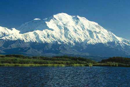
- 1. Denali in Alaska is the highest summit of the United States and all of North America.
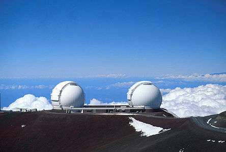 2. Mauna Kea on the Island of Hawaiʻi is the tallest mountain on Earth as measured from base to summit.
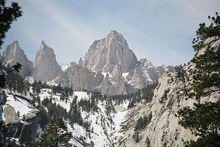 3. Mount Whitney highest summit of the Sierra Nevada and California.
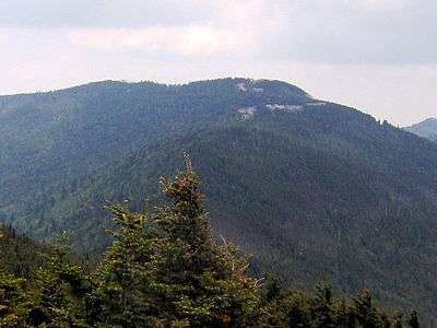 4. Mount Mitchell is the highest summit of North Carolina and the Appalachian Mountains.
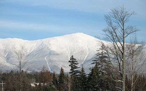 5. Mount Washington is the highest summit of the White Mountains and New Hampshire.
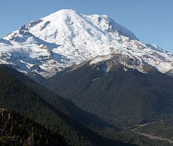 6. Mount Rainier is the highest summit of Washington and the Cascade Range.
 7. Mount Elbert is the highest summit of Colorado and the Rocky Mountains.
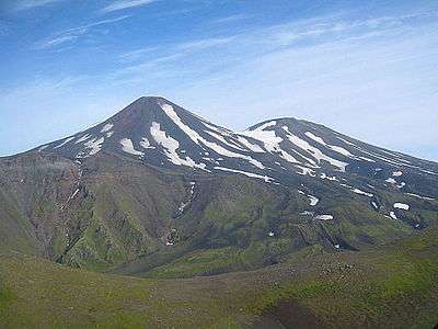
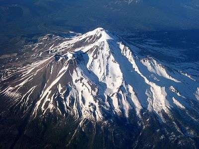 12. Mount Shasta in California is the highest summit of the southern Cascade Range.
 13. Gannett Peak is the highest summit of the Wind River Range and Wyoming.
 16. Humphreys Peak is the highest summit of the San Francisco Peaks and Arizona.
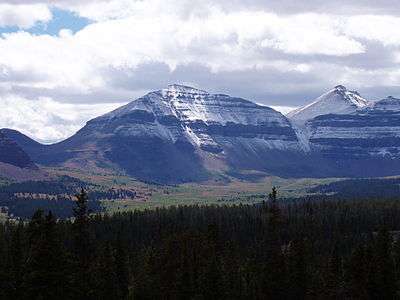 24. Kings Peak is the highest summit of the Uinta Range and Utah.
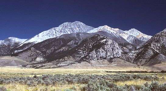 31. Borah Peak is the highest summit of the Lost River Range and Idaho.
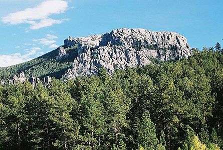 33. Black Elk Peak is the highest summit of the Black Hills and South Dakota.
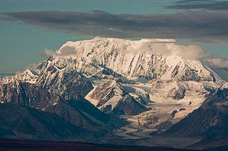 40. Mount Hayes is the highest summit of the eastern Alaska Range.
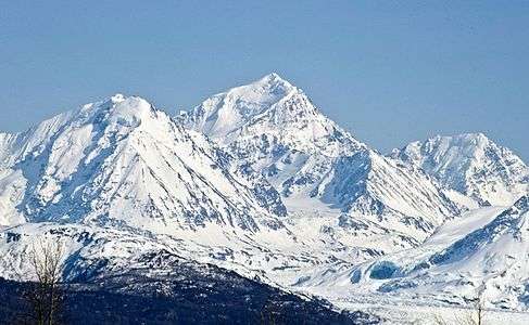 41. Mount Marcus Baker is the highest summit of the Chugach Mountains of Alaska.
 44. Mount Fairweather lies on the Alaska-British Columbia international border.
 64. Granite Peak is the highest summit of the Beartooth Range and Montana.
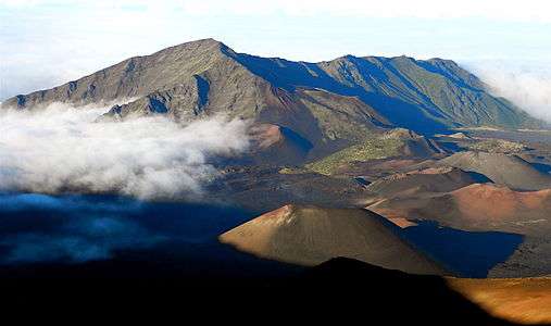 82. Haleakalā is the highest summit of the Island of Maui.
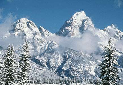 95. Grand Teton in Wyoming is the highest summit of the Teton Range.
See also
- List of mountain peaks of North America
- List of mountain peaks of Greenland
- List of mountain peaks of Canada
- List of mountain peaks of the Rocky Mountains
- List of mountain peaks of the United States
- List of the highest major summits of the United States
- List of the most prominent summits of the United States
- List of the most isolated major summits of the United States
- List of the major 100-kilometer summits of the United States
- List of mountain peaks of Alaska
- List of mountain peaks of California
- List of mountain peaks of Colorado
- List of mountain peaks of Hawaiʻi
- List of mountain peaks of México
- List of mountain peaks of Central America
- List of mountain peaks of the Caribbean
- United States of America
- Geography of the United States
- Geology of the United States
- Category:Mountains of the United States
- Physical geography
References
- ↑ This article defines a significant summit as a summit with at least 100 meters (328.1 feet) of topographic prominence, and a major summit as a summit with at least 500 meters (1640 feet) of topographic prominence. All summits in this article have at least 500 meters of topographic prominence. An ultra-prominent summit is a summit with at least 1500 meters (4921 feet) of topographic prominence.
- ↑ All elevations in the 48 states of the contiguous United States include an elevation adjustment from the National Geodetic Vertical Datum of 1929 (NGVD 29) to the North American Vertical Datum of 1988 (NAVD 88). For further information, please see this United States National Geodetic Survey note.
- 1 2 If the elevation or prominence of a summit is calculated as a range of values, the arithmetic mean is shown.
- ↑ The topographic prominence of a summit is the topographic elevation difference between the summit and its highest or key col to a higher summit. The summit may be near its key col or quite far away. The key col for Denali in Alaska is the Isthmus of Rivas in Nicaragua, 7642 kilometers (4749 miles) away.
- ↑ The topographic isolation of a summit is the great-circle distance to its nearest point of equal elevation.
- ↑ The summit of Denali is the highest point of the Alaska Range, the State of Alaska, the United States of America, and greater North America. Denali is the third most topographically prominent and third most topographically isolated summit on Earth after Mount Everest and Aconcagua.
- ↑ "Denali". Peakbagger.com. Retrieved 4 May 2016.
- ↑ "Denali". Bivouac.com. Retrieved 4 May 2016.
- ↑ The summit of Mauna Kea is the highest point of the Island of Hawaiʻi, the U.S. State of Hawaiʻi, and all islands of the Pacific Ocean.
- ↑ Mauna Kea is the tallest mountain on Earth as measured from base to summit. The shield volcano sits on the ocean floor at a depth of 5998 meters (19,678 feet) for a total height of 10,205.3 meters (33,482 feet).
- ↑ "SUMMIT". Datasheet for NGS Station TU2314. United States National Geodetic Survey. Retrieved 4 May 2016.
- ↑ "Mauna Kea". Peakbagger.com. Retrieved 4 May 2016.
- ↑ "Mauna Kea". Bivouac.com. Retrieved 4 May 2016.
- ↑ The summit of Mount Whitney is the highest point of the Sierra Nevada, the State of California, and the contiguous United States.
- ↑ Mount Whitney is the southernmost and easternmost summit of its elevation in United States.
- ↑ "WHITNEY". Datasheet for NGS Station GT1811. United States National Geodetic Survey. Retrieved 4 May 2016.
- ↑ "Mount Whitney". Peakbagger.com. Retrieved 4 May 2016.
- ↑ "Mount Whitney". Bivouac.com. Retrieved 4 May 2016.
- ↑ The summit of Mount Mitchell is the highest point of the Appalachian Mountains, the State of North Carolina, and the eastern United States.
- ↑ Mount Mitchell is the easternmost 2000-meter (6562-foot) summit of the United States.
- ↑ The elevation of Mount Mitchell includes an adjustment of +0.025 m (+0.08 ft) from NGVD 29 to NAVD 88.
- ↑ "Mount Mitchell". Peakbagger.com. Retrieved 4 May 2016.
- ↑ "Mount Mitchell". Bivouac.com. Retrieved 4 May 2016.
- ↑ The summit of Mount Washington is the highest point of the White Mountains, the State of New Hampshire, and the northeastern United States.
- ↑ Mount Washington is the easternmost ultra-prominent summit of the United States.
- ↑ "MT WASH". Datasheet for NGS Station PF0951. United States National Geodetic Survey. Retrieved 4 May 2016.
- ↑ The elevation of Mount Washington includes an adjustment of +0.020 m (+0.07 ft) from NGVD 29 to NAVD 88.
- ↑ "Mount Washington". Peakbagger.com. Retrieved 4 May 2016.
- ↑ "Mount Washington". Bivouac.com. Retrieved 4 May 2016.
- ↑ The summit of Mount Rainier is the highest point of the Cascade Range and the U.S. State of Washington. Mount Rainier is the most prominent summit in the contiguous United States and the fourth most prominent in North America.
- ↑ The elevation of Mount Rainier includes an adjustment of +1.914 m (+6.28 ft) from NGVD 29 to NAVD 88.
- ↑ "Mount Rainier". Peakbagger.com. Retrieved 4 May 2016.
- ↑ "Mount Rainier". Bivouac.com. Retrieved 4 May 2016.
- ↑ The summit of Mount Elbert is the highest point of the U.S. State of Colorado, the Rocky Mountains of North America, and the entire Mississippi River drainage basin.
- ↑ "MOUNT ELBERT". Datasheet for NGS Station KL0637. United States National Geodetic Survey. Retrieved 4 May 2016.
- ↑ "Mount Elbert". Peakbagger.com. Retrieved 4 May 2016.
- ↑ "Mount Elbert". Bivouac.com. Retrieved 4 May 2016.
- ↑ The summit of Shishaldin Volcano is the highest point of Unimak Island and the Aleutian Islands.
- ↑ Shishaldin Volcano is the westernmost summit of its elevation in Alaska, the United States, and greater North America.
- ↑ "Shishaldin Volcano". Peakbagger.com. Retrieved 4 May 2016.
- ↑ "Shishaldin Volcano". Bivouac.com. Retrieved 4 May 2016.
- ↑ The summit of Tanaga Volcano is the highest point of Tanaga Island and the Andreanof Islands.
- ↑ Tanaga Volcano is the westernmost summit of its elevation in Alaska, the United States, and greater North America.
- ↑ "Tanaga Volcano". Peakbagger.com. Retrieved 4 May 2016.
- ↑ "Tanaga Volcano". Bivouac.com. Retrieved 4 May 2016.
- ↑ The summit of Mount Isto is the highest point of the Brooks Range.
- ↑ Mount Isto is the northernmost ultra-prominent summit of Alaska and the United States.
- ↑ "Mount Isto". Peakbagger.com. Retrieved 4 May 2016.
- ↑ "Mount Isto". Bivouac.com. Retrieved 4 May 2016.
- ↑ The summit of Signal Hill is the highest point of the Ouachita Mountains and the U.S. State of Arkansas.
- ↑ The elevation of Signal Hill includes an adjustment of +0.075 m (+0.25 ft) from NGVD 29 to NAVD 88.
- ↑ "Signal Hill". Peakbagger.com. Retrieved 4 May 2016.
- ↑ "Signal Hill". Bivouac.com. Retrieved 4 May 2016.
- ↑ The summit of Mount Shasta is the highest point of the southern Cascade Range.
- ↑ "MT SHASTA". Datasheet for NGS Station MX1016. United States National Geodetic Survey. Retrieved 4 May 2016.
- ↑ "Mount Shasta". Peakbagger.com. Retrieved 4 May 2016.
- ↑ "Mount Shasta". Bivouac.com. Retrieved 4 May 2016.
- ↑ The summit of Gannett Peak is the highest point of the Wind River Range, the U.S. State of Wyoming, and the central Rocky Mountains.
- ↑ Gannett Peak is the northernmost and westernmost summit of its elevation in the Rocky Mountains.
- ↑ "GANNETT PEAK CAIRN". Datasheet for NGS Station OW0356. United States National Geodetic Survey. Retrieved 4 May 2016.
- ↑ "Gannett Peak". Peakbagger.com. Retrieved 4 May 2016.
- ↑ "Gannett Peak". Bivouac.com. Retrieved 4 May 2016.
- ↑ The summit of Mount Osborn is the highest point of the Seward Peninsula.
- ↑ "MT OSBORN". Datasheet for NGS Station UW3831. United States National Geodetic Survey. Retrieved 4 May 2016.
- ↑ "Mount Osborn". Peakbagger.com. Retrieved 4 May 2016.
- ↑ The summit of Mount Igikpak is the highest point of the Schwatka Mountains.
- ↑ "Mount Igikpak". Peakbagger.com. Retrieved 4 May 2016.
- ↑ "Mount Igikpak". Bivouac.com. Retrieved 4 May 2016.
- ↑ The summit of Humphreys Peak is the highest point of the San Francisco Peaks and the U.S. State of Arizona.
- ↑ The elevation of Humphreys Peak includes an adjustment of +1.345 m (+4.41 ft) from NGVD 29 to NAVD 88.
- ↑ "Humphreys Peak". Peakbagger.com. Retrieved 4 May 2016.
- ↑ "Humphreys Peak". Bivouac.com. Retrieved 4 May 2016.
- ↑ The summit of Wheeler Peak is the highest point of the Snake Range.
- ↑ "WHEELER PEAK". Datasheet for NGS Station JP0339. United States National Geodetic Survey. Retrieved 4 May 2016.
- ↑ "Wheeler Peak". Peakbagger.com. Retrieved 4 May 2016.
- ↑ "Wheeler Peak". Bivouac.com. Retrieved 4 May 2016.
- ↑ The summit of Mount Vsevidof is the highest point of Umnak Island and the Fox Islands.
- ↑ Mount Vsevidof is the westernmost 2000-meter (6562-foot) summit of Alaska, the United States, and greater North America.
- ↑ "Mount Vsevidof". Peakbagger.com. Retrieved 4 May 2016.
- ↑ "Mount Vsevidof". Bivouac.com. Retrieved 4 May 2016.
- ↑ The summit of Mount Veniaminof is the highest point of the Alaska Pennisula.
- ↑ "Mount Veniaminof". Peakbagger.com. Retrieved 4 May 2016.
- ↑ "Mount Veniaminof". Bivouac.com. Retrieved 4 May 2016.
- ↑ The summit of Kawaikini is the highest point of the Island of Kauaʻi.
- ↑ "Kawaikini". Peakbagger.com. Retrieved 4 May 2016.
- ↑ "Kawaikini". Bivouac.com. Retrieved 4 May 2016.
- ↑ "Hall Island high point". Peakbagger.com. Retrieved 4 May 2016.
- ↑ The summit of Kuskokwim high point is the highest point of the Kuskokwim Mountains.
- ↑ "Kuskokwim high point". Peakbagger.com. Retrieved 4 May 2016.
- ↑ The summit of Spruce Knob is the highest point of the Allegheny Mountains and the U.S. State of West Virginia.
- ↑ "SPRUCE". Datasheet for NGS Station HW3569. United States National Geodetic Survey. Retrieved 4 May 2016.
- ↑ "Spruce Knob". Peakbagger.com. Retrieved 4 May 2016.
- ↑ The summit of Kings Peak is the highest point of the Uinta Mountains, the U.S. State of Utah, and the western Rocky Mountains.
- ↑ The elevation of Kings Peak includes an adjustment of +1.807 m (+5.93 ft) from NGVD 29 to NAVD 88.
- ↑ "Kings Peak". Peakbagger.com. Retrieved 4 May 2016.
- ↑ "Kings Peak". Bivouac.com. Retrieved 4 May 2016.
- ↑ The summit of Sierra Blanca Peak is the highest point of the Sacramento Mountains.
- ↑ "SIERRA BLANCA". Datasheet for NGS Station DR1010. United States National Geodetic Survey. Retrieved 4 May 2016.
- ↑ "Sierra Blanca Peak". Peakbagger.com. Retrieved 4 May 2016.
- ↑ "Sierra Blanca Peak". Bivouac.com. Retrieved 4 May 2016.
- ↑ The summit of San Gorgonio Mountain is the highest point of the San Bernardino Mountains.
- ↑ The elevation of San Gorgonio Mountain includes an adjustment of +1.303 m (+4.27 ft) from NGVD 29 to NAVD 88.
- ↑ "San Gorgonio Mountain". Peakbagger.com. Retrieved 4 May 2016.
- ↑ "San Gorgonio Mountain". Bivouac.com. Retrieved 4 May 2016.
- ↑ The summit of Katahdin is the highest point of the Longfellow Mountains and the U.S. State of Maine.
- ↑ Katahdin is the easternmost 1000-meter (3281-foot) summit of the United States.
- ↑ "KATAHDIN 2". Datasheet for NGS Station QG1451. United States National Geodetic Survey. Retrieved 4 May 2016.
- ↑ "Katahdin". Peakbagger.com. Retrieved 4 May 2016.
- ↑ The summit of Peak 4030 is the highest point of the Nulato Hills.
- ↑ "Peak 4030". Peakbagger.com. Retrieved 4 May 2016.
- ↑ The summit of Mount Baldy is the highest point of the White Mountains.
- ↑ "BALDY". Datasheet for NGS Station DT0788. United States National Geodetic Survey. Retrieved 4 May 2016.
- ↑ "Mount Baldy". Peakbagger.com. Retrieved 4 May 2016.
- ↑ "Mount Baldy". Bivouac.com. Retrieved 4 May 2016.
- ↑ The summit of Borah Peak is the highest point of the Lost River Range and the U.S. State of Idaho.
- ↑ "BEAUTY RESET". Datasheet for NGS Station PZ0770. United States National Geodetic Survey. Retrieved 4 May 2016.
- ↑ "Borah Peak". Peakbagger.com. Retrieved 4 May 2016.
- ↑ "Borah Peak". Bivouac.com. Retrieved 4 May 2016.
- ↑ The summit of Cloud Peak is the highest point of the Bighorn Mountains.
- ↑ Cloud Peak is the northernmost 4000-meter (13,123-foot) summit of the Rocky Mountains.
- ↑ "CLOUD PEAK". Datasheet for NGS Station PW0524. United States National Geodetic Survey. Retrieved 4 May 2016.
- ↑ "Cloud Peak". Peakbagger.com. Retrieved 4 May 2016.
- ↑ "Cloud Peak". Bivouac.com. Retrieved 4 May 2016.
- ↑ The summit of Black Elk Peak is the highest point of the Black Hills and the U.S. State of South Dakota.
- ↑ "HARNEY". Datasheet for NGS Station OT0810. United States National Geodetic Survey. Retrieved 4 May 2016.
- ↑ "Black Elk Peak". Peakbagger.com. Retrieved 4 May 2016.
- ↑ "Black Elk Peak". Bivouac.com. Retrieved 4 May 2016.
- ↑ The summit of Slide Mountain is the highest point of the Catskill Mountains.
- ↑ "SLIDE". Datasheet for NGS Station LY2488. United States National Geodetic Survey. Retrieved 4 May 2016.
- ↑ "Slide Mountain". Peakbagger.com. Retrieved 4 May 2016.
- ↑ "Mount Griggs". Peakbagger.com. Retrieved 4 May 2016.
- ↑ "Mount Griggs". Bivouac.com. Retrieved 4 May 2016.
- ↑ The summit of Charleston Peak is the highest point of the Spring Mountains.
- ↑ "CHARLESTON". Datasheet for NGS Station GR1965. United States National Geodetic Survey. Retrieved 4 May 2016.
- ↑ "Charleston Peak". Peakbagger.com. Retrieved 4 May 2016.
- ↑ "Charleston Peak". Bivouac.com. Retrieved 4 May 2016.
- ↑ The summit of Junipero Serra Peak is the highest point of the Santa Lucia Range.
- ↑ The elevation of Junipero Serra Peak includes an adjustment of +0.971 m (+3.19 ft) from NGVD 29 to NAVD 88.
- ↑ "Junipero Serra Peak". Peakbagger.com. Retrieved 4 May 2016.
- ↑ "Junipero Serra Peak". Bivouac.com. Retrieved 4 May 2016.
- ↑ The summit of Mount Baker is the highest point of the northern Cascade Range.
- ↑ The elevation of Mount Baker includes an adjustment of +1.430 m (+4.69 ft) from NGVD 29 to NAVD 88.
- ↑ "Mount Baker". Peakbagger.com. Retrieved 4 May 2016.
- ↑ "Mount Baker". Bivouac.com. Retrieved 4 May 2016.
- ↑ The summit of Mount Marcy is the highest point of the Adirondack Mountains, the U.S. State of New York, and the drainage basins of the Gulf of Saint Lawrence and the Hudson River.
- ↑ "MARCY". Datasheet for NGS Station PG2096. United States National Geodetic Survey. Retrieved 4 May 2016.
- ↑ "Mount Marcy". Peakbagger.com. Retrieved 4 May 2016.
- ↑ The summit of Mount Marcus Baker is the highest point of the Chugach Mountains.
- ↑ "Mount Marcus Baker". Peakbagger.com. Retrieved 4 May 2016.
- ↑ "Mount Marcus Baker". Bivouac.com. Retrieved 4 May 2016.
- ↑ The summit of Mount Hayes is the highest point of the Hayes Range.
- ↑ Mount Hayes is the northernmost 4000-meter (13,123-foot) summit of Alaska, the United States, and greater North America.
- ↑ "Mount Hayes". Peakbagger.com. Retrieved 4 May 2016.
- ↑ "Mount Hayes". Bivouac.com. Retrieved 4 May 2016.
- ↑ The summit of Sacajawea Peak is the highest point of the Wallowa Mountains and the Columbia Plateau.
- ↑ The elevation of Sacajawea Peak includes an adjustment of +1.560 m (+5.12 ft) from NGVD 29 to NAVD 88.
- ↑ "Sacajawea Peak". Peakbagger.com. Retrieved 4 May 2016.
- ↑ "Sacajawea Peak". Bivouac.com. Retrieved 4 May 2016.
- ↑ The elevation of Steens Mountain includes an adjustment of +1.496 m (+4.91 ft) from NGVD 29 to NAVD 88.
- ↑ "Steens Mountain". Peakbagger.com. Retrieved 4 May 2016.
- ↑ "Steens Mountain". Bivouac.com. Retrieved 4 May 2016.
- ↑ Mount Fairweather lies on the international border between Alaska and British Columbia. The peak is the highest point of the Canadian Province of British Columbia and the southernmost and easternmost summit of its elevation in both Canada and the United States.
- ↑ "Mount Fairweather". Peakbagger.com. Retrieved 4 May 2016.
- ↑ "Mount Fairweather". Bivouac.com. Retrieved 4 May 2016.
- ↑ The summit of Tooth Benchmark is the highest point of Saint Lawrence Island and the islands of the Bering Sea.
- ↑ "TOOTH". Datasheet for NGS Station UW3479. United States National Geodetic Survey. Retrieved 4 May 2016.
- ↑ "Tooth Benchmark". Peakbagger.com. Retrieved 4 May 2016.
- ↑ The summit of Delano Peak is the highest point of the Tushar Mountains.
- ↑ "DELANO PEAK M 5". Datasheet for NGS Station JO0502. United States National Geodetic Survey. Retrieved 4 May 2016.
- ↑ "Delano Peak". Peakbagger.com. Retrieved 4 May 2016.
- ↑ "Delano Peak". Bivouac.com. Retrieved 4 May 2016.
- ↑ The summit of Mount Olympus is the highest point of the Olympic Mountains.
- ↑ "MT OLYMPUS". Datasheet for NGS Station SY1857. United States National Geodetic Survey. Retrieved 4 May 2016.
- ↑ "Mount Olympus". Peakbagger.com. Retrieved 4 May 2016.
- ↑ "Mount Olympus". Bivouac.com. Retrieved 4 May 2016.
- ↑ The summit of Black Mountain is the highest point of the De Long Mountains.
- ↑ "Black Mountain". Peakbagger.com. Retrieved 4 May 2016.
- ↑ The summit of Blanca Peak is the highest point of the Sangre de Cristo Mountains and the entire Rio Grande drainage basin.
- ↑ Blanca Peak is the southernmost ultra-prominent summit of the Rocky Mountains.
- ↑ The elevation of Blanca Peak includes an adjustment of +1.755 m (+5.76 ft) from NGVD 29 to NAVD 88.
- ↑ "Blanca Peak". Peakbagger.com. Retrieved 4 May 2016.
- ↑ "Blanca Peak". Bivouac.com. Retrieved 4 May 2016.
- ↑ The summit of Mount Tozi is the highest point of the Ray Mountains.
- ↑ "Mount Tozi". Peakbagger.com. Retrieved 4 May 2016.
- ↑ The summit of Mount Cleveland is the highest point of the Lewis Range.
- ↑ "CLEVELAND". Datasheet for NGS Station TM1009. United States National Geodetic Survey. Retrieved 4 May 2016.
- ↑ "Mount Cleveland". Peakbagger.com. Retrieved 4 May 2016.
- ↑ "Mount Cleveland". Bivouac.com. Retrieved 4 May 2016.
- ↑ The summit of Mount Jefferson is the highest point of the Toquima Range.
- ↑ The elevation of Mount Jefferson includes an adjustment of +1.666 m (+5.47 ft) from NGVD 29 to NAVD 88.
- ↑ "Mount Jefferson". Peakbagger.com. Retrieved 4 May 2016.
- ↑ "Mount Jefferson". Bivouac.com. Retrieved 4 May 2016.
- ↑ The summit of Mount Torbert is the highest point of the Tordrillo Mountains.
- ↑ Mount Torbert is the westernmost summit of its elevation in Alaska and greater North America.
- ↑ "Mount Torbert". Peakbagger.com. Retrieved 4 May 2016.
- ↑ "Mount Torbert". Bivouac.com. Retrieved 4 May 2016.
- ↑ "Mount Chiginagak". Peakbagger.com. Retrieved 4 May 2016.
- ↑ "Mount Chiginagak". Bivouac.com. Retrieved 4 May 2016.
- ↑ The summit of Baldy Peak is the highest point of the Davis Mountains.
- ↑ Baldy Peak is the easternmost summit of its elevation in the United States.
- ↑ "BALDY". Datasheet for NGS Station BQ0414. United States National Geodetic Survey. Retrieved 4 May 2016.
- ↑ "Baldy Peak". Peakbagger.com. Retrieved 4 May 2016.
- ↑ The summit of Hualapai Peak is the highest point of the Hualapai Mountains.
- ↑ "HUALPAI". Datasheet for NGS Station FR0973. United States National Geodetic Survey. Retrieved 4 May 2016.
- ↑ "Hualapai Peak". Peakbagger.com. Retrieved 4 May 2016.
- ↑ "Hualapai Peak". Bivouac.com. Retrieved 4 May 2016.
- ↑ The summit of Ruby Dome is the highest point of the Ruby Mountains.
- ↑ "RUBY DOME CAIRN". Datasheet for NGS Station LQ0693. United States National Geodetic Survey. Retrieved 4 May 2016.
- ↑ The elevation of Ruby Dome includes an adjustment of +1.429 m (+4.69 ft) from NGVD 29 to NAVD 88.
- ↑ "Ruby Dome". Peakbagger.com. Retrieved 4 May 2016.
- ↑ "Ruby Dome". Bivouac.com. Retrieved 4 May 2016.
- ↑ The summit of Mount Pavlof is the highest point of the Alaska Peninsula.
- ↑ "Mount Pavlof". Peakbagger.com. Retrieved 4 May 2016.
- ↑ "Mount Pavlof". Bivouac.com. Retrieved 4 May 2016.
- ↑ The summit of South Baldy is the highest point of the Magdalena Mountains.
- ↑ "SOUTH". Datasheet for NGS Station DS1463. United States National Geodetic Survey. Retrieved 4 May 2016.
- ↑ "South Baldy". Peakbagger.com. Retrieved 4 May 2016.
- ↑ "South Baldy". Bivouac.com. Retrieved 4 May 2016.
- ↑ The summit of Truuli Peak is the highest point of the Kenai Mountains.
- ↑ "Truuli Peak". Peakbagger.com. Retrieved 4 May 2016.
- ↑ "Truuli Peak". Bivouac.com. Retrieved 4 May 2016.
- ↑ The summit of Great Sitkin Volcano is the highest point of Great Sitkin Island.
- ↑ "Great Sitkin Volcano". Peakbagger.com. Retrieved 4 May 2016.
- ↑ "Great Sitkin Volcano". Bivouac.com. Retrieved 4 May 2016.
- ↑ The summit of Eagle Peak is the highest point of the Warner Mountains.
- ↑ "EAGLE PEAK CAIRN 1931". Datasheet for NGS Station MW0748. United States National Geodetic Survey. Retrieved 4 May 2016.
- ↑ "Eagle Peak". Peakbagger.com. Retrieved 4 May 2016.
- ↑ "Eagle Peak". Bivouac.com. Retrieved 4 May 2016.
- ↑ The summit of Mount Taylor is the highest point of the northern San Mateo Mountains.
- ↑ "TAYLOR". Datasheet for NGS Station FO1614. United States National Geodetic Survey. Retrieved 4 May 2016.
- ↑ "Mount Taylor". Peakbagger.com. Retrieved 4 May 2016.
- ↑ "Mount Taylor". Bivouac.com. Retrieved 4 May 2016.
- ↑ The summit of Accomplishment Peak is the highest point of the Philip Smith Mountains.
- ↑ "Accomplishment Peak". Peakbagger.com. Retrieved 4 May 2016.
- ↑ "Accomplishment Peak". Bivouac.com. Retrieved 4 May 2016.
- ↑ The summit of Granite Peak is the highest point of the Beartooth Mountains and the U.S. State of Montana.
- ↑ "GRANITE PEAK". Datasheet for NGS Station QW0616. United States National Geodetic Survey. Retrieved 4 May 2016.
- ↑ "Granite Peak". Peakbagger.com. Retrieved 4 May 2016.
- ↑ "Granite Peak". Bivouac.com. Retrieved 4 May 2016.
- ↑ The summit of Kiska Volcano is the highest point of Kiska Island.
- ↑ Kiska Volcano is the westernmost 1000-meter (3281-foot) summit of Alaska, the United States, and greater North America.
- ↑ "Kiska Volcano". Peakbagger.com. Retrieved 4 May 2016.
- ↑ "Kiska Volcano". Bivouac.com. Retrieved 4 May 2016.
- ↑ The summit of Korovin Volcano is the highest point of Atka Island.
- ↑ "Korovin Volcano". Peakbagger.com. Retrieved 4 May 2016.
- ↑ "Korovin Volcano". Bivouac.com. Retrieved 4 May 2016.
- ↑ The summit of Uncompahgre Peak is the highest point of the San Juan Mountains and the entire Gulf of California drainage basin.
- ↑ Uncompahgre Peak is the westernmost summit of its elevation in the Rocky Mountains.
- ↑ "UNCOMPAHGRE". Datasheet for NGS Station JL0798. United States National Geodetic Survey. Retrieved 4 May 2016.
- ↑ "Uncompahgre Peak". Peakbagger.com. Retrieved 4 May 2016.
- ↑ "Uncompahgre Peak". Bivouac.com. Retrieved 4 May 2016.
- ↑ The summit of Devils Paw is the highest point of the Juneau Icefield.
- ↑ "Devils Paw". Peakbagger.com. Retrieved 4 May 2016.
- ↑ "Devils Paw". Bivouac.com. Retrieved 4 May 2016.
- ↑ The summit of Kaʻala is the highest point of the Island of Oʻahu.
- ↑ "Kaʻala". Peakbagger.com. Retrieved 4 May 2016.
- ↑ The summit of Koniag Peak is the highest point of Kodiak Island.
- ↑ "Koniag Peak". Peakbagger.com. Retrieved 4 May 2016.
- ↑ "Koniag Peak". Bivouac.com. Retrieved 4 May 2016.
- ↑ The summit of Makushin Volcano is the highest point of Unalaska Island.
- ↑ "Makushin Volcano". Peakbagger.com. Retrieved 4 May 2016.
- ↑ "Makushin Volcano". Bivouac.com. Retrieved 4 May 2016.
- ↑ The summit of Mount Pinos is the highest point of the San Emigdio Mountains.
- ↑ "MOUNT PINOS". Datasheet for NGS Station EW7674. United States National Geodetic Survey. Retrieved 4 May 2016.
- ↑ "Mount Pinos". Peakbagger.com. Retrieved 4 May 2016.
- ↑ "Mount Pinos". Bivouac.com. Retrieved 4 May 2016.
- ↑ The summit of Snowshoe Peak is the highest point of the Cabinet Mountains.
- ↑ The elevation of Snowshoe Peak includes an adjustment of +1.367 m (+4.48 ft) from NGVD 29 to NAVD 88.
- ↑ "Snowshoe Peak". Peakbagger.com. Retrieved 4 May 2016.
- ↑ "Snowshoe Peak". Bivouac.com. Retrieved 4 May 2016.
- ↑ The summit of Mount Graham is the highest point of the Pinaleño Mountains.
- ↑ "GRAHAM". Datasheet for NGS Station CY1235. United States National Geodetic Survey. Retrieved 4 May 2016.
- ↑ "Mount Graham". Peakbagger.com. Retrieved 4 May 2016.
- ↑ "Mount Graham". Bivouac.com. Retrieved 4 May 2016.
- ↑ The summit of Granite Peak is the highest point of the Santa Rosa Range.
- ↑ "SPRING BUTTE". Datasheet for NGS Station MU0442. United States National Geodetic Survey. Retrieved 4 May 2016.
- ↑ "Granite Peak". Peakbagger.com. Retrieved 4 May 2016.
- ↑ "Granite Peak". Bivouac.com. Retrieved 4 May 2016.
- ↑ The summit of Cache Peak is the highest point of the Albion Range.
- ↑ "CACHE". Datasheet for NGS Station NU1721. United States National Geodetic Survey. Retrieved 4 May 2016.
- ↑ "Cache Peak". Peakbagger.com. Retrieved 4 May 2016.
- ↑ "Cache Peak". Bivouac.com. Retrieved 4 May 2016.
- ↑ The summit of West Butte is the highest point of the Sweetgrass Hills.
- ↑ The elevation of West Butte includes an adjustment of +1.061 m (+3.48 ft) from NGVD 29 to NAVD 88.
- ↑ "West Butte". Peakbagger.com. Retrieved 4 May 2016.
- ↑ "West Butte". Bivouac.com. Retrieved 4 May 2016.
- ↑ The summit of Veniaminof Peak is the highest point of Baranof Island.
- ↑ "Veniaminof Peak". Peakbagger.com. Retrieved 4 May 2016.
- ↑ "Veniaminof Peak". Bivouac.com. Retrieved 4 May 2016.
- ↑ The summit of McDonald Peak is the highest point of the Mission Range.
- ↑ The elevation of McDonald Peak includes an adjustment of +1.318 m (+4.32 ft) from NGVD 29 to NAVD 88.
- ↑ "McDonald Peak". Peakbagger.com. Retrieved 4 May 2016.
- ↑ "McDonald Peak". Bivouac.com. Retrieved 4 May 2016.
- ↑ The summit of Hilgard Peak is the highest point of the Madison Range.
- ↑ The elevation of Hilgard Peak includes an adjustment of +1.490 m (+4.89 ft) from NGVD 29 to NAVD 88.
- ↑ "Hilgard Peak". Peakbagger.com. Retrieved 4 May 2016.
- ↑ "Hilgard Peak". Bivouac.com. Retrieved 4 May 2016.
- ↑ The summit of Haleakalā is the highest point of the Island of Maui and the westernmost 3000 meter (9842.5-foot) summit of the United States.
- ↑ "Haleakalā". Peakbagger.com. Retrieved 4 May 2016.
- ↑ "Haleakalā". Bivouac.com. Retrieved 4 May 2016.
- ↑ The summit of Mount Nebo is the highest point of the Wasatch Range.
- ↑ The elevation of Mount Nebo includes an adjustment of +1.395 m (+4.58 ft) from NGVD 29 to NAVD 88.
- ↑ "Mount Nebo". Peakbagger.com. Retrieved 4 May 2016.
- ↑ "Mount Nebo". Bivouac.com. Retrieved 4 May 2016.
- ↑ The summit of Tweedy Mountain is the highest point of the Pioneer Mountains.
- ↑ "TWEEDY MTN SOUTH PEAK". Datasheet for NGS Station QY0549. United States National Geodetic Survey. Retrieved 4 May 2016.
- ↑ The elevation of Tweedy Mountain includes an adjustment of +1.598 m (+5.24 ft) from NGVD 29 to NAVD 88.
- ↑ "Tweedy Mountain". Peakbagger.com. Retrieved 4 May 2016.
- ↑ "Tweedy Mountain". Bivouac.com. Retrieved 4 May 2016.
- ↑ "BLACKBURN". Datasheet for NGS Station UW3260. United States National Geodetic Survey. Retrieved 4 May 2016.
- ↑ "Blackburn Hills". Peakbagger.com. Retrieved 4 May 2016.
- ↑ The summit of Buldir Volcano is the highest point of Buldir Island.
- ↑ Buldir Volcano is the westernmost 500-meter (1640-foot) summit of Alaska, the United States, and greater North America.
- ↑ "BULDIR". Datasheet for NGS Station TT5847. United States National Geodetic Survey. Retrieved 4 May 2016.
- ↑ "Buldir Volcano". Peakbagger.com. Retrieved 4 May 2016.
- ↑ "Buldir Volcano". Bivouac.com. Retrieved 4 May 2016.
- ↑ "Mount Tom White". Peakbagger.com. Retrieved 4 May 2016.
- ↑ "Mount Tom White". Bivouac.com. Retrieved 4 May 2016.
- ↑ The summit of Mount Peale is the highest point of the La Sal Mountains and the Colorado Plateau.
- ↑ "MOUNT PEALE". Datasheet for NGS Station JM0496. United States National Geodetic Survey. Retrieved 4 May 2016.
- ↑ "Mount Peale". Peakbagger.com. Retrieved 4 May 2016.
- ↑ "Mount Peale". Bivouac.com. Retrieved 4 May 2016.
- ↑ The summit of Guadalupe Peak is the highest point of the Guadalupe Mountains and the U.S. State of Texas.
- ↑ "GUADALUPE PEAK CAIRN". Datasheet for NGS Station CD0988. United States National Geodetic Survey. Retrieved 4 May 2016.
- ↑ The elevation of Guadalupe Peak includes an adjustment of +0.681 m (+2.23 ft) from NGVD 29 to NAVD 88.
- ↑ "Guadalupe Peak". Peakbagger.com. Retrieved 4 May 2016.
- ↑ "Guadalupe Peak". Bivouac.com. Retrieved 4 May 2016.
- ↑ The summit of Cinnabar Mountain is the highest point of the Owyhee Mountains.
- ↑ "SILVER". Datasheet for NGS Station NW0395. United States National Geodetic Survey. Retrieved 4 May 2016.
- ↑ "Cinnabar Mountain". Peakbagger.com. Retrieved 4 May 2016.
- ↑ "LASSEN". Datasheet for NGS Station LT0688. United States National Geodetic Survey. Retrieved 4 May 2016.
- ↑ "Lassen Peak". Peakbagger.com. Retrieved 4 May 2016.
- ↑ "Lassen Peak". Bivouac.com. Retrieved 4 May 2016.
- ↑ Clingmans Dome on the border of North Carolina is the highest point of the U.S. State of Tennessee and the Great Smoky Mountains.
- ↑ The elevation of Clingmans Dome includes an adjustment of +0.062 m (+0.20 ft) from NGVD 29 to NAVD 88.
- ↑ "Clingmans Dome". Peakbagger.com. Retrieved 4 May 2016.
- ↑ The summit of Anvil Peak is the highest point of Semisopochnoi Island and the Rat Islands.
- ↑ Anvil Peak is the westernmost summit of its elevation in Alaska, the United States, and greater North America.
- ↑ "Anvil Peak". Peakbagger.com. Retrieved 4 May 2016.
- ↑ "Anvil Peak". Bivouac.com. Retrieved 4 May 2016.
- ↑ The summit of Mount McLoughlin is the highest point of the southern Oregon Cascades.
- ↑ "MOUNT MCLOUGHLIN LOH". Datasheet for NGS Station NZ1067. United States National Geodetic Survey. Retrieved 4 May 2016.
- ↑ The elevation of Mount McLoughlin includes an adjustment of +1.306 m (+4.28 ft) from NGVD 29 to NAVD 88.
- ↑ "Mount McLoughlin". Peakbagger.com. Retrieved 4 May 2016.
- ↑ "Mount McLoughlin". Bivouac.com. Retrieved 4 May 2016.
- ↑ The summit of Grand Teton is the highest point of the Teton Range.
- ↑ Grand Teton is the northernmost and westernmost 4000-meter (13,123-foot) summit of the Rocky Mountains.
- ↑ "GRAND TETON". Datasheet for NGS Station OX0838. United States National Geodetic Survey. Retrieved 4 May 2016.
- ↑ "Grand Teton". Peakbagger.com. Retrieved 4 May 2016.
- ↑ "Grand Teton". Bivouac.com. Retrieved 4 May 2016.
- ↑ The elevation of Kaibab Plateau high point includes an adjustment of +1.301 m (+4.27 ft) from NGVD 29 to NAVD 88.
- ↑ "Kaibab Plateau high point". Peakbagger.com. Retrieved 4 May 2016.
- ↑ "Kaibab Plateau high point". Bivouac.com. Retrieved 4 May 2016.
- ↑ The summit of Star Peak is the highest point of the Humboldt Range.
- ↑ "STAR PEAK RESET". Datasheet for NGS Station LS0554. United States National Geodetic Survey. Retrieved 4 May 2016.
- ↑ "Star Peak". Peakbagger.com. Retrieved 4 May 2016.
- ↑ "Star Peak". Bivouac.com. Retrieved 4 May 2016.
- ↑ The summit of White Mountain Peak is the highest point of the White Mountains.
- ↑ "WHITE MOUNTAIN PEAK". Datasheet for NGS Station HR2559. United States National Geodetic Survey. Retrieved 4 May 2016.
- ↑ "White Mountain Peak". Peakbagger.com. Retrieved 4 May 2016.
- ↑ "White Mountain Peak". Bivouac.com. Retrieved 4 May 2016.
- ↑ "LARAMIE PEAK". Datasheet for NGS Station NQ0621. United States National Geodetic Survey. Retrieved 4 May 2016.
- ↑ "Laramie Peak". Peakbagger.com. Retrieved 4 May 2016.
- ↑ "Laramie Peak". Bivouac.com. Retrieved 4 May 2016.
- ↑ The summit of Miller Peak is the highest point of the Huachuca Mountains.
- ↑ The elevation of Miller Peak includes an adjustment of +1.067 m (+3.50 ft) from NGVD 29 to NAVD 88.
- ↑ "Miller Peak". Peakbagger.com. Retrieved 4 May 2016.
- ↑ "Miller Peak". Bivouac.com. Retrieved 4 May 2016.
- ↑ "Kusilvak high point". Peakbagger.com. Retrieved 4 May 2016.
- ↑ "MOUNT HAMILTON LOOKOUT HOUSE". Datasheet for NGS Station HS4864. United States National Geodetic Survey. Retrieved 4 May 2016.
- ↑ The elevation of Copernicus Peak includes an adjustment of +0.924 m (+3.03 ft) from NGVD 29 to NAVD 88.
- ↑ "Copernicus Peak". Peakbagger.com. Retrieved 4 May 2016.
- ↑ "Copernicus Peak". Bivouac.com. Retrieved 4 May 2016.
- ↑ The elevation of Sugarloaf Mountain includes an adjustment of -0.119 m (−0.39 ft) from NGVD 29 to NAVD 88.
- ↑ "Sugarloaf Mountain". Peakbagger.com. Retrieved 4 May 2016.
- ↑ "Sugarloaf Mountain". Bivouac.com. Retrieved 4 May 2016.
- ↑ The summit of Chiricahua Peak is the highest point of the Chiricahua Mountains.
- ↑ The elevation of Chiricahua Peak includes an adjustment of +1.173 m (+3.85 ft) from NGVD 29 to NAVD 88.
- ↑ "Chiricahua Peak". Peakbagger.com. Retrieved 4 May 2016.
- ↑ "Chiricahua Peak". Bivouac.com. Retrieved 4 May 2016.
- ↑ "Mount Harper". Peakbagger.com. Retrieved 4 May 2016.
- ↑ The summit of Mount Angayukaqsraq is the highest point of the Baird Mountains.
- ↑ "Mount Angayukaqsraq". Peakbagger.com. Retrieved 4 May 2016.
- ↑ "Mount Angayukaqsraq". Bivouac.com. Retrieved 4 May 2016.
- ↑ "Mount Prindle". Peakbagger.com. Retrieved 4 May 2016.
- ↑ The summit of Bearpaw Baldy is the highest point of the Bearpaw Mountains.
- ↑ "BALDY". Datasheet for NGS Station TK0492. United States National Geodetic Survey. Retrieved 4 May 2016.
- ↑ "Bearpaw Baldy". Peakbagger.com. Retrieved 4 May 2016.
External links
- United States Geological Survey (USGS)
- United States National Geodetic Survey (NGS)
- Bivouac.com
- Peakbagger.com
- Peaklist.org
- Peakware.com
- Summitpost.org
Coordinates: 63°04′08″N 151°00′23″W / 63.0690°N 151.0063°W