List of the major 3000-meter summits of the United States
The following sortable table comprises the 302 mountain peaks of the United States with at least 3000 meters (9843 feet) of topographic elevation and at least 500 meters (1640 feet) of topographic prominence.[1]
The summit of a mountain or hill may be measured in three principal ways:
- The topographic elevation of a summit measures the height of the summit above a geodetic sea level.[2][3]
- The topographic prominence of a summit is a measure of how high the summit rises above its surroundings.[4][3]
- The topographic isolation (or radius of dominance) of a summit measures how far the summit lies from its nearest point of equal elevation.[5]
In the United States, only Denali exceeds 6000 meters (19,685 feet) elevation. Four major summits exceed 5000 meters (16,404 feet), nine exceed 4500 meters (14,764 feet), 104 major summits exceed 4000 meters (13,123 feet), 220 exceed 3500 meters (11,483 feet), and the following 302 major summits exceed 3000 meters (9843 feet) elevation.
Major 3000-meter summits
Of the 302 major 3000-meter summits of the United States, 117 are located in Colorado, 61 in Alaska, 34 in California, 17 in Wyoming, 15 in Montana, 14 in Utah, 13 in Nevada, 11 in New Mexico, six in Idaho, four in Washington, four in Oregon, three in Hawaiʻi, and three in Arizona. Five of these summits are located on the international border between Alaska and Yukon, and three are located on the international border between Alaska and British Columbia. The ten highest major summits of the United States are all located in Alaska. Additional references for the 200 highest of these summits can be found on the List of the highest major summits of the United States.
Gallery
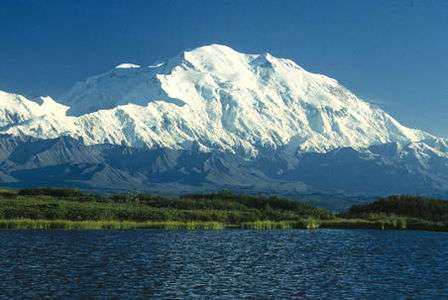
- 1. Denali in Alaska is the highest summit of the United States and all of North America.
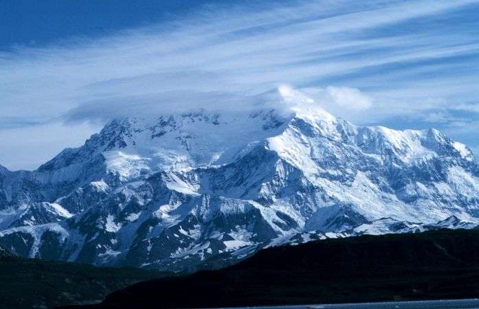 2. Mount Saint Elias is the second highest summit of both Canada and the United States.
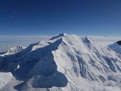 3. Mount Foraker is the second highest major summit of the Alaska Range.
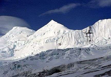 4. Mount Bona in Alaska is the highest volcano in the United States.
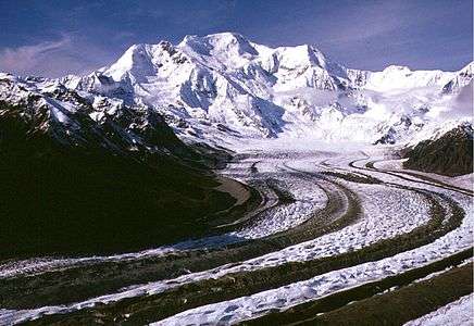 5. Mount Blackburn in Alaska is the highest summit of the Wrangell Mountains.
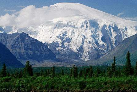 6. Mount Sanford in Alaska is the third highest volcano in the United States.
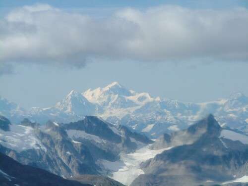 7. Mount Fairweather lies on the Alaska-British Columbia international border.
.jpg) 10. Mount Hunter is the third highest major summit of the Alaska Range.
10. Mount Hunter is the third highest major summit of the Alaska Range.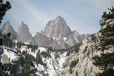 11. Mount Whitney highest summit of the Sierra Nevada and California.
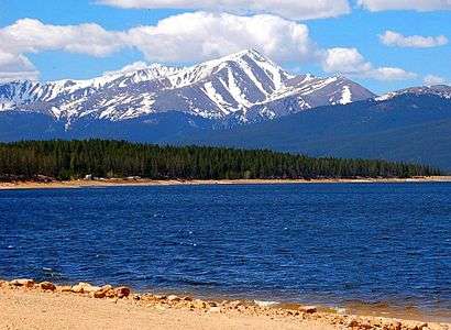 14. Mount Elbert is the highest summit of Colorado and the Rocky Mountains.
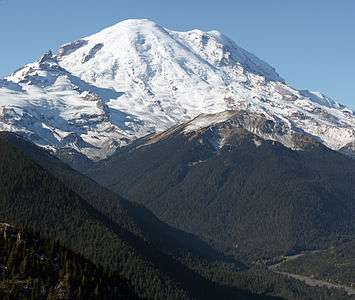 17. Mount Rainier is the highest summit of Washington and the Cascade Range.
 25. Grays Peak in Colorado is the highest point on the Continental Divide in North America.
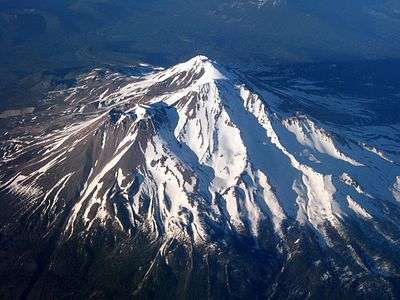 34. Mount Shasta in California is the highest summit of the southern Cascade Range.
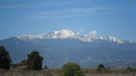 39. Pikes Peak in Colorado was the inspiration for America the Beautiful.
 54. Mount Hayes is the highest summit of the eastern Alaska Range.
 57. Gannett Peak is the highest summit of the Wind River Range and Wyoming.
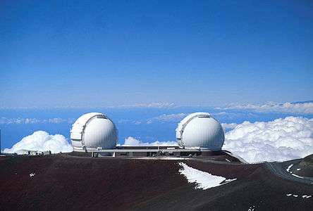 59. Mauna Kea on the Island of Hawaiʻi is the tallest mountain on Earth as measured from base to summit.
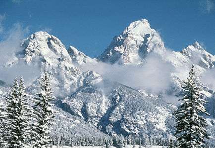 60. Grand Teton in Wyoming is the highest summit of the Teton Range.
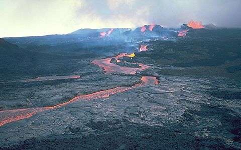 66. Mauna Loa on the Island of Hawaiʻi is the most voluminous mountain on Earth.
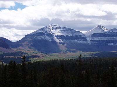 76. Kings Peak is the highest summit of the Uinta Range and Utah.
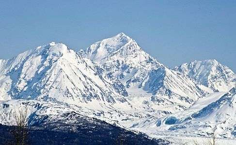 97. Mount Marcus Baker is the highest summit of the Chugach Mountains of Alaska.
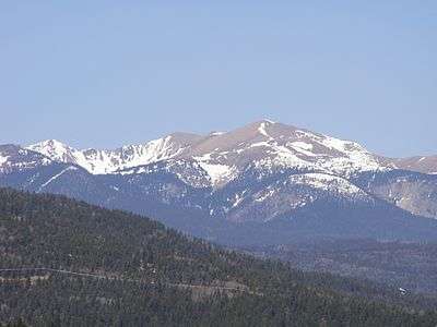 99. Wheeler Peak is the highest summit of New Mexico.
 117. Granite Peak is the highest summit of the Beartooth Range and Montana.
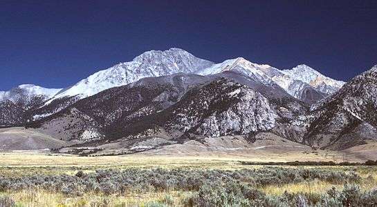 125. Borah Peak is the highest summit of the Lost River Range and Idaho.
 129. Humphreys Peak is the highest summit of the San Francisco Peaks and Arizona.
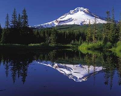 240. Mount Hood is the highest summit of Oregon.
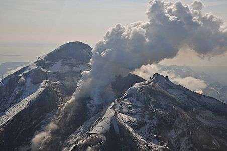 287. Redoubt Volcano is the highest summit of the Aleutian Range.
See also
- List of mountain peaks of North America
- List of mountain peaks of Greenland
- List of mountain peaks of Canada
- List of mountain peaks of the Rocky Mountains
- List of mountain peaks of the United States
- List of the highest major summits of the United States
- List of the major 4000-meter summits of the United States
- List of the major 3000-meter summits of the United States
- List of United States fourteeners
- List of the most prominent summits of the United States
- List of the most isolated major summits of the United States
- List of extreme summits of the United States
- List of mountain peaks of Alaska
- List of mountain peaks of California
- List of mountain peaks of Colorado
- List of mountain peaks of Hawaiʻi
- List of mountain peaks of Montana
- List of mountain peaks of Nevada
- List of mountain peaks of Utah
- List of mountain peaks of Washington
- List of mountain peaks of Wyoming
- List of the highest major summits of the United States
- List of mountain peaks of México
- List of mountain peaks of Central America
- List of mountain peaks of the Caribbean
- United States of America
- Geography of the United States
- Geology of the United States
- Category:Mountains of the United States
- Physical geography
References
- ↑ This article defines a significant summit as a summit with at least 100 meters (328.1 feet) of topographic prominence, and a major summit as a summit with at least 500 meters (1640 feet) of topographic prominence. All summits in this article have at least 500 meters of topographic prominence. An ultra-prominent summit is a summit with at least 1500 meters (4921 feet) of topographic prominence.
- ↑ All elevations in the 48 states of the contiguous United States include an elevation adjustment from the National Geodetic Vertical Datum of 1929 (NGVD 29) to the North American Vertical Datum of 1988 (NAVD 88). For further information, please see this United States National Geodetic Survey note.
- 1 2 If the elevation or prominence of a summit is calculated as a range of values, the arithmetic mean is shown.
- ↑ The topographic prominence of a summit is the topographic elevation difference between the summit and its highest or key col to a higher summit. The summit may be near its key col or quite far away. The key col for Denali in Alaska is the Isthmus of Rivas in Nicaragua, 7642 kilometers (4749 miles) away.
- ↑ The topographic isolation of a summit is the great-circle distance to its nearest point of equal elevation.
- ↑ The summit of Denali is the highest point of the Alaska Range, the State of Alaska, the United States of America, and greater North America. Denali is the third most topographically prominent and third most topographically isolated summit on Earth after Mount Everest and Aconcagua.
- ↑ Mount Saint Elias is the second highest major summit of both Canada and the United States.
- ↑ Mount Foraker is the westernmost 5000-meter (16,404-foot) summit of Alaska, the United States, and greater North America.
- ↑ The summit of Mount Bona is the highest point of the northwest Saint Elias Mountains.
- ↑ The summit of Mount Blackburn is the highest point of the Wrangell Mountains.
- ↑ "MT BLACKBURN". Datasheet for NGS Station UV4136. United States National Geodetic Survey. Retrieved 4 May 2016.
- ↑ Mount Fairweather lies on the international border between Alaska and British Columbia. The peak is the highest point of the Canadian Province of British Columbia and the southernmost and easternmost summit of its elevation in both Canada and the United States.
- ↑ The summit of Mount Whitney is the highest point of the Sierra Nevada, the State of California, and the contiguous United States.
- ↑ Mount Whitney is the southernmost and easternmost summit of its elevation in United States.
- ↑ "WHITNEY". Datasheet for NGS Station GT1811. United States National Geodetic Survey. Retrieved 4 May 2016.
- ↑ "BOUNDARY POINT 180". Datasheet for NGS Station UV3032. United States National Geodetic Survey. Retrieved 4 May 2016.
- ↑ The summit of Mount Elbert is the highest point of the U.S. State of Colorado, the Rocky Mountains of North America, and the entire Mississippi River drainage basin.
- ↑ "MOUNT ELBERT". Datasheet for NGS Station KL0637. United States National Geodetic Survey. Retrieved 4 May 2016.
- ↑ Mount Massive is the second highest major summit of the Rocky Mountains.
- ↑ "MOUNT MASSIVE CAIRN". Datasheet for NGS Station KL0640. United States National Geodetic Survey. Retrieved 4 May 2016.
- ↑ The elevation of Mount Massive includes an adjustment of +2.087 m (+6.85 ft) from NGVD 29 to NAVD 88.
- ↑ The summit of Mount Harvard is the highest point of the Collegiate Peaks.
- ↑ Mount Harvard is the southernmost and easternmost summit of its elevation in the Rocky Mountains.
- ↑ "HARVARD". Datasheet for NGS Station JL0879. United States National Geodetic Survey. Retrieved 4 May 2016.
- ↑ The summit of Mount Rainier is the highest point of the Cascade Range and the U.S. State of Washington. Mount Rainier is the most prominent summit in the contiguous United States and the fourth most prominent in North America.
- ↑ The elevation of Mount Rainier includes an adjustment of +1.914 m (+6.28 ft) from NGVD 29 to NAVD 88.
- ↑ The elevation of Mount Williamson includes an adjustment of +1.807 m (+5.93 ft) from NGVD 29 to NAVD 88.
- ↑ The summit of Blanca Peak is the highest point of the Sangre de Cristo Mountains and the entire Rio Grande drainage basin.
- ↑ Blanca Peak is the southernmost ultra-prominent summit of the Rocky Mountains.
- ↑ The elevation of Blanca Peak includes an adjustment of +1.755 m (+5.76 ft) from NGVD 29 to NAVD 88.
- ↑ The elevation of La Plata Peak includes an adjustment of +1.983 m (+6.51 ft) from NGVD 29 to NAVD 88.
- ↑ The summit of Uncompahgre Peak is the highest point of the San Juan Mountains and the entire Gulf of California drainage basin.
- ↑ Uncompahgre Peak is the westernmost summit of its elevation in the Rocky Mountains.
- ↑ "UNCOMPAHGRE". Datasheet for NGS Station JL0798. United States National Geodetic Survey. Retrieved 4 May 2016.
- ↑ The summit of Crestone Peak is the highest point of the Crestones.
- ↑ The elevation of Crestone Peak includes an adjustment of +1.76 m (+5.77 ft) from NGVD 29 to NAVD 88.
- ↑ The summit of Mount Lincoln is the highest point of the Mosquito Range and the entire Missouri River drainage basin.
- ↑ Mount Lincoln is the northernmost summit of its elevation in the Rocky Mountains.
- ↑ "MT LINCOLN". Datasheet for NGS Station KL0627. United States National Geodetic Survey. Retrieved 4 May 2016.
- ↑ The summit of Castle Peak is the highest point of the Elk Mountains.
- ↑ "CASTLE PK". Datasheet for NGS Station KL0659. United States National Geodetic Survey. Retrieved 4 May 2016.
- ↑ The summit of Grays Peak is the highest point of the Front Range and the Continental Divide in North America.
- ↑ Grays Peak is the northernmost summit of its elevation in the Rocky Mountains.
- ↑ "GRAYS PEAK". Datasheet for NGS Station KK2036. United States National Geodetic Survey. Retrieved 4 May 2016.
- ↑ The summit of Mount Antero is the highest point of the southern Sawatch Range.
- ↑ "MT ANTERO". Datasheet for NGS Station JL0883. United States National Geodetic Survey. Retrieved 4 May 2016.
- ↑ "EVANS". Datasheet for NGS Station KK2030. United States National Geodetic Survey. Retrieved 4 May 2016.
- ↑ The summit elevation of Mount Evans includes a vertical offset of +1.798 m (+5.9 ft) from the station benchmark.
- ↑ The summit of Longs Peak is the highest point of the northern Front Range.
- ↑ Longs Peak is the northernmost 14,000-foot (4267-meter) summit of the Rocky Mountains.
- ↑ "LONGS PEAK". Datasheet for NGS Station LL1346. United States National Geodetic Survey. Retrieved 4 May 2016.
- ↑ The summit of Mount Wilson is the highest point of the San Miguel Mountains.
- ↑ Mount Wilson is the westernmost summit of its elevation in the Rocky Mountains.
- ↑ The elevation of Mount Wilson includes an adjustment of +1.899 m (+6.23 ft) from NGVD 29 to NAVD 88.
- ↑ The summit of White Mountain Peak is the highest point of the White Mountains.
- ↑ "WHITE MOUNTAIN PEAK". Datasheet for NGS Station HR2559. United States National Geodetic Survey. Retrieved 4 May 2016.
- ↑ The summit of North Palisade is the highest point of the Palisades.
- ↑ "NORTH PALISADE". Datasheet for NGS Station HR2629. United States National Geodetic Survey. Retrieved 4 May 2016.
- ↑ The elevation of North Palisade includes an adjustment of +1.867 m (+6.13 ft) from NGVD 29 to NAVD 88.
- ↑ "PRINCETON". Datasheet for NGS Station JL0886. United States National Geodetic Survey. Retrieved 4 May 2016.
- ↑ "YALE". Datasheet for NGS Station JL0889. United States National Geodetic Survey. Retrieved 4 May 2016.
- ↑ The summit of Mount Shasta is the highest point of the southern Cascade Range.
- ↑ "MT SHASTA". Datasheet for NGS Station MX1016. United States National Geodetic Survey. Retrieved 4 May 2016.
- ↑ "MAROON PEAK". Datasheet for NGS Station KL0805. United States National Geodetic Survey. Retrieved 4 May 2016.
- ↑ The summit of Mount Sneffels is the highest point of the Sneffels Range.
- ↑ "SNEFFLES". Datasheet for NGS Station JL0826. United States National Geodetic Survey. Retrieved 4 May 2016.
- ↑ "CAPITOL PK". Datasheet for NGS Station KL0688. United States National Geodetic Survey. Retrieved 4 May 2016.
- ↑ The elevation of Capitol Peak includes an adjustment of +1.991 m (+6.53 ft) from NGVD 29 to NAVD 88.
- ↑ Pikes Peak is the easternmost 14,000-foot (4267-meter) summit and ultra-prominent summit of the Rocky Mountains. Pikes Peak was the inspiration for the lyrics of America the Beautiful.
- ↑ "PIKES PEAK". Datasheet for NGS Station JK1242. United States National Geodetic Survey. Retrieved 4 May 2016.
- ↑ The summit of Windom Peak is the highest point of the Needle Mountains.
- ↑ Mount Eolus may be higher than Windom Peak.
- ↑ The elevation of Windom Peak includes an adjustment of +1.785 m (+5.86 ft) from NGVD 29 to NAVD 88.
- ↑ "HANDIES". Datasheet for NGS Station HL0635. United States National Geodetic Survey. Retrieved 4 May 2016.
- ↑ The summit of Culebra Peak is the highest point of the Culebra Range.
- ↑ Culebra Peak is the southernmost 14,000-foot (4267-meter) summit of the Rocky Mountains.
- ↑ The elevation of Culebra Peak includes an adjustment of +1.740 m (+5.71 ft) from NGVD 29 to NAVD 88.
- ↑ The summit of San Luis Peak is the highest point of the La Garita Mountains.
- ↑ "SAN LUIS PEAK CAIRN". Datasheet for NGS Station HL0570. United States National Geodetic Survey. Retrieved 4 May 2016.
- ↑ The summit of Mount of the Holy Cross is the highest point of the northern Sawatch Range.
- ↑ "MT HOLY CROSS ET". Datasheet for NGS Station KL0649. United States National Geodetic Survey. Retrieved 4 May 2016.
- ↑ The summit elevation of Mount of the Holy Cross includes a vertical offset of +0.610 m (+2.0 ft) from the station benchmark.
- ↑ "GRIZZLY". Datasheet for NGS Station KL0800. United States National Geodetic Survey. Retrieved 4 May 2016.
- ↑ "MT HUMPHREYS". Datasheet for NGS Station HR2626. United States National Geodetic Survey. Retrieved 4 May 2016.
- ↑ The elevation of Mount Humphreys includes an adjustment of +1.842 m (+6.04 ft) from NGVD 29 to NAVD 88.
- ↑ "MT KEITH". Datasheet for NGS Station GT1807. United States National Geodetic Survey. Retrieved 4 May 2016.
- ↑ The elevation of Mount Keith includes an adjustment of +1.795 m (+5.89 ft) from NGVD 29 to NAVD 88.
- ↑ The summit of Mount Ouray is the highest point of the far southern Sawatch Range.
- ↑ "MOUNT OURAY RESET". Datasheet for NGS Station JL0672. United States National Geodetic Survey. Retrieved 4 May 2016.
- ↑ The elevation of Vermilion Peak includes an adjustment of +1.827 m (+5.99 ft) from NGVD 29 to NAVD 88.
- ↑ "REGAL MOUNTAIN". Datasheet for NGS Station UV4133. United States National Geodetic Survey. Retrieved 4 May 2016.
- ↑ "MT DARWIN". Datasheet for NGS Station HR2631. United States National Geodetic Survey. Retrieved 4 May 2016.
- ↑ The elevation of Mount Darwin includes an adjustment of +1.886 m (+6.19 ft) from NGVD 29 to NAVD 88.
- ↑ The summit of Mount Hayes is the highest point of the Hayes Range.
- ↑ Mount Hayes is the northernmost 4000-meter (13,123-foot) summit of Alaska, the United States, and greater North America.
- ↑ "SILVERHEELS ET". Datasheet for NGS Station KL0629. United States National Geodetic Survey. Retrieved 4 May 2016.
- ↑ "PYRAMID". Datasheet for NGS Station HL0589. United States National Geodetic Survey. Retrieved 4 May 2016.
- ↑ The summit of Gannett Peak is the highest point of the Wind River Range, the U.S. State of Wyoming, and the central Rocky Mountains.
- ↑ Gannett Peak is the northernmost and westernmost summit of its elevation in the Rocky Mountains.
- ↑ "GANNETT PEAK CAIRN". Datasheet for NGS Station OW0356. United States National Geodetic Survey. Retrieved 4 May 2016.
- ↑ The summit of Mount Kaweah is the highest point of the Great Western Divide.
- ↑ Mount Kaweah is the southernmost summit of its elevation in United States.
- ↑ The elevation of Mount Kaweah includes an adjustment of +1.652 m (+5.42 ft) from NGVD 29 to NAVD 88.
- ↑ The summit of Mauna Kea is the highest point of the Island of Hawaiʻi, the U.S. State of Hawaiʻi, and all islands of the Pacific Ocean.
- ↑ Mauna Kea is the tallest mountain on Earth as measured from base to summit. The shield volcano sits on the ocean floor at a depth of 5998 meters (19,678 feet) for a total height of 10,205.3 meters (33,482 feet).
- ↑ "SUMMIT". Datasheet for NGS Station TU2314. United States National Geodetic Survey. Retrieved 4 May 2016.
- ↑ The summit of Grand Teton is the highest point of the Teton Range.
- ↑ Grand Teton is the northernmost and westernmost 4000-meter (13,123-foot) summit of the Rocky Mountains.
- ↑ "GRAND TETON". Datasheet for NGS Station OX0838. United States National Geodetic Survey. Retrieved 4 May 2016.
- ↑ "MORGAN". Datasheet for NGS Station HR2627. United States National Geodetic Survey. Retrieved 4 May 2016.
- ↑ The elevation of Mount Gabb includes an adjustment of +1.958 m (+6.42 ft) from NGVD 29 to NAVD 88.
- ↑ The elevation of Bald Mountain includes an adjustment of +1.922 m (+6.31 ft) from NGVD 29 to NAVD 88.
- ↑ The elevation of Mount Oso includes an adjustment of +1.776 m (+5.83 ft) from NGVD 29 to NAVD 88.
- ↑ Mauna Loa is the southernmost and westernmost 4000-meter (13,123-foot) summit of Hawaiʻi and the United States.
- ↑ The shield volcano Mauna Loa is the most voluminous mountain on Earth with an estimated volume of 74,000 km³ (17,800 cubic miles), or enough material to fill the Grand Canyon more than 18 times.
- ↑ "MT JACKSON ET". Datasheet for NGS Station KL0650. United States National Geodetic Survey. Retrieved 4 May 2016.
- ↑ "MT TOM LOOKOUT TOWER". Datasheet for NGS Station HR2770. United States National Geodetic Survey. Retrieved 4 May 2016.
- ↑ The elevation of Mount Tom includes an adjustment of +1.379 m (+4.52 ft) from NGVD 29 to NAVD 88.
- ↑ The elevation of Bard Peak includes an adjustment of +1.707 m (+5.60 ft) from NGVD 29 to NAVD 88.
- ↑ West Spanish Peak is the easternmost 4000-meter (13,123-foot) summit of the Rocky Mountains and the United States.
- ↑ The elevation of West Spanish Peak includes an adjustment of +1.468 m (+4.82 ft) from NGVD 29 to NAVD 88.
- ↑ The summit of Mount Powell is the highest point of the Gore Range.
- ↑ The elevation of Mount Powell includes an adjustment of +1.771 m (+5.81 ft) from NGVD 29 to NAVD 88.
- ↑ The summit of Hagues Peak is the highest point of the Mummy Range.
- ↑ "HAGUE RM". Datasheet for NGS Station LL1350. United States National Geodetic Survey. Retrieved 4 May 2016.
- ↑ The elevation of Mount Dubois includes an adjustment of +1.879 m (+6.16 ft) from NGVD 29 to NAVD 88.
- ↑ The elevation of Tower Mountain includes an adjustment of +1.796 m (+5.89 ft) from NGVD 29 to NAVD 88.
- ↑ The elevation of Treasure Mountain includes an adjustment of +2.008 m (+6.59 ft) from NGVD 29 to NAVD 88.
- ↑ The summit of Kings Peak is the highest point of the Uinta Mountains, the U.S. State of Utah, and the western Rocky Mountains.
- ↑ The elevation of Kings Peak includes an adjustment of +1.807 m (+5.93 ft) from NGVD 29 to NAVD 88.
- ↑ The summit of North Arapaho Peak is the highest point of the Indian Peaks.
- ↑ "NORTH ARAPAHOE PEAK CAIRN". Datasheet for NGS Station LL1357. United States National Geodetic Survey. Retrieved 4 May 2016.
- ↑ The elevation of North Arapaho Peak includes an adjustment of +1.763 m (+5.78 ft) from NGVD 29 to NAVD 88.
- ↑ The elevation of Mount Pinchot includes an adjustment of +1.810 m (+5.94 ft) from NGVD 29 to NAVD 88.
- ↑ The elevation of Parry Peak includes an adjustment of +1.763 m (+5.78 ft) from NGVD 29 to NAVD 88.
- ↑ The summit of Bill Williams Peak is the highest point of the Williams Mountains.
- ↑ The elevation of Bill Williams Peak includes an adjustment of +2.044 m (+6.71 ft) from NGVD 29 to NAVD 88.
- ↑ The elevation of Sultan Mountain includes an adjustment of +1.649 m (+5.41 ft) from NGVD 29 to NAVD 88.
- ↑ The elevation of Mount Herard includes an adjustment of +1.640 m (+5.38 ft) from NGVD 29 to NAVD 88.
- ↑ "BUFFALO WEST PEAK CAIRN". Datasheet for NGS Station JL0653. United States National Geodetic Survey. Retrieved 4 May 2016.
- ↑ The elevation of West Buffalo Peak includes an adjustment of +1.834 m (+6.02 ft) from NGVD 29 to NAVD 88.
- ↑ The summit of Summit Peak is the highest point of the southern San Juan Mountains.
- ↑ "SUMMIT". Datasheet for NGS Station HL0503. United States National Geodetic Survey. Retrieved 4 May 2016.
- ↑ Dolores Peak may be higher than Middle Peak.
- ↑ The elevation of Middle Peak includes an adjustment of +1.809 m (+5.94 ft) from NGVD 29 to NAVD 88.
- ↑ The elevation of Antora Peak includes an adjustment of +1.883 m (+6.18 ft) from NGVD 29 to NAVD 88.
- ↑ The elevation of Henry Mountain includes an adjustment of +2.037 m (+6.68 ft) from NGVD 29 to NAVD 88.
- ↑ The summit of Hesperus Mountain is the highest point of the La Plata Mountains.
- ↑ The elevation of Hesperus Mountain includes an adjustment of +1.650 m (+5.41 ft) from NGVD 29 to NAVD 88.
- ↑ The elevation of Jacque Peak includes an adjustment of +1.866 m (+6.12 ft) from NGVD 29 to NAVD 88.
- ↑ The elevation of Bennett Peak includes an adjustment of +1.782 m (+5.85 ft) from NGVD 29 to NAVD 88.
- ↑ The summit of Wind River Peak is the highest point of the southern Wind River Range.
- ↑ "WIND". Datasheet for NGS Station NS0274. United States National Geodetic Survey. Retrieved 4 May 2016.
- ↑ "CONEJOS". Datasheet for NGS Station HL0502. United States National Geodetic Survey. Retrieved 4 May 2016.
- ↑ The summit of Mount Marcus Baker is the highest point of the Chugach Mountains.
- ↑ The summit of Cloud Peak is the highest point of the Bighorn Mountains.
- ↑ Cloud Peak is the northernmost 4000-meter (13,123-foot) summit of the Rocky Mountains.
- ↑ "CLOUD PEAK". Datasheet for NGS Station PW0524. United States National Geodetic Survey. Retrieved 4 May 2016.
- ↑ The summit of Wheeler Peak is the highest point of the Taos Mountains and the U.S. State of New Mexico.
- ↑ Wheeler Peak is the southernmost 4000-meter (13,123-foot) summit of the Rocky Mountains.
- ↑ "WHEELER". Datasheet for NGS Station GM0779. United States National Geodetic Survey. Retrieved 4 May 2016.
- ↑ The summit of Francs Peak is the highest point of the Absaroka Range.
- ↑ "FRANCS PK 2". Datasheet for NGS Station OW0325. United States National Geodetic Survey. Retrieved 4 May 2016.
- ↑ The summit of Twilight Peak is the highest point of the West Needle Mountains.
- ↑ The elevation of Twilight Peak includes an adjustment of +1.537 m (+5.04 ft) from NGVD 29 to NAVD 88.
- ↑ "S RIVER". Datasheet for NGS Station HL0558. United States National Geodetic Survey. Retrieved 4 May 2016.
- ↑ The summit of Mount Ritter is the highest point of the Ritter Range.
- ↑ The elevation of Mount Ritter includes an adjustment of +1.786 m (+5.86 ft) from NGVD 29 to NAVD 88.
- ↑ "RED SLATE MOUNTAIN". Datasheet for NGS Station HR2690. United States National Geodetic Survey. Retrieved 4 May 2016.
- ↑ The elevation of Red Slate Mountain includes an adjustment of +1.893 m (+6.21 ft) from NGVD 29 to NAVD 88.
- ↑ "LYELL 2". Datasheet for NGS Station HR2884. United States National Geodetic Survey. Retrieved 4 May 2016.
- ↑ "TWIN". Datasheet for NGS Station JK1305. United States National Geodetic Survey. Retrieved 4 May 2016.
- ↑ The summit of Truchas Peak is the highest point of the Santa Fe Mountains.
- ↑ Truchas Peak is the southernmost summit of its elevation in the Rocky Mountains.
- ↑ "TRUCHAS". Datasheet for NGS Station FN0666. United States National Geodetic Survey. Retrieved 4 May 2016.
- ↑ The summit of Wheeler Peak is the highest point of the Snake Range.
- ↑ "WHEELER PEAK". Datasheet for NGS Station JP0339. United States National Geodetic Survey. Retrieved 4 May 2016.
- ↑ "MOUNT DANA". Datasheet for NGS Station HR2738. United States National Geodetic Survey. Retrieved 4 May 2016.
- ↑ The summit of West Elk Peak is the highest point of the West Elk Mountains.
- ↑ "WEST ELK D". Datasheet for NGS Station JL0755. United States National Geodetic Survey. Retrieved 4 May 2016.
- ↑ The elevation of Mount Centennial includes an adjustment of +1.814 m (+5.95 ft) from NGVD 29 to NAVD 88.
- ↑ The summit of Clark Peak is the highest point of the Medicine Bow Mountains.
- ↑ "CLARK". Datasheet for NGS Station LL1388. United States National Geodetic Survey. Retrieved 4 May 2016.
- ↑ The summit of Mount Richthofen is the highest point of the Never Summer Mountains.
- ↑ The elevation of Mount Richthofen includes an adjustment of +1.658 m (+5.44 ft) from NGVD 29 to NAVD 88.
- ↑ The summit of Lizard Head Peak is the highest point of the Cirque of the Towers.
- ↑ The elevation of Lizard Head Peak includes an adjustment of +1.572 m (+5.16 ft) from NGVD 29 to NAVD 88.
- ↑ The summit of Granite Peak is the highest point of the Beartooth Mountains and the U.S. State of Montana.
- ↑ "GRANITE PEAK". Datasheet for NGS Station QW0616. United States National Geodetic Survey. Retrieved 4 May 2016.
- ↑ The elevation of Venado Peak includes an adjustment of +1.650 m (+5.41 ft) from NGVD 29 to NAVD 88.
- ↑ "CHAIR D". Datasheet for NGS Station KL0696. United States National Geodetic Survey. Retrieved 4 May 2016.
- ↑ The summit of Mount Peale is the highest point of the La Sal Mountains and the Colorado Plateau.
- ↑ "MOUNT PEALE". Datasheet for NGS Station JM0496. United States National Geodetic Survey. Retrieved 4 May 2016.
- ↑ "GUNNISON D". Datasheet for NGS Station JL0762. United States National Geodetic Survey. Retrieved 4 May 2016.
- ↑ East Spanish Peak is the easternmost 3000-meter (9843-foot) summit of the Rocky Mountains and the United States.
- ↑ "EAST SPANISH PEAK CAIRN". Datasheet for NGS Station HK0488. United States National Geodetic Survey. Retrieved 4 May 2016.
- ↑ The elevation of East Spanish Peak includes an adjustment of +1.372 m (+4.50 ft) from NGVD 29 to NAVD 88.
- ↑ The summit of Borah Peak is the highest point of the Lost River Range and the U.S. State of Idaho.
- ↑ "BEAUTY RESET". Datasheet for NGS Station PZ0770. United States National Geodetic Survey. Retrieved 4 May 2016.
- ↑ The summit of Mount Wood is the highest point of the Granite Range.
- ↑ The elevation of Mount Wood includes an adjustment of +1.516 m (+4.97 ft) from NGVD 29 to NAVD 88.
- ↑ "MOUNT CONNESS". Datasheet for NGS Station HR2743. United States National Geodetic Survey. Retrieved 4 May 2016.
- ↑ The summit of Humphreys Peak is the highest point of the San Francisco Peaks and the U.S. State of Arizona.
- ↑ The elevation of Humphreys Peak includes an adjustment of +1.345 m (+4.41 ft) from NGVD 29 to NAVD 88.
- ↑ Santa Fe Baldy is the southernmost 3000-meter (9843-foot) summit of the Rocky Mountains.
- ↑ "SANTA FE BALDY". Datasheet for NGS Station FN0726. United States National Geodetic Survey. Retrieved 4 May 2016.
- ↑ The elevation of Gothic Mountain includes an adjustment of +1.936 m (+6.35 ft) from NGVD 29 to NAVD 88.
- ↑ "PLATEAU". Datasheet for NGS Station QW0613. United States National Geodetic Survey. Retrieved 4 May 2016.
- ↑ "LONE CONE". Datasheet for NGS Station HM0489. United States National Geodetic Survey. Retrieved 4 May 2016.
- ↑ "MT MORAN ET". Datasheet for NGS Station OX0854. United States National Geodetic Survey. Retrieved 4 May 2016.
- ↑ "CUERVO". Datasheet for NGS Station GM0770. United States National Geodetic Survey. Retrieved 4 May 2016.
- ↑ The elevation of Needham Mountain includes an adjustment of +1.602 m (+5.26 ft) from NGVD 29 to NAVD 88.
- ↑ "GRAHAM". Datasheet for NGS Station HL0620. United States National Geodetic Survey. Retrieved 4 May 2016.
- ↑ "WHETSTONE MTN CAIRN". Datasheet for NGS Station JL0732. United States National Geodetic Survey. Retrieved 4 May 2016.
- ↑ The elevation of Atlantic Peak includes an adjustment of +1.521 m (+4.99 ft) from NGVD 29 to NAVD 88.
- ↑ The elevation of Specimen Mountain includes an adjustment of +1.614 m (+5.30 ft) from NGVD 29 to NAVD 88.
- ↑ The summit of Baldy Mountain is the highest point of the Cimarron Range.
- ↑ "BALDY MTN". Datasheet for NGS Station GM0775. United States National Geodetic Survey. Retrieved 4 May 2016.
- ↑ "EAST BECKWITH". Datasheet for NGS Station JL0741. United States National Geodetic Survey. Retrieved 4 May 2016.
- ↑ The summit of Knobby Crest is the highest point of the Kenosha Mountains.
- ↑ The elevation of Knobby Crest includes an adjustment of +1.595 m (+5.23 ft) from NGVD 29 to NAVD 88.
- ↑ The summit of Bison Peak is the highest point of the Tarryall Mountains.
- ↑ "BISON". Datasheet for NGS Station KK1966. United States National Geodetic Survey. Retrieved 4 May 2016.
- ↑ "ANTHRACITE". Datasheet for NGS Station JL0739. United States National Geodetic Survey. Retrieved 4 May 2016.
- ↑ The elevation of Matchless Mountain includes an adjustment of +1.941 m (+6.37 ft) from NGVD 29 to NAVD 88.
- ↑ The summit of Flat Top Mountain is the highest point of the Flat Tops.
- ↑ "FLATTOP". Datasheet for NGS Station LM0694. United States National Geodetic Survey. Retrieved 4 May 2016.
- ↑ "MT NYSTROM". Datasheet for NGS Station NS0271. United States National Geodetic Survey. Retrieved 4 May 2016.
- ↑ The summit of Greenhorn Mountain is the highest point of the Wet Mountains.
- ↑ "GREENHORN MTN". Datasheet for NGS Station HK0512. United States National Geodetic Survey. Retrieved 4 May 2016.
- ↑ The elevation of Elliott Mountain includes an adjustment of +1.709 m (+5.61 ft) from NGVD 29 to NAVD 88.
- ↑ Mount Deborah is the northernmost summit of its elevation in Alaska, the United States, and greater North America.
- ↑ The elevation of Twin Peaks includes an adjustment of +1.717 m (+5.63 ft) from NGVD 29 to NAVD 88.
- ↑ "CARTER". Datasheet for NGS Station PX0432. United States National Geodetic Survey. Retrieved 4 May 2016.
- ↑ The summit of Parkview Mountain is the highest point of the Rabbit Ears Range.
- ↑ "PARKVIEW MOUNTAIN". Datasheet for NGS Station LM0574. United States National Geodetic Survey. Retrieved 4 May 2016.
- ↑ The elevation of Cornwall Mountain includes an adjustment of +1.715 m (+5.63 ft) from NGVD 29 to NAVD 88.
- ↑ "MOUNT ADAMS". Datasheet for NGS Station SB1004. United States National Geodetic Survey. Retrieved 4 May 2016.
- ↑ The summit of Trout Peak is the highest point of the central Absaroka Range.
- ↑ "TROUT". Datasheet for NGS Station PX0457. United States National Geodetic Survey. Retrieved 4 May 2016.
- ↑ The summit of Diamond Peak is the highest point of the Lemhi Range.
- ↑ "DIAMOND RESET". Datasheet for NGS Station PZ0750. United States National Geodetic Survey. Retrieved 4 May 2016.
- ↑ The summit of Mount Zirkel is the highest point of the Park Range.
- ↑ The elevation of Mount Zirkel includes an adjustment of +1.632 m (+5.35 ft) from NGVD 29 to NAVD 88.
- ↑ The summit of Delano Peak is the highest point of the Tushar Mountains.
- ↑ "DELANO PEAK M 5". Datasheet for NGS Station JO0502. United States National Geodetic Survey. Retrieved 4 May 2016.
- ↑ The elevation of Crested Butte includes an adjustment of +1.940 m (+6.36 ft) from NGVD 29 to NAVD 88.
- ↑ "YOUNTS". Datasheet for NGS Station OW0379. United States National Geodetic Survey. Retrieved 4 May 2016.
- ↑ "SAWTOOTH". Datasheet for NGS Station JL0697. United States National Geodetic Survey. Retrieved 4 May 2016.
- ↑ The summit of Olancha Peak is the highest point of the southern Sierra Nevada.
- ↑ "OLANCHA". Datasheet for NGS Station GT1820. United States National Geodetic Survey. Retrieved 4 May 2016.
- ↑ The elevation of Park Cone includes an adjustment of +1.873 m (+6.15 ft) from NGVD 29 to NAVD 88.
- ↑ The summit of Ibapah Peak is the highest point of the Deep Creek Range.
- ↑ The elevation of Ibapah Peak includes an adjustment of +1.517 m (+4.98 ft) from NGVD 29 to NAVD 88.
- ↑ "CARBON". Datasheet for NGS Station JL0738. United States National Geodetic Survey. Retrieved 4 May 2016.
- ↑ The elevation of Glover Peak includes an adjustment of +1.609 m (+5.28 ft) from NGVD 29 to NAVD 88.
- ↑ "MT MORIAH". Datasheet for NGS Station KP0314. United States National Geodetic Survey. Retrieved 4 May 2016.
- ↑ "MT GUERO". Datasheet for NGS Station JL0894. United States National Geodetic Survey. Retrieved 4 May 2016.
- ↑ "RUEDI". Datasheet for NGS Station KL0811. United States National Geodetic Survey. Retrieved 4 May 2016.
- ↑ "CHALK". Datasheet for NGS Station HL0510. United States National Geodetic Survey. Retrieved 4 May 2016.
- ↑ The summit of Medicine Bow Peak is the highest point of the Snowy Range.
- ↑ "MEDICINE BOW". Datasheet for NGS Station MP0546. United States National Geodetic Survey. Retrieved 4 May 2016.
- ↑ The elevation of Mount Zwischen includes an adjustment of +1.481 m (+4.86 ft) from NGVD 29 to NAVD 88.
- ↑ "LITTLE CONE". Datasheet for NGS Station HM0486. United States National Geodetic Survey. Retrieved 4 May 2016.
- ↑ The summit of Sierra Blanca Peak is the highest point of the Sacramento Mountains.
- ↑ "SIERRA BLANCA". Datasheet for NGS Station DR1010. United States National Geodetic Survey. Retrieved 4 May 2016.
- ↑ The summit of Mount Jefferson is the highest point of the Toquima Range.
- ↑ The elevation of Mount Jefferson includes an adjustment of +1.666 m (+5.47 ft) from NGVD 29 to NAVD 88.
- ↑ Hess Mountain is the northernmost 3000-meter (9843-foot) summit of Alaska and the United States.
- ↑ "MT BROOKS". Datasheet for NGS Station TT6450. United States National Geodetic Survey. Retrieved 4 May 2016.
- ↑ The summit of Cerro Vista is the highest point of the southern Sangre de Cristo Range.
- ↑ "CERRO". Datasheet for NGS Station GM0798. United States National Geodetic Survey. Retrieved 4 May 2016.
- ↑ The summit of Mount Nebo is the highest point of the Wasatch Range.
- ↑ The elevation of Mount Nebo includes an adjustment of +1.395 m (+4.58 ft) from NGVD 29 to NAVD 88.
- ↑ The summit of Charleston Peak is the highest point of the Spring Mountains.
- ↑ "CHARLESTON". Datasheet for NGS Station GR1965. United States National Geodetic Survey. Retrieved 4 May 2016.
- ↑ The summit of North Schell Peak is the highest point of the Schell Creek Range.
- ↑ "NORTH SHELL". Datasheet for NGS Station KP0332. United States National Geodetic Survey. Retrieved 4 May 2016.
- ↑ The elevation of Huntsman Ridge includes an adjustment of +1.711 m (+5.61 ft) from NGVD 29 to NAVD 88.
- ↑ "BUFFALO". Datasheet for NGS Station LM0590. United States National Geodetic Survey. Retrieved 4 May 2016.
- ↑ The summit of Castle Peak is the highest point of the White Cloud Mountains.
- ↑ "CASTLE". Datasheet for NGS Station QA0732. United States National Geodetic Survey. Retrieved 4 May 2016.
- ↑ The summit of Arc Dome is the highest point of the Toiyabe Range.
- ↑ The elevation of Arc Dome includes an adjustment of +1.665 m (+5.46 ft) from NGVD 29 to NAVD 88.
- ↑ The summit of Mount Timpanogos is the highest point of the central Wasatch Range.
- ↑ "TIMPANOGOS". Datasheet for NGS Station LO0769. United States National Geodetic Survey. Retrieved 4 May 2016.
- ↑ The summit of Waugh Mountain is the highest point of the South Park Hills.
- ↑ The elevation of Waugh Mountain includes an adjustment of +1.702 m (+5.58 ft) from NGVD 29 to NAVD 88.
- ↑ The elevation of Coal Mountain includes an adjustment of +1.625 m (+5.33 ft) from NGVD 29 to NAVD 88.
- ↑ The summit of Mount Patterson is the highest point of the Sweetwater Range.
- ↑ The elevation of Mount Patterson includes an adjustment of +1.734 m (+5.69 ft) from NGVD 29 to NAVD 88.
- ↑ Mount Russell is the westernmost summit of its elevation in Alaska and greater North America.
- ↑ The elevation of Black Mountain includes an adjustment of +1.631 m (+5.35 ft) from NGVD 29 to NAVD 88.
- ↑ "WILLIAMS". Datasheet for NGS Station KL0783. United States National Geodetic Survey. Retrieved 4 May 2016.
- ↑ The elevation of Puma Peak includes an adjustment of +1.513 m (+4.96 ft) from NGVD 29 to NAVD 88.
- ↑ The elevation of Mount Mestas includes an adjustment of +1.372 m (+4.50 ft) from NGVD 29 to NAVD 88.
- ↑ The summit of Chicoma Mountain is the highest point of the Jemez Mountains.
- ↑ "LANGLEY". Datasheet for NGS Station GN0677. United States National Geodetic Survey. Retrieved 4 May 2016.
- ↑ The elevation of Thirtynine Mile Mountain includes an adjustment of +1.584 m (+5.20 ft) from NGVD 29 to NAVD 88.
- ↑ The summit of Mount Ellen is the highest point of the Henry Mountains.
- ↑ The elevation of Mount Ellen includes an adjustment of +1.486 m (+4.88 ft) from NGVD 29 to NAVD 88.
- ↑ The summit of Currant Mountain is the highest point of the White Pine Range.
- ↑ "CURRANT MT". Datasheet for NGS Station JP0700. United States National Geodetic Survey. Retrieved 4 May 2016.
- ↑ The summit of San Gorgonio Mountain is the highest point of the San Bernardino Mountains.
- ↑ The elevation of San Gorgonio Mountain includes an adjustment of +1.303 m (+4.27 ft) from NGVD 29 to NAVD 88.
- ↑ The elevation of Tomichi Dome includes an adjustment of +1.693 m (+5.55 ft) from NGVD 29 to NAVD 88.
- ↑ The summit of Blair Mountain is the highest point of the White River Plateau.
- ↑ The elevation of Blair Mountain includes an adjustment of +1.565 m (+5.13 ft) from NGVD 29 to NAVD 88.
- ↑ The elevation of Twin Sisters Peaks includes an adjustment of +1.388 m (+4.55 ft) from NGVD 29 to NAVD 88.
- ↑ "ELK". Datasheet for NGS Station LM0582. United States National Geodetic Survey. Retrieved 4 May 2016.
- ↑ The summit of Wyoming Peak is the highest point of the Wyoming Range.
- ↑ "WYOMING PEAK". Datasheet for NGS Station NT0655. United States National Geodetic Survey. Retrieved 4 May 2016.
- ↑ The elevation of Iron Mountain includes an adjustment of +1.436 m (+4.71 ft) from NGVD 29 to NAVD 88.
- ↑ The summit of Mount Torbert is the highest point of the Tordrillo Mountains.
- ↑ Mount Torbert is the westernmost summit of its elevation in Alaska and greater North America.
- ↑ The summit of Mount Baldy is the highest point of the White Mountains.
- ↑ "BALDY". Datasheet for NGS Station DT0788. United States National Geodetic Survey. Retrieved 4 May 2016.
- ↑ The summit of Ruby Dome is the highest point of the Ruby Mountains.
- ↑ "RUBY DOME CAIRN". Datasheet for NGS Station LQ0693. United States National Geodetic Survey. Retrieved 4 May 2016.
- ↑ The elevation of Ruby Dome includes an adjustment of +1.429 m (+4.69 ft) from NGVD 29 to NAVD 88.
- ↑ The summit of Abajo Peak is the highest point of the Abajo Mountains.
- ↑ "ABAJO PEAK". Datasheet for NGS Station HM0536. United States National Geodetic Survey. Retrieved 4 May 2016.
- ↑ The elevation of Marcellina Mountain includes an adjustment of +1.658 m (+5.44 ft) from NGVD 29 to NAVD 88.
- ↑ The summit of Crater Peak is the highest point of Grand Mesa.
- ↑ "CRATER PK". Datasheet for NGS Station KL0706. United States National Geodetic Survey. Retrieved 4 May 2016.
- ↑ The summit of Hilgard Peak is the highest point of the Madison Range.
- ↑ The elevation of Hilgard Peak includes an adjustment of +1.490 m (+4.89 ft) from NGVD 29 to NAVD 88.
- ↑ The summit of Brian Head is the highest point of the Markagunt Plateau.
- ↑ The elevation of Brian Head includes an adjustment of +1.556 m (+5.10 ft) from NGVD 29 to NAVD 88.
- ↑ The summit of Hole in the Mountain Peak is the highest point of the eastern Humboldt Range.
- ↑ The elevation of Hole in the Mountain Peak includes an adjustment of +1.457 m (+4.78 ft) from NGVD 29 to NAVD 88.
- ↑ The summit of Mount Taylor is the highest point of the northern San Mateo Mountains.
- ↑ "TAYLOR". Datasheet for NGS Station FO1614. United States National Geodetic Survey. Retrieved 4 May 2016.
- ↑ The elevation of Castle Peak includes an adjustment of +1.575 m (+5.17 ft) from NGVD 29 to NAVD 88.
- ↑ The summit of Troy Peak is the highest point of the Grant Range.
- ↑ "WHITE PINE RESET". Datasheet for NGS Station JP0387. United States National Geodetic Survey. Retrieved 4 May 2016.
- ↑ The summit of South Tent Mountain is the highest point of the Wasatch Plateau.
- ↑ "SOUTH TENT". Datasheet for NGS Station KN0397. United States National Geodetic Survey. Retrieved 4 May 2016.
- ↑ The summit of Mount Hood is the highest point of the Oregon Cascades and the U.S. State of Oregon.
- ↑ "MOUNT HOOD HIGHEST POINT". Datasheet for NGS Station RC2244. United States National Geodetic Survey. Retrieved 4 May 2016.
- ↑ The summit of Crazy Peak is the highest point of the Crazy Mountains.
- ↑ The elevation of Crazy Peak includes an adjustment of +1.421 m (+4.66 ft) from NGVD 29 to NAVD 88.
- ↑ The elevation of Hardscrabble Mountain includes an adjustment of +1.612 m (+5.29 ft) from NGVD 29 to NAVD 88.
- ↑ The summit of Tweedy Mountain is the highest point of the Pioneer Mountains.
- ↑ "TWEEDY MTN SOUTH PEAK". Datasheet for NGS Station QY0549. United States National Geodetic Survey. Retrieved 4 May 2016.
- ↑ The elevation of Tweedy Mountain includes an adjustment of +1.598 m (+5.24 ft) from NGVD 29 to NAVD 88.
- ↑ The elevation of Cochetopa Dome includes an adjustment of +1.804 m (+5.92 ft) from NGVD 29 to NAVD 88.
- ↑ The summit of Waucoba Mountain is the highest point of the Inyo Mountains.
- ↑ "WAUCOBA". Datasheet for NGS Station HR2612. United States National Geodetic Survey. Retrieved 4 May 2016.
- ↑ The summit of Glass Mountain is the highest point of the Glass Mountain Ridge.
- ↑ "GLASS MOUNTAIN". Datasheet for NGS Station HR2673. United States National Geodetic Survey. Retrieved 4 May 2016.
- ↑ "NORTH MAM". Datasheet for NGS Station KL0716. United States National Geodetic Survey. Retrieved 4 May 2016.
- ↑ The elevation of Keynot Peak includes an adjustment of +1.347 m (+4.42 ft) from NGVD 29 to NAVD 88.
- ↑ The summit of Telescope Peak is the highest point of the Panamint Range.
- ↑ "TELESCOPE". Datasheet for NGS Station GS0799. United States National Geodetic Survey. Retrieved 4 May 2016.
- ↑ The elevation of Mammoth Mountain includes an adjustment of +1.766 m (+5.79 ft) from NGVD 29 to NAVD 88.
- ↑ The summit of Deseret Peak is the highest point of the Stansbury Mountains.
- ↑ The elevation of Laramie Mountains high point includes an adjustment of +1.415 m (+4.64 ft) from NGVD 29 to NAVD 88.
- ↑ The summit of Freel Peak is the highest point of the Carson Range.
- ↑ "FREEL PEAK". Datasheet for NGS Station JR1221. United States National Geodetic Survey. Retrieved 4 May 2016.
- ↑ The summit of Sand Mountain North is the highest point of the Elkhead Mountains.
- ↑ The elevation of Sand Mountain North includes an adjustment of +1.502 m (+4.93 ft) from NGVD 29 to NAVD 88.
- ↑ The elevation of Black Mountain includes an adjustment of +1.537 m (+5.04 ft) from NGVD 29 to NAVD 88.
- ↑ The elevation of Sleepy Cat Peak includes an adjustment of +1.471 m (+4.83 ft) from NGVD 29 to NAVD 88.
- ↑ The summit of Matterhorn is the highest point of the Jarbidge Mountains.
- ↑ The elevation of Matterhorn includes an adjustment of +1.429 m (+4.69 ft) from NGVD 29 to NAVD 88.
- ↑ "SPRUCE MTN". Datasheet for NGS Station KL0703. United States National Geodetic Survey. Retrieved 4 May 2016.
- ↑ The summit of San Jacinto Peak is the highest point of the San Jacinto Mountains.
- ↑ "SAN JACINTO". Datasheet for NGS Station DX5119. United States National Geodetic Survey. Retrieved 4 May 2016.
- ↑ The summit of West Goat Peak is the highest point of the Anaconda Range.
- ↑ The elevation of West Goat Peak includes an adjustment of +1.520 m (+4.99 ft) from NGVD 29 to NAVD 88.
- ↑ The summit of South Baldy is the highest point of the Magdalena Mountains.
- ↑ "SOUTH". Datasheet for NGS Station DS1463. United States National Geodetic Survey. Retrieved 4 May 2016.
- ↑ The summit of Mount Baker is the highest point of the northern Cascade Range.
- ↑ The elevation of Mount Baker includes an adjustment of +1.430 m (+4.69 ft) from NGVD 29 to NAVD 88.
- ↑ The summit of Thompson Peak is the highest point of the Sawtooth Range.
- ↑ "GOAT". Datasheet for NGS Station QA0805. United States National Geodetic Survey. Retrieved 4 May 2016.
- ↑ The summit of Mount Miller is the highest point of Barkley Ridge.
- ↑ The summit of Mount Graham is the highest point of the Pinaleño Mountains.
- ↑ "GRAHAM". Datasheet for NGS Station CY1235. United States National Geodetic Survey. Retrieved 4 May 2016.
- ↑ The summit of Pilot Peak is the highest point of the Pilot Range.
- ↑ "PILOT PEAK". Datasheet for NGS Station MT0738. United States National Geodetic Survey. Retrieved 4 May 2016.
- ↑ The summit of Homer Youngs Peak is the highest point of the West Big Hole Mountains.
- ↑ The elevation of Homer Youngs Peak includes an adjustment of +1.483 m (+4.87 ft) from NGVD 29 to NAVD 88.
- ↑ The summit of Flat Top Mountain is the highest point of the Oquirrh Mountains.
- ↑ The elevation of Flat Top Mountain includes an adjustment of +1.329 m (+4.36 ft) from NGVD 29 to NAVD 88.
- ↑ The summit of Hollowtop Mountain is the highest point of the Tobacco Root Mountains.
- ↑ The elevation of Hollowtop Mountain includes an adjustment of +1.486 m (+4.88 ft) from NGVD 29 to NAVD 88.
- ↑ The summit of Sunset Peak is the highest point of the Snowcrest Range.
- ↑ The elevation of Sunset Peak includes an adjustment of +1.553 m (+5.10 ft) from NGVD 29 to NAVD 88.
- ↑ "GLACIER PEAK". Datasheet for NGS Station TQ0506. United States National Geodetic Survey. Retrieved 4 May 2016.
- ↑ The elevation of Glacier Peak includes an adjustment of +1.492 m (+4.90 ft) from NGVD 29 to NAVD 88.
- ↑ The summit of Mount Steller is the highest point of Waxell Ridge.
- ↑ "MOUNT JEFFERSON". Datasheet for NGS Station QD1739. United States National Geodetic Survey. Retrieved 4 May 2016.
- ↑ The elevation of Mount Jefferson includes an adjustment of +1.388 m (+4.55 ft) from NGVD 29 to NAVD 88.
- ↑ The summit of Mount Cleveland is the highest point of the Lewis Range.
- ↑ "CLEVELAND". Datasheet for NGS Station TM1009. United States National Geodetic Survey. Retrieved 4 May 2016.
- ↑ "LASSEN". Datasheet for NGS Station LT0688. United States National Geodetic Survey. Retrieved 4 May 2016.
- ↑ "GREEN". Datasheet for NGS Station KK1978. United States National Geodetic Survey. Retrieved 4 May 2016.
- ↑ "SOUTH SISTER". Datasheet for NGS Station QD1872. United States National Geodetic Survey. Retrieved 4 May 2016.
- ↑ The summit of Mount Kimball is the highest point of the Delta Range.
- ↑ The summit of Cache Peak is the highest point of the Albion Range.
- ↑ "CACHE". Datasheet for NGS Station NU1721. United States National Geodetic Survey. Retrieved 4 May 2016.
- ↑ "LARAMIE PEAK". Datasheet for NGS Station NQ0621. United States National Geodetic Survey. Retrieved 4 May 2016.
- ↑ The elevation of Columbus Mountain includes an adjustment of +1.378 m (+4.52 ft) from NGVD 29 to NAVD 88.
- ↑ The summit of Table Mountain is the highest point of the Highland Mountains.
- ↑ "TABLE MTN". Datasheet for NGS Station QY0501. United States National Geodetic Survey. Retrieved 4 May 2016.
- ↑ The elevation of Table Mountain includes an adjustment of +1.467 m (+4.81 ft) from NGVD 29 to NAVD 88.
- ↑ The summit of Redoubt Volcano is the highest point of the Chigmit Mountains.
- ↑ Redoubt Volcano is the westernmost summit of its elevation in Alaska and greater North America.
- ↑ The elevation of Mount Regan (Idaho) includes an adjustment of +1.587 m (+5.21 ft) from NGVD 29 to NAVD 88.
- ↑ The summit of Trapper Peak is the highest point of the central Bitterroot Range.
- ↑ The elevation of Trapper Peak includes an adjustment of +1.367 m (+4.48 ft) from NGVD 29 to NAVD 88.
- ↑ "STIMSON". Datasheet for NGS Station TM0942. United States National Geodetic Survey. Retrieved 4 May 2016.
- ↑ The summit of Kintla Peak is the highest point of the Livingston Range.
- ↑ The elevation of Kintla Peak includes an adjustment of +1.413 m (+4.64 ft) from NGVD 29 to NAVD 88.
- ↑ The summit of Ferris Mountain is the highest point of the Ferris Mountains.
- ↑ "FERRIS". Datasheet for NGS Station NR0432. United States National Geodetic Survey. Retrieved 4 May 2016.
- ↑ The summit of Mount San Antonio is the highest point of the San Gabriel Mountains.
- ↑ The elevation of Mount San Antonio includes an adjustment of +1.214 m (+3.98 ft) from NGVD 29 to NAVD 88.
- ↑ The summit of Haleakalā is the highest point of the Island of Maui and the westernmost 3000 meter (9842.5-foot) summit of the United States.
- ↑ Iliamna Volcano is the westernmost 3000-meter (9843-foot) summit of Alaska and greater North America.
- ↑ The summit of Ute Peak is the highest point of Ute Mountain.
- ↑ "UTE". Datasheet for NGS Station HM0511. United States National Geodetic Survey. Retrieved 4 May 2016.
- ↑ The summit of Naomi Peak is the highest point of the Bear River Mountains.
- ↑ "NAOMI". Datasheet for NGS Station MR0721. United States National Geodetic Survey. Retrieved 4 May 2016.
- ↑ The elevation of Horse Mountain includes an adjustment of +1.461 m (+4.79 ft) from NGVD 29 to NAVD 88.
- ↑ The summit of Hayford Peak is the highest point of the Sheep Range.
- ↑ "HAYFORD". Datasheet for NGS Station GR1917. United States National Geodetic Survey. Retrieved 4 May 2016.
- ↑ The summit of Eagle Peak is the highest point of the Warner Mountains.
- ↑ "EAGLE PEAK CAIRN 1931". Datasheet for NGS Station MW0748. United States National Geodetic Survey. Retrieved 4 May 2016.
- ↑ The summit of Sacajawea Peak is the highest point of the Wallowa Mountains and the Columbia Plateau.
- ↑ The elevation of Sacajawea Peak includes an adjustment of +1.560 m (+5.12 ft) from NGVD 29 to NAVD 88.
External links
- United States Geological Survey (USGS)
- United States National Geodetic Survey (NGS)
- Bivouac.com
- Peakbagger.com
- Peaklist.org
- Peakware.com
- Summitpost.org
Coordinates: 63°04′08″N 151°00′23″W / 63.0690°N 151.0063°W