33rd Street (IRT Lexington Avenue Line)
| 33rd Street | |||||||||||
|---|---|---|---|---|---|---|---|---|---|---|---|
| New York City Subway rapid transit station | |||||||||||
|
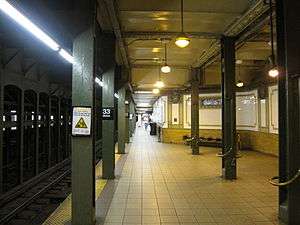
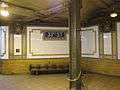
Downtown platform with Arts for Transit artwork on the columns | |||||||||||
| Station statistics | |||||||||||
| Address |
East 33rd Street & Park Avenue New York, NY 10016 | ||||||||||
| Borough | Manhattan | ||||||||||
| Locale | Murray Hill, Kips Bay | ||||||||||
| Coordinates | 40°44′47″N 73°58′55″W / 40.74639°N 73.98194°WCoordinates: 40°44′47″N 73°58′55″W / 40.74639°N 73.98194°W | ||||||||||
| Division | A (IRT) | ||||||||||
| Line | IRT Lexington Avenue Line | ||||||||||
| Services |
4 6 | ||||||||||
| Transit connections |
| ||||||||||
| Structure | Underground | ||||||||||
| Platforms | 2 side platforms | ||||||||||
| Tracks | 4 | ||||||||||
| Other information | |||||||||||
| Opened | October 27, 1904[1] | ||||||||||
| Wireless service |
| ||||||||||
| Traffic | |||||||||||
| Passengers (2015) |
9,701,723[4] | ||||||||||
| Rank | 31 out of 422 | ||||||||||
| Station succession | |||||||||||
| Next north |
Grand Central – 42nd Street: 4 | ||||||||||
| Next south |
28th Street: 4 | ||||||||||
| |||||||||||
| |||||||||||
|
| |||||||||||
|
33rd Street Subway Station (IRT) | |||||||||||
| MPS | New York City Subway System MPS | ||||||||||
| NRHP Reference # | 04001014[5] | ||||||||||
| Added to NRHP | September 17, 2004 | ||||||||||


33rd Street is a local station on the IRT Lexington Avenue Line of the New York City Subway. Located at the intersection of Park Avenue and 33rd Street in the Murray Hill neighborhood of Manhattan, it is served by the 6 train at all times, the <6> during weekdays in peak direction, and the 4 during late night hours.
History
Construction started on the first IRT line in 1900.[6] The part of the line from City Hall to just south of 42nd Street was part of the original IRT line, opened on October 27, 1904 including a local station at 33rd Street.[1]
On April 13, 1948, the platform extensions to accommodate ten-car trains at this station along with those at 23rd Street, and 28th Street were opened for use.[7]
On December 27, 1948, a new entrance at 32nd Street to the 33rd Street station opened for use.[7]
Station layout
| G | Street Level | Exit/Entrance |
| P Platform level |
Side platform, doors will open on the right | |
| Northbound local | ← ← | |
| Northbound express | ← | |
| Southbound express | → | |
| Southbound local | → | |
| Side platform, doors will open on the right | ||
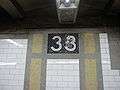
There are four tracks and two side platforms, with the express tracks in the middle, but at a lower level because of the presence of the Murray Hill Tunnel along this section of Park Avenue. The station was recently renovated, and contains eagle plaques similar to those at Brooklyn Bridge – City Hall. The plaques contain the numerals "33". Fare control is at the platform level. The station has been on the National Register of Historic Places since 2004.[5]
Exits
| Exit location | Number of exits | Platform served |
|---|---|---|
| NW corner of Park Avenue and 33rd Street | 1 | Southbound |
| SW corner of Park Avenue and 33rd Street | 1 | Southbound |
| SE corner of Park Avenue and 33rd Street | 1 | Northbound |
| SE corner of Park Avenue S and 32nd Street | 2 | Northbound |
| SW corner of Park Avenue S and 32nd Street | 2 | Southbound |
Image gallery
-
Faience plaque by Heins & LaFarge / Grueby Faience Company, 1904.
-

Tile name tablet by Heins & LaFarge / John H. Parry Co., 1904.
-
-
-

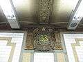
The unique fare control ironwork and Art for Transit installation on the columns
-

Southbound street stairs
-

33rd Street station in 1905
References
- 1 2 New York Times, Our Subway Open: 150,000 Try It, October 28, 1904
- ↑ "NYC Subway Wireless – Active Stations". Transit Wireless Wifi. Retrieved 2016-05-18.
- ↑ Attached PDF to "Governor Cuomo Announces Wireless Service and New "Transit Wireless WiFi" in Queens and Manhattan Subway Stations", governor.ny.gov
- ↑ "Facts and Figures: Annual Subway Ridership". Metropolitan Transportation Authority. Retrieved 2016-04-19.
- 1 2 "NPS Focus". National Register of Historic Places. National Park Service. Retrieved November 6, 2011.
- ↑ "www.nycsubway.org". www.nycsubway.org.
- 1 2 Report for the three and one-half years ending June 30, 1949. New York City Board of Transportation. 1949.
Further reading
- Lee Stokey. Subway Ceramics: A History and Iconography. 1994. ISBN 978-0-9635486-1-0
External links
| Wikimedia Commons has media related to 33rd Street (IRT Lexington Avenue Line). |
- nycsubway.org – IRT East Side Line: 33rd Street
- Station Reporter — 4 Train
- Station Reporter — 6 Train
- Forgotten NY — Original 28 - NYC's First 28 Subway Stations
- MTA's Arts For Transit — 33rd Street (IRT Lexington Avenue Line)
- 32nd Street entrance from Google Maps Street View
- 33rd Street entrance from Google Maps Street View
- downtown platform from Google Maps Street View
| Topics |   | |
|---|---|---|
| Lists by county |
| |
| Lists by city | ||
| Other lists | ||
| ||