Adair County, Missouri
| Adair County, Missouri | |
|---|---|
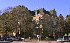 Adair County Courthouse in Kirksville | |
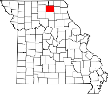 Location in the U.S. state of Missouri | |
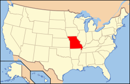 Missouri's location in the U.S. | |
| Founded | January 29, 1841 |
| Named for | John Adair |
| Seat | Kirksville |
| Largest city | Kirksville |
| Area | |
| • Total | 569 sq mi (1,474 km2) |
| • Land | 567 sq mi (1,469 km2) |
| • Water | 2.1 sq mi (5 km2), 0.4% |
| Population (est.) | |
| • (2015) | 25,378 |
| • Density | 45/sq mi (17/km²) |
| Congressional district | 6th |
| Time zone | Central: UTC-6/-5 |
| Website |
adaircountymissouri |
Adair County is a county located in the northeastern part of the U.S. state of Missouri. As of the 2010 Census, the population was 25,607.[1] Its county seat is Kirksville.[2] The county was organized January 29, 1841 and named for Governor John Adair of Kentucky.[3]
Adair County comprises the Kirksville, MO Micropolitan Statistical Area.
History
The first permanent settlement in Adair County began in 1828. Many of the first settlers were from Kentucky, and Adair County was named for John Adair, a respected Governor of Kentucky.[4] This was 25 years after the Louisiana Purchase, seven years after Missouri was granted statehood, and four years after the Sac and Fox Native American tribes surrendered their claims to the land. The original settlement was called "Cabins of White Folks," or simply, "The Cabins," and was located six miles (10 km) west of present-day Kirksville along the Chariton River.
The Big Neck War: In July 1829, a large party of Iowa (or Ioway) Native Americans, led by Chief Big Neck, returned to their former hunting grounds in violation of treaty. One of the Ioway's dogs killed a pig and they threatened (or insulted, according to some sources) the white women. The settlers sent messengers south to Randolph and Macon counties asking for help. Captain William Trammell responded with a party of some two dozen men to help. By the time of their arrival, the Ioways had left the area and moved upriver into what is now Schuyler County. Trammell's force, augmented by several of the men from The Cabins, pursed and engaged the Ioway at a place called Battle Creek, killing several Native Americans including Big Neck's brother, sister-in-law, and their child.[5] The Trammell party lost three men in the skirmish, including Captain Trammell himself, and one additional casualty died of his wounds shortly afterward. The surviving whites returned to the cabins, collected the women and children, and headed south for the Randolph County settlement of Huntsville. Later, a group of militia under General John B. Clark pursued and apprehended Big Neck and his braves, capturing them in March 1830. Soon, several escaped from jail and fled to the current state of Iowa; however, Big Neck himself and the remainder were put on trial by a grand jury of Randolph County. The jury found on March 31, 1830, that: "After examining all the witnesses, and maturely considering the charges for which these Iowa Indians are now in confinement, we find them not guilty, and they are at once discharged."[6] The acquittal of Big Neck seemed to have brought the war to a peaceful, if uneasy, conclusion. A few months later, white settlers returned to The Cabins, this time in greater numbers, and this time to stay permanently. The outbreak of the Blackhawk War in 1832 again caused consternation among the early settlers although all fighting was hundreds of miles away in present-day Illinois and Wisconsin. To ease fears in the area, militia units were dispatched and two small forts were constructed. One, Fort Clark, was located on high ground adjacent to The Cabins. Several miles to the northeast, another detachment of troops established Fort Matson. After months of no hostile Native American activity in the Adair County area, both forts were abandoned. The site of Fort Clark is now marked by a large boulder and plaque, while the Fort Matson site was later the location for a church, name corrupted to Fort Madison (not to be confused with the Iowa city). The Fort Matson/Madison Cemetery still remains.[7]
Courthouse
The Adair County courthouse is a three story Romanesque structure in the center of the Kirksville city square that was completed in 1899. The architect was Robert G. Kirsch who would later also design the courthouses for Carroll, Polk, Vernon, and Cooper counties. The county had no dedicated courthouse from 1865 until 1899, operating out of temporary rented quarters on or near the square. The county voters finally approved a $50,000 bond issue in 1897 to build the current courthouse after four failed attempts between 1872 and 1896. The courthouse was placed on the National Register of Historic Places in 1978.[8][9]
Geography
According to the U.S. Census Bureau, the county has a total area of 569 square miles (1,470 km2), of which 567 square miles (1,470 km2) is land and 2.1 square miles (5.4 km2) (0.4%) is water.[10]
Adjacent counties
- Putnam County (northwest)
- Schuyler County (north)
- Scotland County (northeast)
- Knox County (east)
- Macon County (south)
- Linn County (southwest)
- Sullivan County (west)
Major highways
Demographics
| Historical population | |||
|---|---|---|---|
| Census | Pop. | %± | |
| 1850 | 2,283 | — | |
| 1860 | 8,436 | 269.5% | |
| 1870 | 11,448 | 35.7% | |
| 1880 | 15,190 | 32.7% | |
| 1890 | 17,417 | 14.7% | |
| 1900 | 21,728 | 24.8% | |
| 1910 | 22,700 | 4.5% | |
| 1920 | 21,404 | −5.7% | |
| 1930 | 19,436 | −9.2% | |
| 1940 | 20,246 | 4.2% | |
| 1950 | 19,689 | −2.8% | |
| 1960 | 20,105 | 2.1% | |
| 1970 | 22,472 | 11.8% | |
| 1980 | 24,870 | 10.7% | |
| 1990 | 24,577 | −1.2% | |
| 2000 | 24,977 | 1.6% | |
| 2010 | 25,607 | 2.5% | |
| Est. 2015 | 25,378 | [11] | −0.9% |
| U.S. Decennial Census[12] 1790-1960[13] 1900-1990[14] 1990-2000[15] 2010-2015[1] | |||
As of the census[16] of 2000, there were 24,977 people, 9,669 households, and 5,346 families residing in the county. The population density was 44 people per square mile (17/km²). There were 10,826 housing units at an average density of 19 per square mile (7/km²). The racial makeup of the county was 95.82% White, 1.20% Black or African American, 0.26% Native American, 1.39% Asian, 0.05% Pacific Islander, 0.41% from other races, and 0.88% from two or more races. Approximately 1.26% of the population were Hispanic or Latino of any race.
There were 9,669 households out of which 25.20% had children under the age of 18 living with them, 45.50% were married couples living together, 7.20% had a female householder with no husband present, and 44.70% were non-families. 31.50% of all households were made up of individuals and 10.50% had someone living alone who was 65 years of age or older. The average household size was 2.29 and the average family size was 2.90.
In the county the population was spread out with 19.20% under the age of 18, 27.40% from 18 to 24, 22.80% from 25 to 44, 18.40% from 45 to 64, and 12.30% who were 65 years of age or older. The median age was 28 years. For every 100 females there were 88.20 males. For every 100 females age 18 and over, there were 84.50 males.
The median income for a household in the county was $26,677, and the median income for a family was $38,085. Males had a median income of $26,323 versus $21,837 for females. The per capita income for the county was $15,484. About 11.90% of families and 23.30% of the population were below the poverty line, including 16.80% of those under age 18 and 12.00% of those age 65 or over.
Education
Public schools
- Adair County R-I School District - Novinger
- Adair County R-I Elementary School (K-06)
- Adair County R-I High School (07-12)
- Adair County R-II School District - Brashear
- Adair County R-II Elementary School (K-06)
- Adair County R-II High School (07-12)
- Kirksville R-III School District - Kirksville
- Kirksville Primary School (PK-02)
- Ray Miller Elementary School (03-05)
- Kirksville Middle School (06-08)
- Kirksville High School (09-12)
- La Plata R-2 School District - La Plata
− ** La Plata R-2 Elementary School (K-06) − ** La Plata R-2 High School (07-12) − ** The La Plata R-2 facilities are located in La Plata, Missouri in northern Macon County, Missouri, however the district boundaries encompass part of southern Adair County as well.
Private schools
- Mary Immaculate Catholic School - Kirksville - (K-08) - Roman Catholic
- Life Church School - Kirksville - (K-12) - Nondenominational Christianity
Post-secondary education
- A.T. Still University - Kirksville - (Kirksville College of Osteopathic Medicine) - Satellite Campus
- Truman State University - Kirksville - A public, four-year university.
- Moberly Area Community College - Kirksville - A satellite campus of the main community college campus in Moberly
Politics
Local
Adair County is governed by a three-member commission. The presiding commissioner is elected by the county voters at large. The first district and second district commissioners are voted on by the residents living in the eastern half of the county, and western half of the county respectively. Each commissioner has an equal vote in all county business. Most offices are housed in the Adair County Courthouse, a structure dating from 1896 and listed on the National Register of Historic Places. The Adair County Sheriff's Office is located in the Adair County Detention Center one block north of the courthouse, while the Prosecuting Attorney's office resides in the County Annex building across from the detention center.
| Adair County, Missouri | ||||
|---|---|---|---|---|
| Elected countywide officials | ||||
| Assessor | Donnie Waybill | Republican | ||
| Circuit Clerk | Linda Decker | Democratic | ||
| County Clerk | Sandra Collop | Democratic | ||
| Collector | David O. Erwin | Democratic | ||
| Commissioner (Presiding) |
Stan Pickens | Republican | ||
| Commissioner (District 1) |
Carson Adams | Democratic | ||
| Commissioner (District 2) |
Mark Thompson | Republican | ||
| Coroner | Brian C. Noe | Republican | ||
| Prosecuting Attorney | Matt Wilson | Democratic | ||
| Public Administrator | Rhonda Noe | Republican | ||
| Recorder | Pat Shoush | Republican | ||
| Sheriff | Robert T. Hardwick | Republican | ||
| Surveyor | David W. Borden | Democratic | ||
| Treasurer | Lori J. Smith | Republican | ||
State
| Year | Republican | Democratic | Third Parties |
|---|---|---|---|
| 2012 | 46.55% 4,656 | 50.64% 5,066 | 2.81% 281 |
| 2008 | 48.03% 5,575 | 49.72% 5,771 | 2.25% 262 |
| 2004 | 62.36% 7,019 | 36.37% 4,094 | 1.27% 142 |
| 2000 | 53.93% 5,518 | 43.72% 4,473 | 2.35% 240 |
| 1996 | 34.17% 3,503 | 63.41% 6,501 | 2.42% 248 |
| 1992 | 47.32% 4,931 | 52.68% 5,489 | 0.00% 0 |
Adair County is divided into two legislative districts in the Missouri House of Representatives, both of which are held by Republicans.
- District 3 — Nate Walker (R-Kirksville). Consists of the city of Kirksville and the western half of the rest of the county.
- District 4 — Craig Redmon (R-Canton). Consists of the eastern half of the county.
All of Adair County is a part of Missouri’s 18th District in the Missouri Senate and is currently represented by Brian Munzlinger (R-Williamstown).
Federal
| Party | Candidate | Votes | % | ± | |
|---|---|---|---|---|---|
| Democratic | Claire McCaskill | 5,457 | 54.46 | ||
| Republican | Todd Akin | 4,018 | 40.10 | ||
| Libertarian | Jonathan Dine | 545 | 5.44 | ||
All of Adair County is included in Missouri’s 6th Congressional District and is currently represented by Sam Graves (R-Tarkio) in the U.S. House of Representatives.
| Party | Candidate | Votes | % | ± | |
|---|---|---|---|---|---|
| Republican | Sam B. Graves | 3,899 | 66.98 | +5.43 | |
| Democratic | Bill Hedge | 1,711 | 29.39 | -6.59 | |
| Libertarian | Russ Monchil | 211 | 3.63 | +1.16 | |
| Party | Candidate | Votes | % | ± | |
|---|---|---|---|---|---|
| Republican | Sam Graves | 5,937 | 61.55 | ||
| Democratic | Kyle Yarber | 3,470 | 35.98 | ||
| Libertarian | Russ Monchil | 238 | 2.47 | ||
Federal - Presidential
| Year | Republican | Democratic | Third Parties |
|---|---|---|---|
| 2012 | 55.81% 5,651 | 41.67% 4,219 | 2.32% 256 |
| 2008 | 49.63% 5,891 | 48.31% 5,735 | 2.06% 245 |
| 2004 | 55.83% 6,367 | 43.30% 4,938 | 0.87% 99 |
| 2000 | 57.34% 6,050 | 38.86% 4,101 | 3.80% 401 |
| 1996 | 44.78% 4,656 | 42.71% 4,441 | 12.50% 1,300 |
| 1992 | 38.92% 4,141 | 39.77% 4,232 | 21.31% 2,267 |
2016 Missouri Presidential primary
- Republican
Donald Trump won Adair County with 1,404 votes (40.39%), followed by U.S. Senator Ted Cruz (R-Texas) with 1,164 votes (33.49%), then Governor John Kasich (R-Ohio) with 513 votes (14.76%), and U.S. Senator Marco Rubio (R-Florida) with 299 votes (8.60%).
- Democratic
U.S. Senator Bernie Sanders (I-Vermont) won the Democratic primary with 1,153 votes (58.8%) to Hillary Clinton's 799 votes (40.75%).
2012 Missouri Presidential primary
- Republican
Former U.S. Senator Rick Santorum (R-Pennsylvania) came in first with 397 votes, followed by former Governor Mitt Romney (R-Massachusetts) with 226 votes, and U.S. Representative Ron Paul (R-Texas) with 119 votes.
- Democratic
With there being no serious challenge to incumbent President Barack Obama, few votes were cast in the Democratic primary; Obama won 87% of those votes that were cast.
2008 Missouri Presidential primary
- Republican
Former Governor Mike Huckabee (R-Arkansas) came in first with 735 votes, followed by U.S. Senator John McCain (R-Arizona) with 558 votes, former Governor Mitt Romney (R-Massachusetts) with 451 votes, and U.S. Representative Ron Paul (R-Texas) with 158 votes.
- Democratic
Former U.S. Senator Hillary Clinton (D-New York) received more votes, a total of 1,284, than any candidate from either party in Adair County during the 2008 presidential primary. U.S. Senator Barack Obama (D-Illinois) came in second with 1,216.
Communities
Cities
- Brashear
- Greentop
- Kirksville (county seat)
- Novinger
Villages
Unincorporated communities
Townships
Adair County is divided into ten townships:
See also
References
- 1 2 "State & County QuickFacts". United States Census Bureau. Retrieved September 7, 2013.
- ↑ "Find a County". National Association of Counties. Archived from the original on 2011-05-31. Retrieved 2011-06-07.
- ↑ Eaton, David Wolfe (1916). How Missouri Counties, Towns and Streams Were Named. The State Historical Society of Missouri. p. 200.
- ↑ Violette, E. M. (1911). History of Adair County. The Denslow History Company. p. 34.
- ↑ A Book Of Adair County History, page 34-36. Published 1976 by The Kirksville-Adair County Bicentennial Committee
- ↑ "Archived copy". Archived from the original on 2008-10-15. Retrieved 2010-05-01. History of Randolph County
- ↑ A Book Of Adair County History, page 37-38. Published 1976 by The Kirksville-Adair County Bicentennial Committee
- ↑ "National Register - Adair County". Missouri Department of Natural Resources State Historic Preservation Office. Retrieved 2015-01-17.
- ↑ March, David D. (1977). "Adair County Courthouse National Register of Historic Places Inventory -- Nomination Form" (PDF). Retrieved 2015-01-17.
- ↑ "2010 Census Gazetteer Files". United States Census Bureau. August 22, 2012. Retrieved November 13, 2014.
- ↑ "County Totals Dataset: Population, Population Change and Estimated Components of Population Change: April 1, 2010 to July 1, 2015". Retrieved July 2, 2016.
- ↑ "U.S. Decennial Census". United States Census Bureau. Archived from the original on May 11, 2015. Retrieved November 13, 2014.
- ↑ "Historical Census Browser". University of Virginia Library. Retrieved November 13, 2014.
- ↑ "Population of Counties by Decennial Census: 1900 to 1990". United States Census Bureau. Retrieved November 13, 2014.
- ↑ "Census 2000 PHC-T-4. Ranking Tables for Counties: 1990 and 2000" (PDF). United States Census Bureau. Retrieved November 13, 2014.
- ↑ "American FactFinder". United States Census Bureau. Archived from the original on 2013-09-11. Retrieved 2008-01-31.
External links
- Adair County Government
- Adair County Historical Society
- Digitized 1930 Plat Book of Adair County from University of Missouri Division of Special Collections, Archives, and Rare Books
- Adair County Sheriff's Office
 |
Putnam County | Schuyler County | Scotland County | |
| Sullivan County | |
Knox County | ||
| ||||
| | ||||
| Linn County | Macon County |
Municipalities and communities of Adair County, Missouri, United States | ||
|---|---|---|
| Cities | | |
| Villages | ||
| Townships | ||
| Unincorporated communities | ||
| Ghost towns | ||
| Footnotes | ‡This populated place also has portions in an adjacent county or counties | |
Coordinates: 40°11′N 92°36′W / 40.19°N 92.60°W