Sullivan County, Missouri
| Sullivan County, Missouri | |
|---|---|
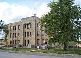 Sullivan County Courthouse in Milan | |
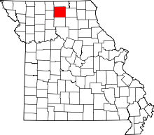 Location in the U.S. state of Missouri | |
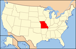 Missouri's location in the U.S. | |
| Founded |
1843 (created) 1845 (organized) |
| Named for | John Sullivan |
| Seat | Milan |
| Largest city | Milan |
| Area | |
| • Total | 652 sq mi (1,689 km2) |
| • Land | 648 sq mi (1,678 km2) |
| • Water | 3.5 sq mi (9 km2), 0.5% |
| Population (est.) | |
| • (2015) | 6,353 |
| • Density | 10/sq mi (4/km²) |
| Congressional district | 6th |
| Time zone | Central: UTC-6/-5 |
Sullivan County is a county located in the northern portion of the U.S. state of Missouri. As of the 2010 census, the population was 6,714.[1] Its county seat is Milan.[2] The county was organized February 14, 1845 and named for Major General John Sullivan of the American Revolutionary War.[3]
History
In 1682, René-Robert Cavelier, Sieur de la Salle claimed the territory west of the Mississippi River for France, which included present-day Sullivan County. The United States acquired this region under terms of the Louisiana Purchase on July 4, 1803. Twenty-one years later, the Sac (Sauk), Meskwaki (Fox), and Iowa Native American nations ceded their tribal land to the U.S. government under two treaties in August 1824.
Dr. Jacob Holland and his son, Robert W. Holland, arrived in 1836, becoming the county's first permanent White settlers. Dr. Holland, a veteran of the Black Hawk War and practitioner of herbal medicine, and son staked their home sites at the Main Locust Creek Settlement near a place called Scottsville.[4] American pioneers from Ohio, Illinois, Kentucky, Tennessee, and Virginia quickly followed them and established farms and small businesses at Pharsalia (Milan) Settlement, Yellow Creek Settlement, and Jackson's Corners (Jacksonville) by 1840.
The Missouri state legislature defined the boundaries of the county from Chariton County during the 1842–1843 legislative session, and first named it Highland County. However, the number of permanent settlers did not meet requirements for civil governance and military purposes, so legislators attached administration of Highland County to Linn County. A new survey of the county in 1844 determined that the population was sufficient to permit full organization. E.M.C. Morelock, a representative from Highland County, presented an act to the state legislature, which they approved on February 14, 1845, and the county became formally organized. By the same act, it was renamed Sullivan County in honor of John Sullivan, a major general in the Continental Army during the American Revolutionary War.[5][6]
Settlers established the town of Milan (pronounced MY-lun) in 1845, located at the center of the county, where the first courts met. William Putnam built the first courthouse, which was occupied in October 1847. Ten years later, residents leveled an Indian mound in the middle of town to make the public square and Major John McCollough built the second courthouse, the first brick structure in Milan, on this site during 1857–1858.[7] (This courthouse was destroyed by fire in 1908 and it was not until 1938 that it was replaced by the three-story limestone building that stands today.[8]) The last federal land office established in Missouri also operated from the square from 1849 to 1859. The state legislature officially incorporated the city of Milan on February 8, 1859. Other towns platted in the county's early years included Greencastle (1857), Newtown (1858), Pollock (1873), Boynton and Cora (1877), Green City and Winigan (1880), Humphreys and Reger (1881), Osgood (1886), and Harris (1887). Green City College opened in 1885, and a business institute opened in Humphreys in 1884.
During the U.S. Civil War (1861–1865), a Union Army post stood in Milan. The Union cause was supported by four Union volunteer infantry regiments, two Union cavalry volunteer regiments, two Missouri Militia units, one provisional militia unit, and a large unit of Sullivan County Home Guards. The Confederate side was supported by four units of Missouri State Guard infantrymen.[9] Soldiers from Sullivan County fought at the Battle of Shiloh, Battle of Atlanta, Battle of Jonesborough, and other major engagements throughout the war. Military skirmishes within the county were mostly confined to bushwhackers.
Expansion of the railroads brought growth to Sullivan County beginning in the 1870s. The C., B. & K.C. (Chicago, Burlington and Kansas City Railway) built a line running north to south through the county in 1876, which was followed by construction of the Quincy, Missouri & Pacific Railway line east to west though the county from 1878 to 1881. The two lines crossed in Milan, which became a major shipping point. The Chicago, Milwaukee & St. Paul Railway soon built a north–south line along Medicine Creek the length of the western edge of the county that served the towns of Newtown and Harris, which continues to be active today. (All three railroads eventually merged into the Chicago, Burlington and Quincy Railroad.)
By 1900, following the railroad construction boom, the county's population exceeded 20,000. However, business activity and the number of residents declined steadily during the subsequent decades. The number of farms decreased from about 3,100 in 1900 to under 900 by 1982, but over the same time period, the size of farms increased from about 130 acres to 385 acres. The county primarily remains rural agricultural land today, planted in corn and grains with family operated poultry, livestock, and dairy farms.[10] One medium size manufacturer in Milan employs about 750 people.
Geography
According to the U.S. Census Bureau, the county has a total area of 652 square miles (1,690 km2), of which 648 square miles (1,680 km2) is land and 3.5 square miles (9.1 km2) (0.5%) is water.[11]
The main water courses in Sullivan County are Medicine, Locust, East Locust, Yellow, and Spring Creeks. The highest point in the county, about 1,060 feet (320 m) above sea level, is on the primary divide between the Chariton River and Grand River drainage basins along its northern border shared with Putnam County northwest of Green City. The lowest point, about 740 feet (230 m) above sea level, is where Locust Creek flows out of the county on its southern border with Linn County, near the town of Browning.[12]
Adjacent counties
- Putnam County (north)
- Adair County (east)
- Linn County (south)
- Grundy County (southwest)
- Mercer County (northwest)
Major highways
Demographics
| Historical population | |||
|---|---|---|---|
| Census | Pop. | %± | |
| 1850 | 2,983 | — | |
| 1860 | 9,108 | 205.3% | |
| 1870 | 11,907 | 30.7% | |
| 1880 | 16,569 | 39.2% | |
| 1890 | 19,000 | 14.7% | |
| 1900 | 20,282 | 6.7% | |
| 1910 | 18,598 | −8.3% | |
| 1920 | 17,781 | −4.4% | |
| 1930 | 15,212 | −14.4% | |
| 1940 | 13,701 | −9.9% | |
| 1950 | 11,299 | −17.5% | |
| 1960 | 8,783 | −22.3% | |
| 1970 | 7,572 | −13.8% | |
| 1980 | 7,434 | −1.8% | |
| 1990 | 6,326 | −14.9% | |
| 2000 | 7,219 | 14.1% | |
| 2010 | 6,714 | −7.0% | |
| Est. 2015 | 6,353 | [13] | −5.4% |
| U.S. Decennial Census[14] 1790-1960[15] 1900-1990[16] 1990-2000[17] 2010-2015[1] | |||
As of the census[18] of 2010, there were 6,714 people, 2,925 households, and 1,959 families residing in the county. The population density was 11 people per square mile (4/km²). There were 3,364 housing units at an average density of 5 per square mile (2/km²). The racial makeup of the county was 88.73% White, 0.51% Black or African American, 0.66% Native American, 0.12% Asian, 0.13% Pacific Islander, 8.67% from other races, and 1.19% from two or more races. Approximately 18.59% of the population were Hispanic or Latino of any race, making Sullivan County the most heavily Hispanic/Latino county in Missouri.
There were 2,925 households out of which 29.60% had children under the age of 18 living with them, 53.30% were married couples living together, 9.10% had a female householder with no husband present, and 33.00% were non-families. 29.10% of all households were made up of individuals and 15.00% had someone living alone who was 65 years of age or older. The average household size was 2.42 and the average family size was 2.95.
In the county the population was spread out with 25.00% under the age of 18, 7.50% from 18 to 24, 26.30% from 25 to 44, 22.70% from 45 to 64, and 18.50% who were 65 years of age or older. The median age was 39 years. For every 100 females there were 100.10 males. For every 100 females age 18 and over, there were 97.70 males.
The median income for a household in the county was $26,107, and the median income for a family was $33,590. Males had a median income of $23,245 versus $19,167 for females. The per capita income for the county was $13,392. About 11.00% of families and 16.50% of the population were below the poverty line, including 19.60% of those under age 18 and 20.90% of those age 65 or over.
Education
Public schools
- Green City R-I School District – Green City
- Green City Elementary School (PK-06)
- Green City High School (07-12)
- Milan C-2 School District – Milan
- Milan Elementary School (PK-04)
- Milan Middle School (05-08)
- Milan High School (09-12)
- Newtown-Harris R-III School District – Newtown
- Newtown-Harris Elementary School (PK-06)
- Newtown-Harris High School (07-12)
Politics
Local
The Republican and Democratic parties equally control politics at the local level in Sullivan County. Both parties hold about half of the elected positions in the county.
| Sullivan County, Missouri | ||||
|---|---|---|---|---|
| Elected countywide officials | ||||
| Assessor | Karen LaFaver | Democratic | ||
| Circuit Clerk | Sherry Brinkley | Democratic | ||
| County Clerk | Jackie Morris | Democratic | ||
| Collector | Jennifer Hollon-Russell | Republican | ||
| Commissioner (Presiding) |
Chris May | Republican | ||
| Commissioner (District 1) |
John Watt | Republican | ||
| Commissioner (District 2) |
Danny Busick | Republican | ||
| Coroner | Paul Ruschmeier | Democratic | ||
| Prosecuting Attorney | Jerry A. Hollon | Democratic | ||
| Public Administrator | Joan Brummitt | Democratic | ||
| Recorder | Peggy Sloan | Republican | ||
| Sheriff | Roger Smiley | Republican | ||
| Surveyor | Brandon Piper | Republican | ||
| Treasurer | Jennifer Hollon-Russell | Republican | ||
State
| Year | Republican | Democratic | Third Parties |
|---|---|---|---|
| 2012 | 54.90% 1,429 | 42.41% 1,104 | 2.69% 70 |
| 2008 | 51.43% 1,476 | 46.03% 1,321 | 2.54% 73 |
| 2004 | 62.45% 1,929 | 35.77% 1,105 | 1.78% 55 |
| 2000 | 58.11% 1,755 | 40.33% 1,218 | 1.56% 47 |
| 1996 | 35.59% 1,084 | 62.57% 1,906 | 1.84% 56 |
Sullivan County is part of Missouri's 3rd district in the Missouri House of Representatives, currently represented by Nate Walker (R-Kirksville).
| Party | Candidate | Votes | % | ± | |
|---|---|---|---|---|---|
| Republican | Nate Walker | 1,300 | 100.00 | ||
| Party | Candidate | Votes | % | ± | |
|---|---|---|---|---|---|
| Republican | Nate Walker | 1,552 | 59.49 | ||
| Democratic | Rebecca McClanahan | 1,057 | 40.51 | ||
Sullivan County is a part of Missouri’s 12th District in the Missouri Senate and is currently represented by Dan Hegeman (R-Cosby).
| Party | Candidate | Votes | % | ± | |
|---|---|---|---|---|---|
| Republican | Dan Hegeman | 1,227 | 100.00 | ||
Federal
| Party | Candidate | Votes | % | ± | |
|---|---|---|---|---|---|
| Republican | Todd Akin | 1,128 | 43.38 | ||
| Democratic | Claire McCaskill | 1,309 | 50.35 | ||
| Libertarian | Jonathan Dine | 163 | 6.27 | ||
Sullivan County is included in Missouri’s 6th Congressional District and is currently represented by Sam Graves (R-Tarkio) in the U.S. House of Representatives.
| Party | Candidate | Votes | % | ± | |
|---|---|---|---|---|---|
| Republican | Sam Graves | 1,172 | 75.81 | +6.70 | |
| Democratic | Bill Hedge | 336 | 21.73 | -7.34 | |
| Libertarian | Russ Lee Monchil | 38 | 2.46 | +0.64 | |
| Party | Candidate | Votes | % | ± | |
|---|---|---|---|---|---|
| Republican | Sam Graves | 1,785 | 69.11 | ||
| Democratic | Kyle Yarber | 751 | 29.07 | ||
| Libertarian | Russ Lee Monchil | 47 | 1.82 | ||
| Year | Republican | Democratic | Third Parties |
|---|---|---|---|
| 2012 | 62.04% 1,610 | 34.99% 908 | 2.97% 77 |
| 2008 | 56.01% 1,607 | 40.89% 1,173 | 3.10% 89 |
| 2004 | 60.86% 1,880 | 38.14% 1,178 | 1.01% 31 |
| 2000 | 61.26% 1,877 | 36.78% 1,127 | 1.96% 60 |
| 1996 | 41.75% 1,275 | 45.91% 1,402 | 12.34% 377 |
Missouri Presidential Preference Primary (2008)
- Former U.S. Senator Hillary Clinton (D-New York) received more votes, a total of 506, than any candidate from either party in Sullivan County during the 2008 presidential primary.
| Sullivan County, Missouri | ||
|---|---|---|
| 2008 Republican primary in Missouri | ||
| John McCain | 197 (32.45%) | |
| Mike Huckabee | 209 (34.43%) | |
| Mitt Romney | 130 (21.42%) | |
| Ron Paul | 60 (9.88%) | |
| Sullivan County, Missouri | ||
|---|---|---|
| 2008 Democratic primary in Missouri | ||
| Hillary Clinton | 506 (71.37%) | |
| Barack Obama | 172 (24.26%) | |
| John Edwards (withdrawn) | 26 (3.67%) | |
Communities
Cities
- Browning
- Green City
- Greencastle
- Harris
- Milan (county seat)
- Newtown
Villages
Census-designated place
Unincorporated communities
Former communities
Source[19]
- Bairdston
- Boynton
- Brown
- Bute
- Cookman
- Cora
- Jacksonville
- Judson
- Lindley
- Mystic
- Opel
- Owasco
- Parsons
- Pawpaw
- Pennville
- Sorrell
- Sticklerville
- Wintersville
Townships
Source[20]
- Bowman
- Buchanan
- Clay
- Duncan
- Jackson
- Liberty
- Morris
- Penn
- Pleasant Hill
- Polk
- Taylor
- Union
Notable residents
- Gene Bartow - Hall of Fame college basketball coach and NBA executive.
- Fred "Killer" Burke - notorious bank robber and gangster, lived under an alias for several months near Green City before being captured there in March 1931.
- Bud Houser - Winner of multiple Olympic medals in track & field events. Born in Winnigan.
- Dave Samuels - Professional DJ & Environmental Engineer
See also
References
- 1 2 "State & County QuickFacts". United States Census Bureau. Retrieved September 14, 2013.
- ↑ "Find a County". National Association of Counties. Retrieved 2011-06-07.
- ↑ Eaton, David Wolfe (1917). How Missouri Counties, Towns and Streams Were Named. The State Historical Society of Missouri. p. 68.
- ↑ MOGenWeb Project, Sullivan County, Missouri, Early Settlements of Sullivan County
- ↑ Sterling, Bill. "Sullivan County (Communities)". Community Histories. SullivanCountyMissouri.com. Retrieved 14 September 2011.
- ↑ "Sullivan County, Missouri". MOGenWeb. Retrieved November 25, 2014.
- ↑ University of Missouri Extension, Encyclopedia of Missouri Courthouses, Sullivan County Courthouse. Retrieved 14 September 2011.
- ↑ Sterling, Bill. "Courthouse History". County History. SullivanCountyMissouri.com. Retrieved 14 September 2011.
- ↑ Sterling, Bill. "Sullivan County Civil War Regiments". County History. SullivanCountyMissouri.com. Retrieved 14 September 2011.
- ↑ United States Department of Agriculture, Soil Survey of Sullivan County, Missouri, April 1985
- ↑ "2010 Census Gazetteer Files". United States Census Bureau. August 22, 2012. Retrieved November 22, 2014.
- ↑ United States Department of Agriculture, Soil Survey of Sullivan County, Missouri, April 1995.
- ↑ "County Totals Dataset: Population, Population Change and Estimated Components of Population Change: April 1, 2010 to July 1, 2015". Retrieved July 2, 2016.
- ↑ "U.S. Decennial Census". United States Census Bureau. Retrieved November 22, 2014.
- ↑ "Historical Census Browser". University of Virginia Library. Retrieved November 22, 2014.
- ↑ "Population of Counties by Decennial Census: 1900 to 1990". United States Census Bureau. Retrieved November 22, 2014.
- ↑ "Census 2000 PHC-T-4. Ranking Tables for Counties: 1990 and 2000" (PDF). United States Census Bureau. Retrieved November 22, 2014.
- ↑ "American FactFinder". United States Census Bureau. Retrieved 2008-01-31.
- ↑ GNIS, Query Results: Sullivan County, Missouri
- ↑ MOGenWeb Project, Sullivan County Townships
External links
- Digitized 1930 Plat Book of Sullivan County from University of Missouri Division of Special Collections, Archives, and Rare Books
- SullivanCountyMissouri.com, local history and information.
- TheLibrary.org, A Directory of Towns, Villages, and Hamlets Past and Present of Sullivan County, Missouri.
 |
Mercer County | Putnam County | | |
| |
Adair County | |||
| ||||
| | ||||
| Grundy County | Linn County | Macon County |
Municipalities and communities of Sullivan County, Missouri, United States | ||
|---|---|---|
| Cities | | |
| Villages | ||
| CDP | ||
| Unincorporated communities | ||
| Footnotes | ‡This populated place also has portions in an adjacent county or counties | |
Coordinates: 40°13′N 93°07′W / 40.21°N 93.11°W