Ballwin, Missouri
| Ballwin, Missouri | |
|---|---|
| City | |
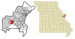 Location of Ballwin in St. Louis County and Missouri | |
| Coordinates: 38°35′41″N 90°32′54″W / 38.59472°N 90.54833°WCoordinates: 38°35′41″N 90°32′54″W / 38.59472°N 90.54833°W | |
| Country |
|
| State |
|
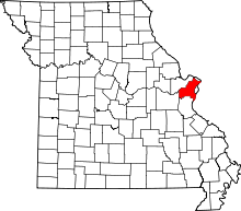
| County | St. Louis |
| Incorporated | December 29, 1950[1] |
| Government | |
| • Mayor | Tim Pogue |
| Area[2] | |
| • Total | 8.99 sq mi (23.28 km2) |
| • Land | 8.99 sq mi (23.28 km2) |
| • Water | 0 sq mi (0 km2) |
| Elevation | 630 ft (192 m) |
| Population (2010)[3] | |
| • Total | 30,404 |
| • Estimate (2015[4]) | 30,577 |
| • Density | 3,382.0/sq mi (1,305.8/km2) |
| Time zone | Central (CST) (UTC-6) |
| • Summer (DST) | CDT (UTC-5) |
| FIPS code | 29-03160[5] |
| GNIS feature ID | 0755721[6] |
| Website | ballwin.mo.us |
Ballwin is a second-ring western suburb of St. Louis, located in St. Louis County, Missouri, United States. The population was 30,404 as of the 2010 census. It was named by Money magazine in 2005, 2011, and 2013 as one of the 100 best places to live in America.[7][8]
History
Ballwin was named for John Ball, who settled at the town site in 1804.[9]
Geography
Ballwin is located at 38°35′41″N 90°32′54″W / 38.59472°N 90.54833°W (38.594820, −90.548420).[10] According to the United States Census Bureau, the city has a total area of 8.99 square miles (23.28 km2), all of it land.[2]
Demographics
| Historical population | |||
|---|---|---|---|
| Census | Pop. | %± | |
| 1850 | 84 | — | |
| 1880 | 159 | — | |
| 1960 | 5,710 | — | |
| 1970 | 10,656 | 86.6% | |
| 1980 | 12,656 | 18.8% | |
| 1990 | 21,816 | 72.4% | |
| 2000 | 31,283 | 43.4% | |
| 2010 | 30,404 | −2.8% | |
| Est. 2015 | 30,577 | [11] | 0.6% |
| U.S. Decennial Census | |||
2010 census
As of the census[3] of 2010, there were 30,404 people, 11,874 households, and 8,631 families residing in the city. The population density was 3,382.0 inhabitants per square mile (1,305.8/km2). There were 12,435 housing units at an average density of 1,383.2 per square mile (534.1/km2). The racial makeup of the city was 89.3% White, 2.5% African American, 0.2% Native American, 5.6% Asian, 0.6% from other races, and 1.7% from two or more races. Hispanic or Latino of any race were 2.4% of the population.
There were 11,874 households of which 34.2% had children under the age of 18 living with them, 60.9% were married couples living together, 8.8% had a female householder with no husband present, 3.0% had a male householder with no wife present, and 27.3% were non-families. 23.1% of all households were made up of individuals and 9.4% had someone living alone who was 65 years of age or older. The average household size was 2.56 and the average family size was 3.04.
The median age in the city was 41.2 years. 24.9% of residents were under the age of 18; 6.8% were between the ages of 18 and 24; 23.7% were from 25 to 44; 29.5% were from 45 to 64; and 15.1% were 65 years of age or older. The gender makeup of the city was 48.2% male and 51.8% female.
2000 census
As of the census[5] of 2000, there were 31,283 people, 11,797 households, and 8,942 families residing in the city. The population density was 3,494.6 people per square mile (1,349.5/km²). There were 12,062 housing units at an average density of 1,347.4 per square mile (520.4/km²). The racial makeup of the city was 93.39% White, 1.50% African American, 0.22% Native American, 3.27% Asian, 0.04% Pacific Islander, 0.51% from other races, and 1.07% from two or more races. Hispanic or Latino of any race were 1.86% of the population.
There were 11,797 households out of which 37.2% had children under the age of 18 living with them, 65.6% were married couples living together, 8.0% had a female householder with no husband present, and 24.2% were non-families. 20.6% of all households were made up of individuals and 7.3% had someone living alone who was 65 years of age or older. The average household size was 2.65 and the average family size was 3.09.
In the city, the population was spread out with 27.0% under the age of 18, 6.4% from 18 to 24, 29.9% from 25 to 44, 24.5% from 45 to 64, and 12.1% who were 65 years of age or older. The median age was 38 years. For every 100 females there were 94.2 males. For every 100 females age 18 and over, there were 91.6 males.
The median income for a household in the city was $66,458 and the median income for a family was $77,021 (these figures had risen to $76,931 and $94,989 respectively as of a 2007 estimate[12]). Males had a median income of $56,056 versus $32,202 for females. The per capita income for the city was $29,520. About 2.0% of families and 3.2% of the population were below the poverty line, including 3.1% of those under age 18 and 3.7% of those age 65 or over.
Education
Ballwin is home to many schools within Parkway School District, including Claymont,[13] Hanna Woods,[14] Henry,[15] Oak Brook,[16] and Sorrento Springs[17] elementary schools, and Parkway West High School.[18]
Ballwin also contains several schools within Rockwood School District, including Ballwin,[19] Westridge,[20] and Woerther[21] elementary schools, as well as Selvidge Middle School.[22]
Business
Lion's Choice, a roast beef fast food chain, was founded in Ballwin.
References
- ↑ "Archived copy". Archived from the original on 2016-06-24. Retrieved 2016-05-27.
- 1 2 "US Gazetteer files 2010". United States Census Bureau. Archived from the original on July 14, 2012. Retrieved 2012-07-08.
- 1 2 "American FactFinder". United States Census Bureau. Retrieved 2012-07-08.
- ↑ "Population Estimates". United States Census Bureau. Retrieved 2016-06-08.
- 1 2 "American FactFinder". United States Census Bureau. Archived from the original on September 11, 2013. Retrieved 2008-01-31.
- ↑ "US Board on Geographic Names". United States Geological Survey. 2007-10-25. Retrieved 2008-01-31.
- ↑ Ballwin in Money Magazine
- ↑
- ↑ Eaton, David Wolfe (1918). How Missouri Counties, Towns and Streams Were Named. The State Historical Society of Missouri. p. 359.
- ↑ "US Gazetteer files: 2010, 2000, and 1990". United States Census Bureau. 2011-02-12. Retrieved 2011-04-23.
- ↑ "Annual Estimates of the Resident Population for Incorporated Places: April 1, 2010 to July 1, 2015". Retrieved July 2, 2016.
- ↑ http://factfinder.census.gov/servlet/ACSSAFFFacts?_event=Search&geo_id=16000US2758738&_geoContext=01000US%7C04000US27%7C16000US2758738&_street=&_county=ballwin&_cityTown=ballwin&_state=04000US29&_zip=&_lang=en&_sse=on&ActiveGeoDiv=geoSelect&_useEV=&pctxt=fph&pgsl=160&_submenuId=factsheet_1&ds_name=ACS_2007_3YR_SAFF&_ci_nbr=null&qr_name=null®=null%3Anull&_keyword=&_industry=
- ↑ http://www.pkwy.k12.mo.us/claymont/index.cfm
- ↑ http://www.pkwy.k12.mo.us/hanna/ Retrieved 2011-01-08
- ↑ http://www.pkwy.k12.mo.us/henry/ Retrieved 2011-01-08
- ↑ http://www.pkwy.k12.mo.us/oakbrook/index.cfm Retrieved 2011-01-08
- ↑ http://www.pkwy.k12.mo.us/sorrento/aboutSorrento.cfm Retrieved 2012-07-15
- ↑ http://www.pkwy.k12.mo.us/west/about/contact.cfm Retrieved 2011-01-08
- ↑ http://www.rockwood.k12.mo.us/ballwin/Pages/default.aspx Retrieved 2011-01-08
- ↑ http://www.rockwood.k12.mo.us/westridge/Pages/default.aspx Retrieved 2011-01-08
- ↑ http://www.rockwood.k12.mo.us/woerther/Pages/default.aspx Retrieved 2011-01-08
- ↑ http://www.rockwood.k12.mo.us/selvidge/Pages/default.aspx Retrieved 2011-01-08
External links
| Topics |  | |
|---|---|---|
| Central city | ||
| Largest cities (over 50,000 in 2010) | ||
| Medium-sized cities (over 20,000 in 2010) | ||
| Largest towns and villages (over 10,000 in 2010) |
| |
| Missouri Counties | ||
| Illinois Counties | ||
| Subregions | ||