Constableville Village Historic District
|
Constableville Village Historic District | |
|
Constableville Village Historic District, June 2011 | |
 | |
| Location | Roughly bounded by Sugar River, Main, N. Main, W. Main, Church, High, West and James Sts., Constableville, New York |
|---|---|
| Coordinates | 43°33′51″N 75°25′50″W / 43.56417°N 75.43056°WCoordinates: 43°33′51″N 75°25′50″W / 43.56417°N 75.43056°W |
| Area | 59.4 acres (24.0 ha) |
| Built | 1828 |
| Architect | Multiple |
| Architectural style | Late Victorian |
| NRHP Reference # | 83001703[1] |
| Added to NRHP | September 15, 1983 |
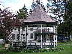
Constableville Village Historic District is a national historic district located at Constableville in Lewis County, New York. The district includes 105 contributing buildings, one contributing structure, and one contributing site. The buildings are commercial, residential, civic, and church structures built primarily between about 1828 and 1900. Also included are a rural cemetery dating from the late 19th century, one historic bridge, and an early 20th-century school.[2]
It was listed on the National Register of Historic Places in 1983.[1]
References
- 1 2 National Park Service (2009-03-13). "National Register Information System". National Register of Historic Places. National Park Service.
- ↑ John F. Harwood (August 1983). "National Register of Historic Places Registration: Constableville Village Historic District". New York State Office of Parks, Recreation and Historic Preservation. Retrieved 2009-12-10. See also: "Accompanying 19 photos".
| Topics |   | |
|---|---|---|
| Lists by county |
| |
| Lists by city | ||
| Other lists | ||
| ||
This article is issued from Wikipedia - version of the 11/27/2016. The text is available under the Creative Commons Attribution/Share Alike but additional terms may apply for the media files.