Gasny
| Gasny | ||
|---|---|---|
 | ||
| ||
 Gasny | ||
|
Location within Normandy region  Gasny | ||
| Coordinates: 49°05′34″N 1°36′18″E / 49.0928°N 1.605°ECoordinates: 49°05′34″N 1°36′18″E / 49.0928°N 1.605°E | ||
| Country | France | |
| Region | Normandy | |
| Department | Eure | |
| Arrondissement | Les Andelys | |
| Canton | Écos | |
| Intercommunality | Portes de l'Eure | |
| Government | ||
| • Mayor (2008–2014) | Pascal Jolly | |
| Area1 | 12.89 km2 (4.98 sq mi) | |
| Population (2008)2 | 2,876 | |
| • Density | 220/km2 (580/sq mi) | |
| Time zone | CET (UTC+1) | |
| • Summer (DST) | CEST (UTC+2) | |
| INSEE/Postal code | 27279 / 27620 | |
| Elevation |
19–136 m (62–446 ft) (avg. 36 m or 118 ft) | |
|
1 French Land Register data, which excludes lakes, ponds, glaciers > 1 km² (0.386 sq mi or 247 acres) and river estuaries. 2 Population without double counting: residents of multiple communes (e.g., students and military personnel) only counted once. | ||
.svg.png)
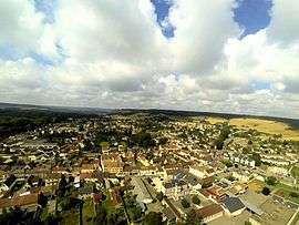
Gasny is a commune in the Eure department in northern France.
Population
| Historical population | ||
|---|---|---|
| Year | Pop. | ±% |
| 1793 | 990 | — |
| 1800 | 1,105 | +11.6% |
| 1806 | 1,052 | −4.8% |
| 1821 | 1,091 | +3.7% |
| 1831 | 1,124 | +3.0% |
| 1836 | 1,182 | +5.2% |
| 1841 | 1,186 | +0.3% |
| 1846 | 1,170 | −1.3% |
| 1851 | 1,136 | −2.9% |
| 1856 | 1,040 | −8.5% |
| 1861 | 974 | −6.3% |
| 1866 | 897 | −7.9% |
| 1872 | 836 | −6.8% |
| 1876 | 830 | −0.7% |
| 1881 | 801 | −3.5% |
| 1886 | 822 | +2.6% |
| 1891 | 863 | +5.0% |
| 1896 | 823 | −4.6% |
| 1901 | 904 | +9.8% |
| 1906 | 848 | −6.2% |
| 1911 | 907 | +7.0% |
| 1921 | 877 | −3.3% |
| 1926 | 914 | +4.2% |
| 1931 | 935 | +2.3% |
| 1936 | 930 | −0.5% |
| 1946 | 949 | +2.0% |
| 1954 | 1,066 | +12.3% |
| 1962 | 1,327 | +24.5% |
| 1968 | 1,645 | +24.0% |
| 1975 | 2,040 | +24.0% |
| 1982 | 2,638 | +29.3% |
| 1990 | 2,957 | +12.1% |
| 1999 | 2,943 | −0.5% |
| 2008 | 2,876 | −2.3% |
See also
References
| Wikimedia Commons has media related to Gasny. |
This article is issued from Wikipedia - version of the 2/12/2016. The text is available under the Creative Commons Attribution/Share Alike but additional terms may apply for the media files.