Villiers-en-Désœuvre
| Villiers-en-Désœuvre | |
|---|---|
|
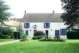
Town hall | |
 Villiers-en-Désœuvre | |
|
Location within Normandy region  Villiers-en-Désœuvre | |
| Coordinates: 48°56′54″N 1°29′19″E / 48.9483°N 1.4886°ECoordinates: 48°56′54″N 1°29′19″E / 48.9483°N 1.4886°E | |
| Country | France |
| Region | Normandy |
| Department | Eure |
| Arrondissement | Évreux |
| Canton | Villiers-en-Désœuvre |
| Intercommunality | Portes de l'Eure |
| Government | |
| • Mayor (2008–2014) | Christian Bidot |
| Area1 | 14.65 km2 (5.66 sq mi) |
| Population (2008)2 | 918 |
| • Density | 63/km2 (160/sq mi) |
| Time zone | CET (UTC+1) |
| • Summer (DST) | CEST (UTC+2) |
| INSEE/Postal code | 27696 / 27640 |
| Elevation |
82–167 m (269–548 ft) (avg. 139 m or 456 ft) |
|
1 French Land Register data, which excludes lakes, ponds, glaciers > 1 km² (0.386 sq mi or 247 acres) and river estuaries. 2 Population without double counting: residents of multiple communes (e.g., students and military personnel) only counted once. | |
Villiers-en-Désœuvre is a commune in the Eure department in Haute-Normandie in northern France.
Population
| Historical population | ||
|---|---|---|
| Year | Pop. | ±% |
| 1962 | 437 | — |
| 1968 | 461 | +5.5% |
| 1975 | 439 | −4.8% |
| 1982 | 552 | +25.7% |
| 1990 | 687 | +24.5% |
| 1999 | 802 | +16.7% |
| 2008 | 918 | +14.5% |
See also
References
| Wikimedia Commons has media related to Villiers-en-Désœuvre. |
This article is issued from Wikipedia - version of the 2/12/2016. The text is available under the Creative Commons Attribution/Share Alike but additional terms may apply for the media files.