Saint-Pierre-de-Salerne
| Saint-Pierre-de-Salerne | |
|---|---|
|
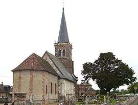
Church | |
 Saint-Pierre-de-Salerne | |
|
Location within Normandy region  Saint-Pierre-de-Salerne | |
| Coordinates: 49°12′09″N 0°39′53″E / 49.2025°N 0.6647°ECoordinates: 49°12′09″N 0°39′53″E / 49.2025°N 0.6647°E | |
| Country | France |
| Region | Normandy |
| Department | Eure |
| Arrondissement | Bernay |
| Canton | Brionne |
| Government | |
| • Mayor (2008–2014) | Josiane Marescal |
| Area1 | 6.92 km2 (2.67 sq mi) |
| Population (2008)2 | 249 |
| • Density | 36/km2 (93/sq mi) |
| Time zone | CET (UTC+1) |
| • Summer (DST) | CEST (UTC+2) |
| INSEE/Postal code | 27592 / 27800 |
| Elevation |
50–162 m (164–531 ft) (avg. 149 m or 489 ft) |
|
1 French Land Register data, which excludes lakes, ponds, glaciers > 1 km² (0.386 sq mi or 247 acres) and river estuaries. 2 Population without double counting: residents of multiple communes (e.g., students and military personnel) only counted once. | |
Saint-Pierre-de-Salerne is a commune in the Eure department in Haute-Normandie in northern France.
Population
| Historical population | ||
|---|---|---|
| Year | Pop. | ±% |
| 1962 | 155 | — |
| 1968 | 170 | +9.7% |
| 1975 | 162 | −4.7% |
| 1982 | 193 | +19.1% |
| 1990 | 210 | +8.8% |
| 1999 | 204 | −2.9% |
| 2008 | 249 | +22.1% |
See also
References
| Wikimedia Commons has media related to Saint-Pierre-de-Salerne. |
This article is issued from Wikipedia - version of the 2/11/2016. The text is available under the Creative Commons Attribution/Share Alike but additional terms may apply for the media files.